Parts of Europe have seen unprecedented heat since the beginning of the month. Temperatures across Spain have hit record highs for October, with the unseasonable heat likely to last into the weekend. The latest heatwave began last Friday, with temperatures peaking on Sunday at 38.2°C in the southern town of Montoro near Cordoba, this set a new October maximum temperature record for mainland Spain. The previous October record of 37.5°C was set in 2014, in the southern town of Marbella. A new provisional October maximum temperature record for mainland France of 35.8C was also reached at Navarrenx in the southwest of the country. Austria and Poland also set new October maximum temperature records.
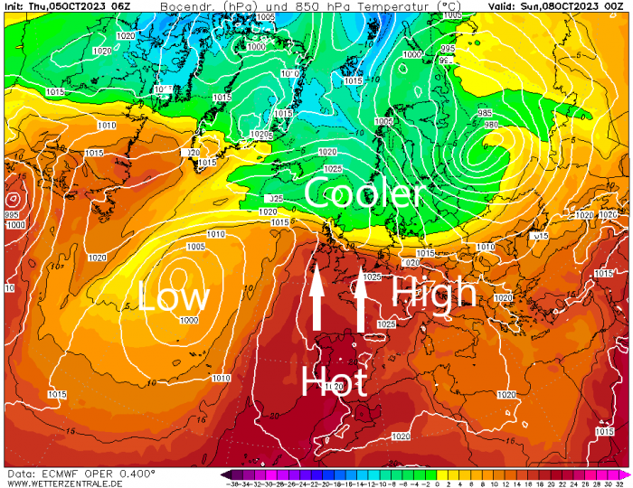
Temperatures look set to reach the mid-30s degrees Celsius across southern Portugal and southwest Spain today, tomorrow and Saturday, low 30s over SW France. Some of this heat will be drawn north into southern Britain over the weekend too, as a high pressure heat dome expands north across NW Europe, bringing a fine weekend for much of England and Wales. Temperatures, with sunshine, could reach 25C across SE England on Sunday. However, it will be a rather different story for Scotland, after more rain on Friday for southern and western areas, rain will become extensive and persistent on Saturday, heavy in places, particularly across higher ground in the west. Some large rainfall totals are possible before the rain finally clears Sunday morning, with over 100mm falling over higher ground, Met Office warnings are in force for the risk of flooding from this potential for large amounts of rain.
Back to the rest of today, an area of low pressure moving northeast to the northwest of the British Isles is pulling a set of fronts across northern Britain, bringing a cloudy and wet picture to Scotland, northern England, N. Ireland and north Wales this afternoon. The heavier and more persistent rain across northern areas will gradually clear eastwards this evening, with drier and perhaps brighter conditions following from the west, but perhaps remaining cloudy with drizzle in the northwest. Southern areas of Wales and England have been mostly dry and bright today and will stay dry into if increasingly cloudy into the evening.
Cloudy, breezy and very mild for most overnight with further spells of rain moving in from the west across western and some northern areas from north Wales northwards. South Wales, central, southern and eastern England along with eastern Scotland staying mostly dry. Temperatures falling no lower than the mid-teens in places.
Further rain for northern areas on Friday, particularly N. Ireland, NW England, southern and western Scotland during the day, then rain becoming more persistent and extensive across Scotland during the evening, heavy across higher ground in the west. The rest of England and Wales generally drier and brighter, with some warm spells of sunshine developing – as high pressure continues to build north here.
Plenty of rain to come for Scotland between Friday and early Sunday, over 100mm over central and western high ground.
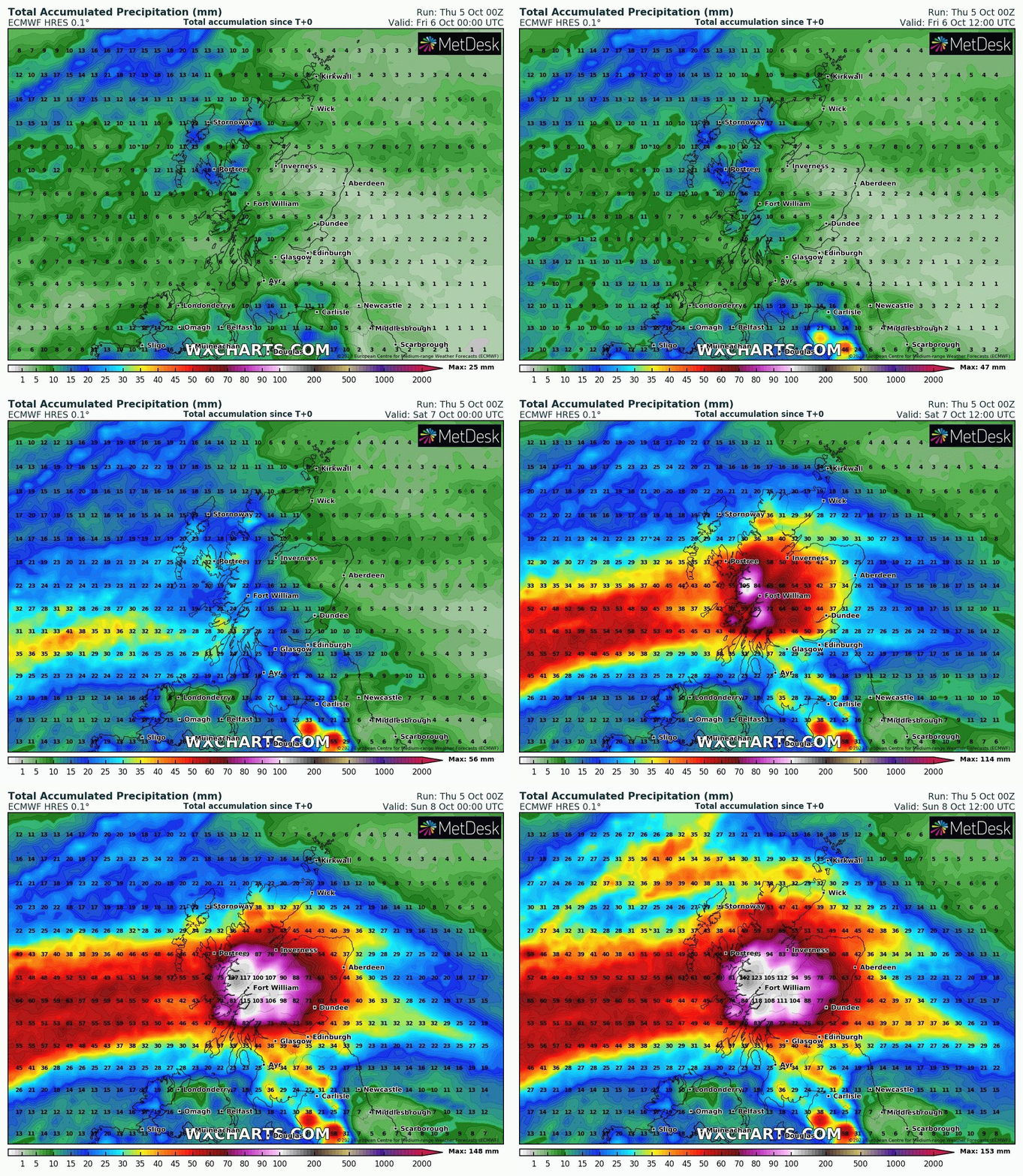
And the rain just keeps on coming across Scotland as we head into the weekend, after a wet night, much of Scotland will see further spells of rain spreading east along a slow-moving frontal boundary on Saturday, with the rain only clearing Sunday morning. So, rainfall totals will pile up across Scotland, particularly across the west. Parts of the central and western Highlands could see well in excess of 100mm (4 inches) of rain fall before the rain eases northeast Sunday morning, elsewhere across Scotland could see in excess of 50mm (2 inches), though lesser amounts towards the northeast and east of Scotland sheltered by high ground to the west. The Met Office have yellow rain warnings in force covering all over Saturday and Sunday morning until 6am.
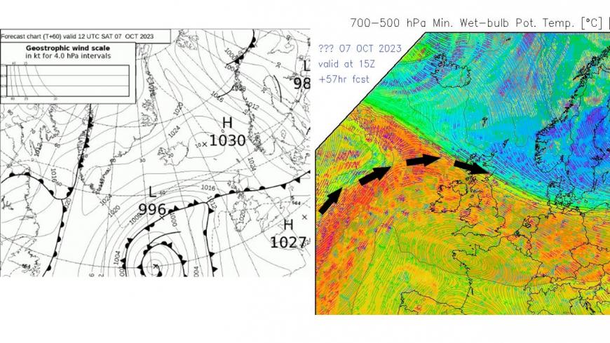
Warm and moist tropical maritime air flowing in from the Atlantic and forced upwards against cooler air to the north of frontal boundary along with orographic lift likely to bring large rainfall totals to Scotland by Sunday
Temperatures will really struggle under the cloud and rain across Scotland on Saturday, but in stark contrast, it will feel more like summer south of the border, with drier and brighter weather with some warm sunny spells, especially across central, southern and eastern England, where temperatures look like reaching the low to mid-20s Celsius. Further west, the high teens to low twenties.
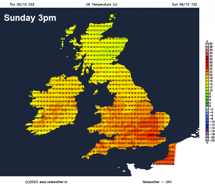
Early rain clearing northeast from northern Scotland on Sunday morning, then some sunny spells before showers or longer spells of rain spread in from the west. Similar day to Saturday for England and Wales on Sunday, high pressure bringing warm sunny spells, best of the sunshine towards SE England and East Anglia – where temperatures could reach the mid-20s Celsius again. High teens to low 20s elsewhere.
High pressure looks to dominate most of England and Wales early next week, bringing fine, dry and unseasonably warm conditions, especially with any sunshine. Scotland, especially the north, still exposed to Atlantic frontal systems, so cloudy at times with further spells of rain.
Loading recent activity...