In the aftermath of Storm Hilary's tropical rain and flooding for western states, Texas and Mexico are watching Tropical Storm Harold as Tropical Storm Franklin heads for the Dominican Republic.
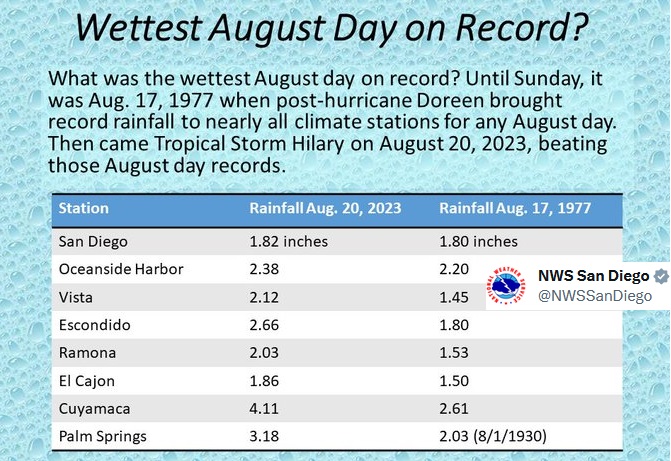
The Atlantic hurricane season has pepped up this week as west coast CONUS saw terrible flooding to start the week. This was in torrential rains from Storm Hilary, which had been a hurricane in the eastern Pacific. Downtown LA saw 2.48” rain (6.3cm) on Sunday 20th which made it the wettest August day on record at that location. The previous record was from August 1977.
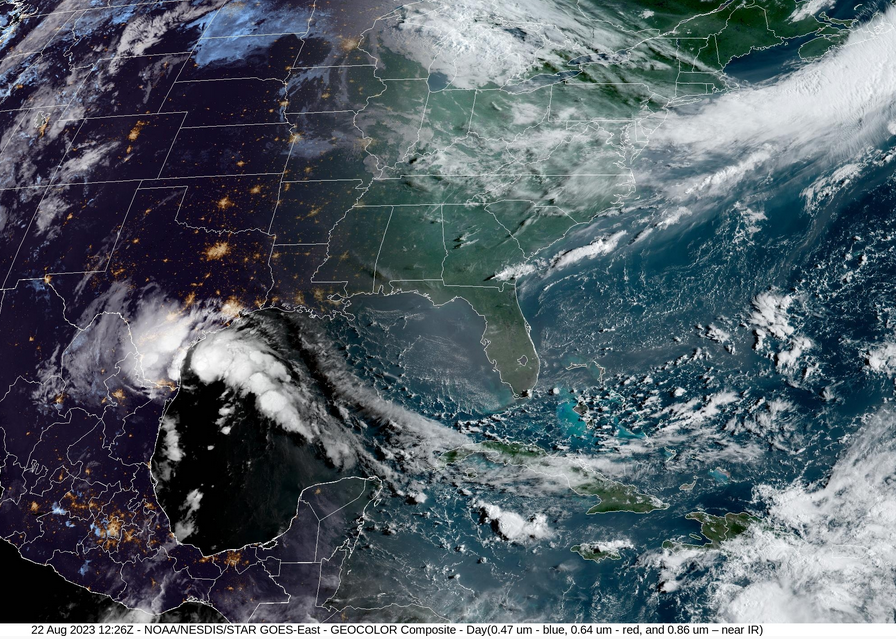
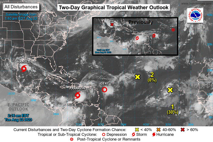
Several Tropical Storms have since formed in the Atlantic with TS Harold forecast to reach southern Texas tonight and TS Franklin heading for the Dominican Republic.
The National Weather Service (NWS) in the US headlines with “Heavy Rain, Oppressive Heat and Monitoring the Gulf”
“Rainfall associated with post-tropical cyclone Hilary may still produce flash and urban flooding across parts of the West today. A heat dome will consume the Plains and Mississippi Valley into the South this week with oppressive and dangerous conditions. Potential Tropical Cyclone Nine (now TS Harold) has formed in the central Gulf of Mexico“
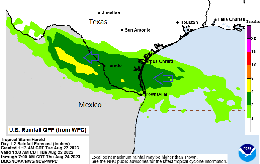
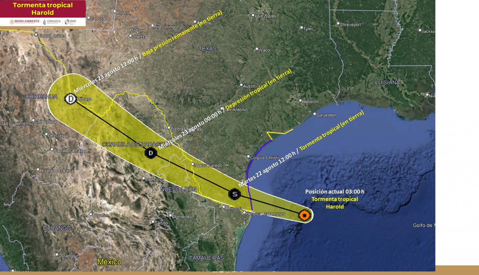
Tropical Storm Harold is forecast to make landfall in the far southeast of Texas late on Tuesday 22nd with coastal flooding and wild conditions. There are concerns about tornadoes forming and a critical Fire Risk as a belt of strong and gusty winds develops over central Texas, ahead of the storm. Here the conditions are dry and very hot. As Harold tracks inland, moving WNW, it will waver into northern Mexico and potentially back into southwest Texas by Wednesday afternoon but as a weakening feature by then.
Heavy rain is forecast to move over the far south of Texas early on Wednesday from Harold and could produce flash flooding here. Also, a risk of flooding or landslides in the more mountainous regions inland, in northern Mexico
Tropical Storm Gert faded east of Antigua and Tropical Storm Emily didn’t last very long at all, out at sea.
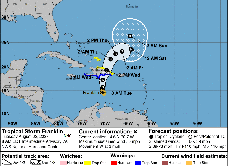
Tropical Storm Franklin is forecast to reach the southern coast of Hispaniola on Wednesday, traverse the island and move off of the northern coast on Thursday. So heavy rain for Dominican Republic, Haiti and also Puerto Rico. This brings the risk of flash flooding and landslides. It is forecast to strength to hurricane strength at the weekend. Tropical Storm Watches are already in place.
Death Valley is the hottest, driest and lowest National Park in the US. It has been closed since Sunday due to the rains from TS Hilary. There was flash flooding and many roads experienced significant debris flows, undercutting and complete shoulder loss. When such rare rainstorms do occur vast fields of wildflowers appear in the aftermath. Interstate 10 was also badly affected by flooding, damage and silt.
“Catastrophic and Life-Threatening Flooding Likely Over Baja California and Portions of the Southwestern U. S. Through Monday (21st August).” NHC
As a Hurricane, Hilary had moved along the west coast of Mexico last week reaching Major hurricane, category 4 status last Friday. The NHC issued its first ever Tropical Storm Watch for parts of southern CA. This became a warning later as it moved towards the coast. Its tropical downpours affected much of California and Nevada with an historic amount of rainfall in the region.
Hilary did not make landfall in southern California; it was over the northern Baja California Peninsula in Mexico as a tropical storm on Sunday 20th. It managed to maintain its Tropical Storm status as it moved into southern CA. This is very rare. Remnants of storms or Tropical Depressions do reach the area but not usually as an active TS.
It is hard for cyclones to keep going in this part of the world due to cool ocean waters and the prevailing trade winds which would usually steer them offshore. These winds also aid upwelling ocean currents along the coast.
“the California Current which brings cold waters from Alaska south along the West Coast and northern Baja California” NOAA
In late summer/September, the waters can warm just enough to support tropical systems but not enough to keep a hurricane going. Hence, Hilary was weakening as it approached Mexico and the United States.
“With Hilary, the normal easterly winds were shifted farther away from the coastline. Instead, there was a strong ridge of high pressure over the south-central United States (the heat dome) and mid- to upper-level low-pressure system off the West Coast, which allowed the storm to be pulled much farther north in the flow between the two systems. “ NOAA
The latest update from NWS - Harold Forecast to Arrive In South Texas; Heat Impacting Millions
“Tropical Storm Harold is forecast to arrive into south Texas by midday today (Tues 22nd) and expected to produce heavy rain, flash and urban flooding, tropical storm conditions, coastal flooding and a couple of tornadoes. Meanwhile, millions are being affected by the sweltering heat and oppressive conditions in the Plains, South and Mississippi, Ohio and Tennessee Valleys.”
The heat continues for central states. New York City is looking fine for midweek before showers appear. It stays warm at around 75F to 80F (27C). For DisneyWorld, Orlando it is hot with temperatures of 93F (34C), the risk of thunderstorms but fine, sunny spells too.