Warm and humid this week, with sunny spells and scattered showers most days, more organised area of rain tomorrow morning moving northeast. Friday driest and warmest day. Hot next weekend in the south.
While the recent heatwave is now over, ending in some spectacular thunderstorms for some, it will remain warm and humid throughout the coming week, with a risk of showers or thunderstorms, but also a lot of dry weather.
Mixed bag of warm sunny spells but also scattered shower or spells of rain next few days, but feeling warm and humid. Drier on Friday:
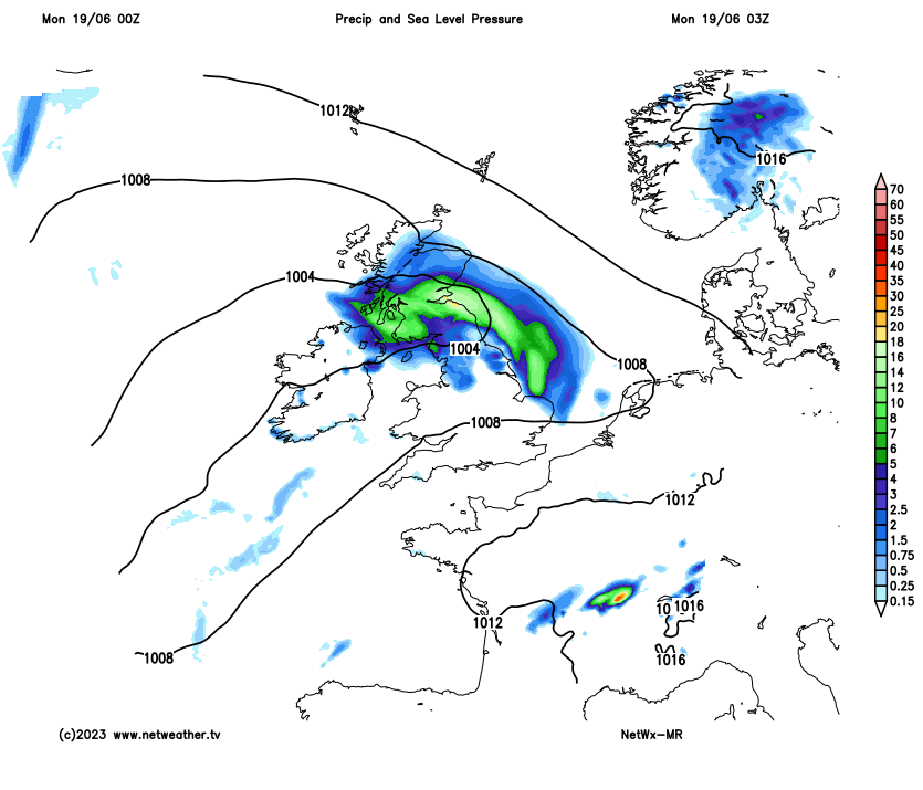
Thunderstorms that developed over England and Wales on Sunday, bringing some welcome rain for some, but also some flooding for others, merged into an area of heavy rain which is now clearing north over northern Scotland. The rain may linger across NW Scotland through today, but for most it will be a breezier and slightly cooler day - but still warm day with sunny spells but also scattered showers developing, most of which will be across the north and west – where they could be heavy and thundery. An area of heavy and thundery rain moving up from the Bay of Biscay tonight clears northeast across England and Wales through Tuesday morning clearing out into the North Sea in the afternoon followed by sunny spells but also scattered showers in the west.
For today, last night's heavy and thundery rain moving north over northern areas is now clearing the far north of Scotland, but will tend to curl back in across the western Highlands through the day. Otherwise the rest of Scotland will see sunny spells but also a scattering of heavy and perhaps thundery showers develop, with thunderstorms perhaps concentrating across SW Scotland and the Central Belt later. Similar across N. Ireland, dry with sunny spells for a time, before scattered heavy showers develop, with a few thunderstorms developing too.
Sunny spells but also some showers, perhaps with the odd rumble of thunder, also developing across northern England and Wales through the day. Midlands, southern and eastern England largely dry with sunny spells, but some well-scattered showers will develop, perhaps locally heavy, thunder likely to be isolated.
A breezier day, fresher in the far north, but still humid for many. Temperatures reaching a more comfortable 21-24C generally, perhaps 25C over eastern England, compared to high 20s or low 30s recently.

Tonight, showers dying out to leave a mostly dry night with clear spells. However, an area of heavy rain, associated with a shortwave trough and frontal system moving northeast from the Bay of Biscay, will spread in across SW England, Wales, Midlands and also extending east across southern England. Potential for some thunderstorms along the eastern side of the heavy rain affecting southern England by dawn, but the odd rumble possible further west in the rain too. Risk of some localised flooding from potentially torrential downpours in places.
An area of heavy and thundery rain will continue to move northeast across England and Wales through the morning, before it clears out into the North Sea early afternoon. Behind the rain will be sunny spells but also scattered showers developing, some of which could be heavy and thundery, especially across the west. Temperatures reaching the low-to-mid 20s Celsius.
Tuesday afternoon

For the rest of the week it’s looking a mixed bag. Wednesday and Thursday seeing sunny spells but also a scattering of showers developing, some of which maybe heavy in places, with a local risk of thunder. Slow-moving too – thanks to light winds. But some will escape the showers and stay dry. Temperatures again reaching the low to mid 20s Celsius, but feeling humid.
Friday looks to see high pressure build in, so fewer showers and many staying dry and sunny, while temperatures will be higher too, reaching 26-27C in southeast England. However, wetter and windier conditions may arrive across the far northwest.
As high pressure retreats east and low pressure stalls out the west at the weekend, we look to draw in warmer air from the south, so it will turn hot again in the south, with temperatures reaching 28-29C, perhaps 30C. Not as hot, but still pleasantly warm, in the north.