A look at the possible weather for the coming two Bank Holiday Weekends. This coming weekend looking mixed - with showers but also so some warm sunny spells. King Charles Coronation Bank Holiday Weekend could start fine but turning unsettled.
Although the Easter Weekend fortunately saw some fine weather for many, it has been generally wet and cool this month, more especially for England and Wales. So many are probably hoping for some fine and warm weather this coming Bank Holiday Weekend and, also, the following King’s Coronation Bank Holiday Weekend.
For this coming weekend, it does look to become warmer than of late away from the far north, with light winds but also the risk of scattered showers – especially for northern and western areas Saturday, perhaps more widespread Sunday, more the south on Monday. But where the sun does appear, it should feel warm, temperatures reaching the mid-to-high teens on all three days across England and Wales. Saturday the warmest day for Scotland away from the far north, cooler conditions flooding south on Sunday and Monday. For the Coronation Bank Holiday Weekend, more uncertain given it's 10 days plus away, but for now it looks like it may start fine as next week finishes, but turning unsettled from the Atlantic from Sunday.
UK in a 'col' for the start of the weekend
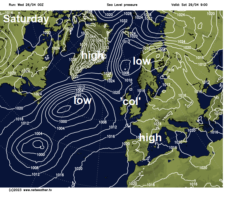
In more detail, the weekend will start with the British Isles in between low pressure over the Atlantic and low pressure over Scandinavia. More technically known as a ‘col’ - the British Isles will lie between two depressions and two anticyclones. The flow tends to be rather slack too, so with little movement of the air milder and moister air in place, there will be a fair bit of cloud around and some showers too.
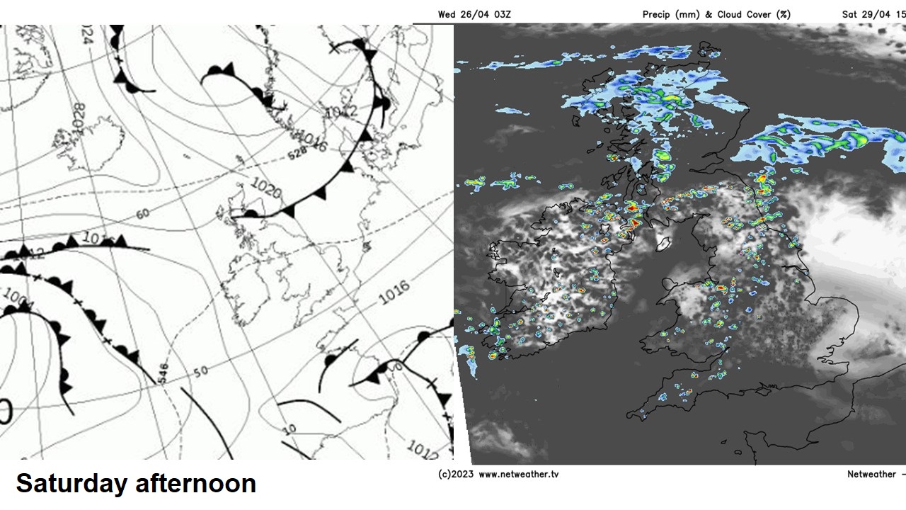
Saturday looks to see a slow-moving weather front draped east-west across Scotland, which will likely bring thicker cloud and patchy outbreaks of rain here through the day. Still quite chilly in the north. Further south across England and Wales, after a cloudy start, cloud breaking up to allow some sunny spells through the afternoon, with temperatures reaching 15-18C. But the sun’s warmth will likely trigger scattered showers across northern England, Wales and the west of England, perhaps locally heavy. East Anglia and SE England look to stay mostly dry and probably seeing the best chance of sunshine and the highest temperatures.
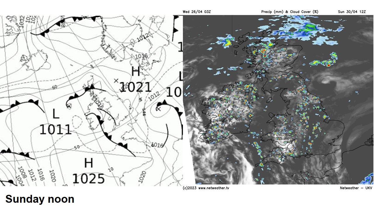
Sunday the weather scene looks a little more complicated, as low pressure to the west over the Atlantic looks to make more of a concerted effort to push fronts and troughs in across the UK, so it looks likely to be cloudy for northern and western areas - with outbreaks of showery rain spreading northeast. After a cloudy start, sunny spells developing across central and southern areas could trigger some heavy showers. Eastern England may stay mostly dry though. It will feel pleasant where the sun comes out though, temperatures again reaching the mid-to-high teens in the south, cooler in the north.
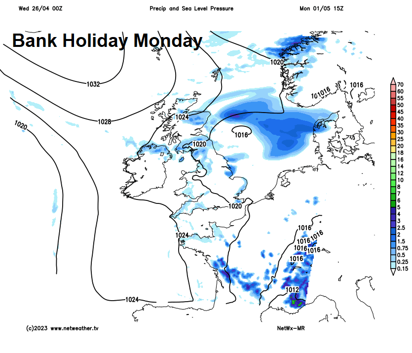
Bank Holiday Monday may see scattered showers in places, though differences between models over extent. Perhaps some rain in the far north to start the day before high pressure builds in from the north bringing drier and sunnier conditions. Otherwise, most areas seeing sunny spells develop after perhaps a cloudy start, but scattered showers developing, perhaps heavy towards SE England. Not as warm as Saturday or Sunday.
Next week looks to see high pressure build from the north, with high pressure likely becoming centred over the North Sea. So other than a few showers perhaps clearing the south on Tuesday morning, it looks to become dry and settled for most for the rest of the week. A breeze from the east or southeast will mean it won’t be overly warm for the start of May, but pleasant enough in the sunshine. Could become quite windy across the southwest later in the week.
But will the fine weather next week last into the Coronation Bank Holiday Weekend?
Well, the models, as would be expected 10 days out, have been chopping and changing between an unsettled weekend, to a mostly fine weekend back to an unsettled weekend. At this range is best to look at ensemble guidance. Best way to do this, I find, is to use the ECMWF ensemble (ENS) cluster scenarios. The charts I use show the clustering of ENS members based on the 500 hPa geopotential forecast fields, the clusters with the most members tend to point to higher probability of a certain scenario.
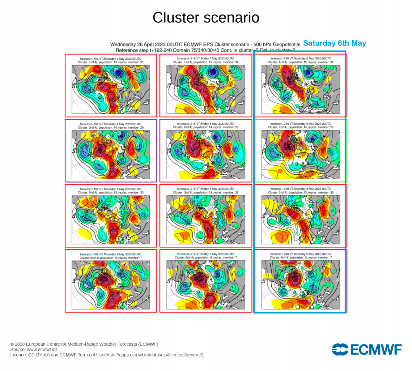
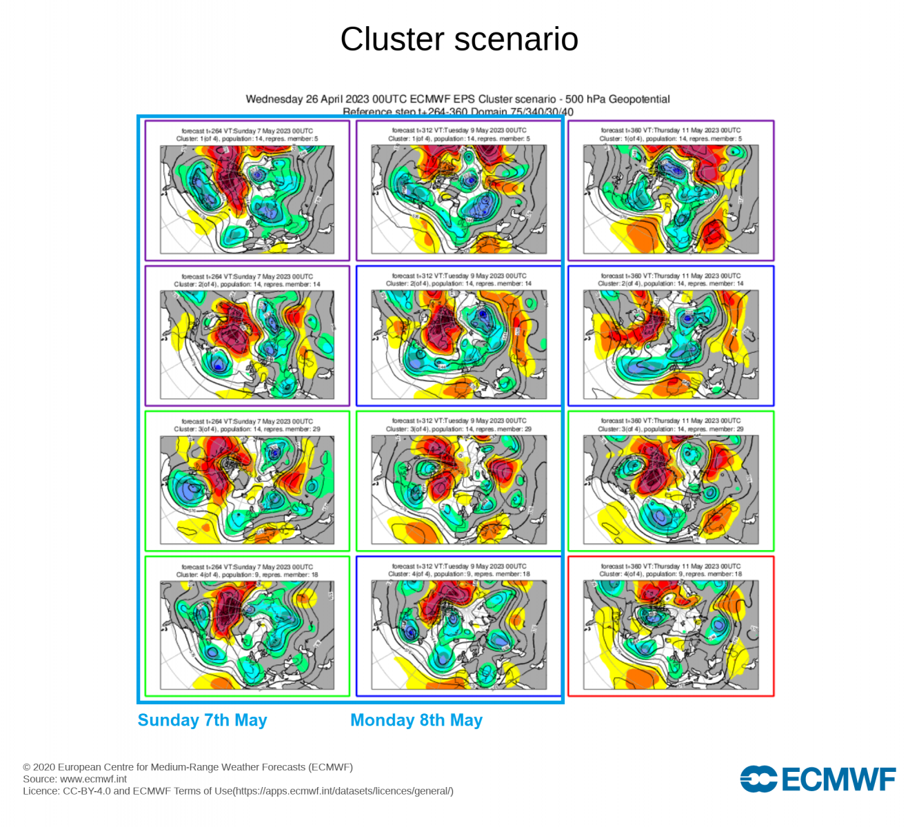
The largest clustering of ENS for Saturday 6th May, clusters 1 and 3 out of 4 representing 28 out of 51 members, suggests upper ridging or high pressure holding on across the UK, promising that the fine weather may still hang on for the start of the weekend, but other members turning unsettled. However, for Sunday 7th and Monday 8th, all 4 clusters show unsettled conditions taking over, as Atlantic troughing/ low pressure extends east across the British Isles. So we could be looking at an increasingly unsettled Coronation Weekend.
But lets hope the King’s Coronation Day will not be as inclement as the late Queen Elizabeth’s coronation day back on the 2nd of June 1953. Unfortunately that day the weather was atrocious. The UK was under a cool and moist northerly flow that day, bringing dully skies, a chilly wind and sporadic outbreaks of rain. The temperature climbed no higher than 12C, colder than it was on the Queen’s wedding day in November six years before!