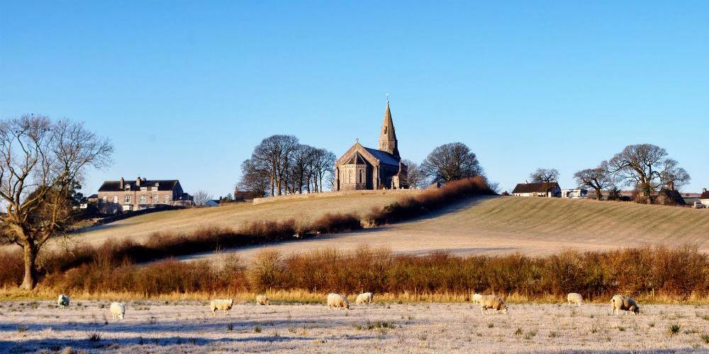
Little or no rain for much of England & Wales looking likely until at least mid-month, this may be a welcome break from the very wet weather last month, but reservoirs in some parts of the UK still need further topping up after drought in 2022.
An old saying goes, "February fill dyke, be black or be it white; Be it white, 'tis better to like." This roughly means that rain and snow are both welcome in February, although snow is preferable. This makes sense because by water filling our ditches, ponds, rivers and streams, it ensures a plentiful and vital supply in our reservoirs and in the ground during the months ahead. By late March, rising temperatures and the trees opening their leaves together dry out the ground so much that little rainfall can seep far underground.
December saw slightly below normal rainfall across the UK overall, with 87% of the average, however there were regional variations – with eastern Scotland and southern England seeing just above normal while western Scotland saw below normal rainfall. England as a whole saw 106% of average rainfall. January saw most of the rainfall during the first half of the month when it was milder, rainfall amounts were quite large locally in this period, but overall, it was a near average month with the drier second half, with 103% of the UK average.
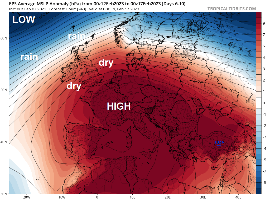
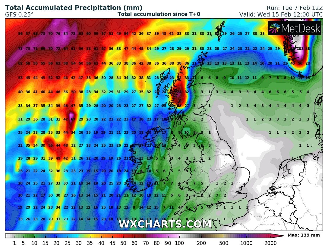
However, it looks like February could see a drier than average first half at least, particularly for England, Wales and eastern Scotland. Several GFS runs, like the most recent below, shows very little rain out until 15th February for the much of the UK, it’s only likely the far northwest, i.e. western Scotland, that could see more than 10mm through to the 15th! This is thanks to high pressure and anticyclonic conditions looking to dominate across England and Wales at least through to mid-month.
Accumulated rainfall until the noon on the 15th Feb - credit: wxcharts.com
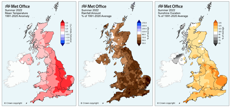
Last year there was little rain in July and August, with June-August 2022 registered as the fifth driest for England & Wales in a series from 1836. By the end of summer, daily river flows were among the lowest ever recorded for some catchments in southern and eastern England, rivalling and sometimes eclipsing those of droughts in 2018, 1995 and 1976. A wet autumn and average rainfall in December and January has seen some recovery following 2022’s rainfall deficit following the exceptionally dry summer. However, across England, there is still some way to go. Current total reservoir storage in SW England is still only 73%. Across the northwest of England total storage is around 88%, across the Midlands 89%, Yorkshire 90%, SE England (Kent / Sussex) 95-100%, Thames Valley around 80% full, groundwater slightly below average. Across the Anglia region reservoirs are 80% full, groundwater below normal. So quite a bit of recovery for most regions, but still below normal in some areas.
February is the 5th wettest month of the year for the UK as-a-whole based on the 1991-2020 climate period. Though for southern England it is the 8th wettest or 5th driest month on average for this period, March, April, May and June drier. February can often be a predominantly westerly month dominated by low pressure, but occasionally anticyclonic conditions can develop, bringing protracted spells of dry weather. Some notably dry Februarys in the past include 1993, 1986, 1959 and 1934.
February 1993 was a very dry month, some parts of the south-west saw only 10% of the average rainfall, Porthcawl in south Wales saw only 4%. Only parts of northwest Scotland reached or exceeded the monthly average.
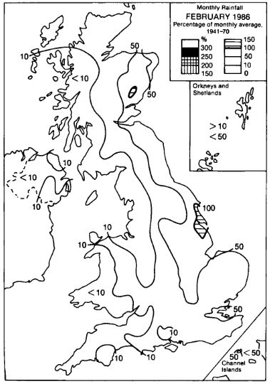
In February 1986 much of the country, away from eastern England and SE Scotland, saw less than half the average rainfall, but it was very dry in the west thanks to easterly winds dominating through much of the month. Rhoose in South Glamorgan only recorded 1mm all month and Manchester Airport only 4mm, making it the second driest February of the 20th century. 1959 was the second driest on record, with only 8mm falling on average across England and Wales, before then there was the notably DRY February of 1934 with only 12 mm of rain on average, a fifth of normal, which ranks it within the 'top-10' driest months.
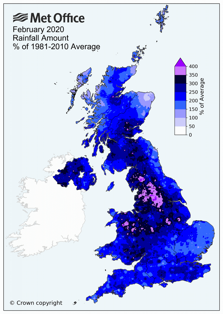
At the other end of the scale from driest to wettest, only a few years back, February 2020 was the UK’s wettest February on record in a series dating back to 1862. England, Wales and Northern Ireland all saw their wettest February on record, with Scotland seeing its second wettest. Overall, the UK had 209.1mm of rain which is 237% of the average for February. This exceeds the previous record of 193.4mm set in February 1990. Rainfall was more than twice the average quite widely across the regions. Some areas, including Lancashire and West Yorkshire, recorded more than three times the average and, locally, some areas saw more than four times their normal February rainfall. There were 3 named storms that month that bumped up rainfall totals, Ciara (7-8 February), Dennis (15-16 February) and Jorge (28-29 February) which resulted in significant daily rainfall extremes for the UK and accounted for about 44% of the February rainfall total.
We may see a change in weather pattern during the second half of February, as La Nina continues to weaken while the Madden Julian Oscillation (MJO), an enhanced wave of tropical convection, looks to move over the Maritime Continent then Western Pacific by mid-month. This can often force changes in the upper flow in the mid-latitudes of the northern hemisphere in winter, by way of energy from the convection pushing poleward and altering the jet stream over the North Pacific and creating changes in pressure over eastern Asia which eventually lead to upper flow changes downstream over the North Atlantic – with a lag of around 10 days. Add to this, it looks increasingly likely that there will be a Sudden Stratospheric Warming between the 16th and 20th, the displacement of the stratospheric polar vortex to Europe caused by the SSW may also cause changes to tropospheric upper flow patterns, including bringing colder conditions, but uncertainty over its effects for now.