There's extreme cold in the northeast of North America but back in the UK, it's mild for now before turning somewhat colder next week with frost and fog. Meanwhile, thanks to that cold in North America, the jet stream will be firing up.
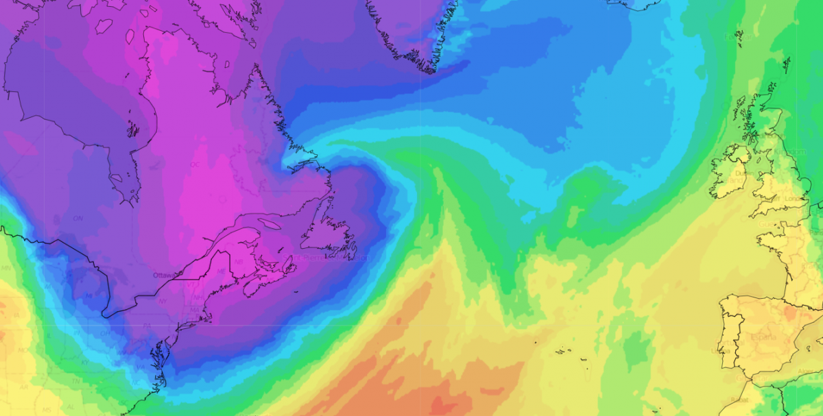
A pool of exceptionally cold air is coming out of Canada and into the north-east of North America, affecting heavily populated areas such as New York, New Jersey and New England. Northern parts of New England have been forecast to see wind chill temperatures of around -45C, giving a major threat of frostbite. Mayor Michelle Wu has declared a cold emergency in Boston. While intense and widely referred to as a "once in a generation cold snap", it will be short-lived, as an area of high pressure moving eastwards across central parts of the USA will shunt the Arctic air out into the North Atlantic and replace it with mild south-westerlies for the north-east of North America.
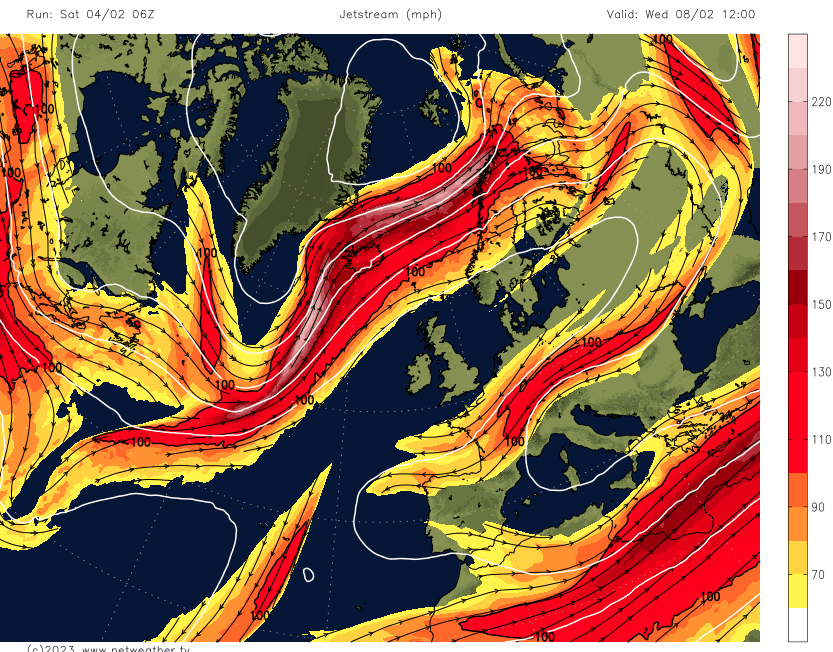
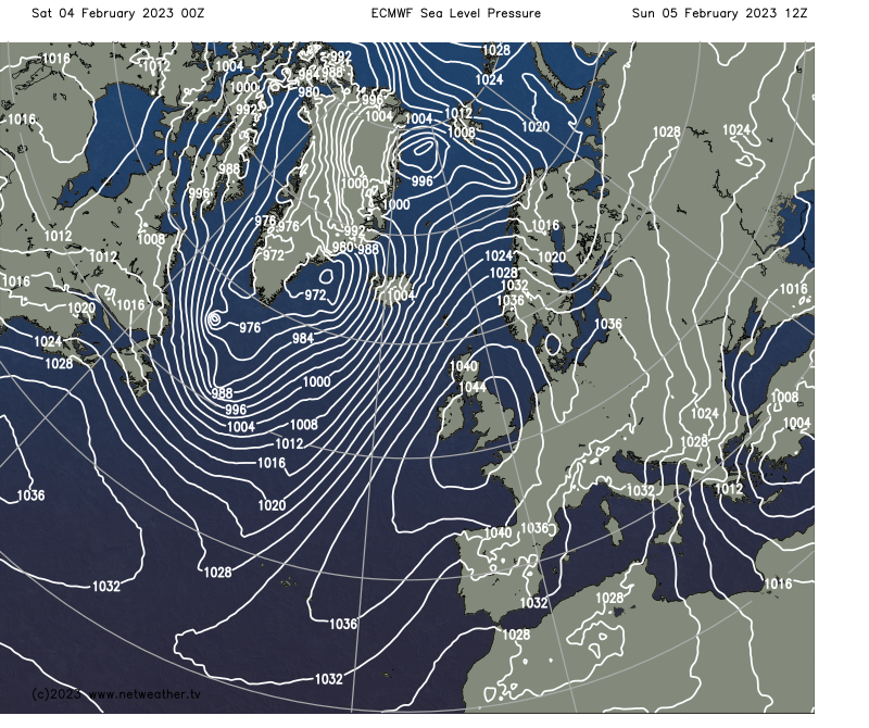
As this exceptionally cold air heads out into the North Atlantic it will power up the jet stream, as the cold air flowing over warm seas and contrasting with surrounding air masses will contribute to cyclogenesis and low pressure systems. However, this will lead to the jet stream running to the north of its usual position, with a strong blocking high developing over Europe, which means that during the coming week the rain-bearing fronts associated with them will mainly be confined to north-west Scotland.
For the rest of the UK, a potentially lengthy dry and settled weather is coming up, with mainly southerly and south-westerly winds on the western flank of the high over eastern Europe. Exceptionally high pressure is forecast to develop over southern Britain on Sunday, with sea level pressure exceeding 1045mb quite widely.
This will be beneficial for many outdoor activities, but will heighten the concerns over the potential for drought conditions to return as we head into spring. The relatively wet weather from mid-October 2022 through to mid-January 2023 has only been sufficient to partly offset the water deficits that resulted from the very dry spring and summer of 2022 in most parts of the country.
Saturday got off to a dry and cloudy start for most, with significant rain confined to the far north-west of Scotland. Some scattered sunny intervals are likely to develop over England and Wales during the rest of the day, but for most places it will remain cloudy. A band of rain will spread south-eastwards through Scotland and Northern Ireland during the afternoon, reaching northern England and north Wales during the evening. Skies will clear to the north and west of the frontal system, with showers for northern Scotland initially, these dying away overnight. These showers will be wintry on high ground. Despite the extensive cloud cover, daytime temperatures will be above the seasonal average, reaching 11 or 12C in most parts of England and Wales and 8 to 10C in most parts of Scotland and Northern Ireland, although northern Scotland will turn colder once the band of rain has cleared.
The rain band will gradually fizzle out as it heads southwards through England and Wales overnight. With clearing skies to the north of it, there will be a widespread ground frost in Scotland, Northern Ireland and northern England, with air temperatures falling very close to freezing. Towards dawn, this frost will extend into much of Wales and the Midlands. It will stay relatively mild in the south, but even here, by dawn, temperatures will generally drop to around 3 or 4C.
Sunday will be a dry and generally sunny day across the UK. Temperatures will be lower, reaching between 6 and 8C in most parts of the country. It will tend to cloud over in Scotland and Northern Ireland during the afternoon and evening, particularly in northern Scotland, but in England and Wales, most places will remain sunny throughout the day.
During next week, it looks probable that the majority of England and Wales will be dry and sunny, with temperatures close to the seasonal average by day (between 6 and 9C in most areas) but often on the cold side by night, with some frost and patchy fog. Daytime temperatures will be cold locally where fog proves slow to clear. In Scotland and Northern Ireland, it will often be cloudier, with daytime temperatures also generally around average for the time of year, but the nights will often be mild due to the cloud cover. Some rain will affect north-west Scotland at times but the rain will tend to fizzle out as it heads southwards and eastwards through Scotland and Northern Ireland. Scotland and Northern Ireland may see some brighter weather around midweek as the south-westerly winds may be replaced by southerlies for a time.