A deep low pressure will bring severe gales and heavy snow to Iceland on Monday night with strong winds reaching Scotland. That low then edges towards Shetland with more windy weather to come.
A winter storm will affect Iceland during Monday night as a deep area of low pressure moves by. There are warnings for severe gales and heavy snow from the Icelandic Met Office. The fronts from this low move across the UK on Monday night. There will be rain for NW Britain and northern parts of Northern Ireland. This is the theme of things this week with rain for this region and particularly western/NW Scotland. Other parts of the UK are mostly dry.
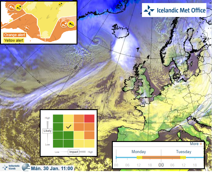
The Icelandic Met Office use a similar traffic light system and Impact matrix in their warnings to the UK
The Inshore Waters forecast around northern Scotland mentions Severe gales and very rough to high seas for Monday night.
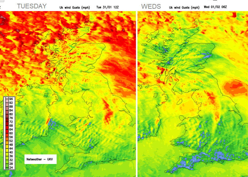
Tuesday itself looks windy in the unstable westerly flow behind the cold front. There will be high lee gusts for eastern Scotland and NE England, with tricky conditions along the A1 and A9. Also, westerly gales for the far north of Scotland and a very windy Tuesday lunchtime for the Northern Isles. There will be a nippy, fresh westerly wind for northern and eastern England, around the Irish Sea, for coastal Northern Ireland and across Scotland. The winds will be strong for exposed coasts and hills with snow showers over the Scottish mountains.
The showers increase over northern Britain on Tuesday evening, falling as rain, hail and hill snow. Northern Ireland and Cumbria will also see showers blown in on the brisk westerly winds.
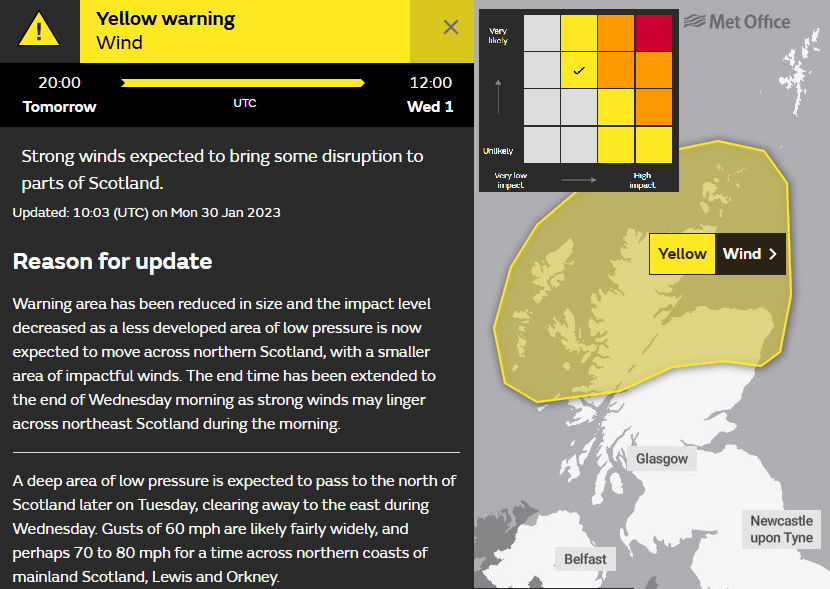
The yellow Wind warning issued by the UK Met Office has been updated. It was across much of Scotland for Tuesday night and early Wednesday. This was almost like a “put a pin in it” exercise, issued on Sunday morning for the week ahead. Now the Monday morning update highlights just northern mainland Scotland and Orkney from Tuesday evening through Wednesday morning.
Inshore Waters outlook for Tues 12Z – Weds 12Z around the Western Isles - Met Office
Wind - Westerly 7 to severe gale 9, increasing storm 10 at times later in north.
Sea state- High, occasionally very high until later west of Lewis, becoming very rough or high later.
Weather - Squally showers, perhaps wintry.
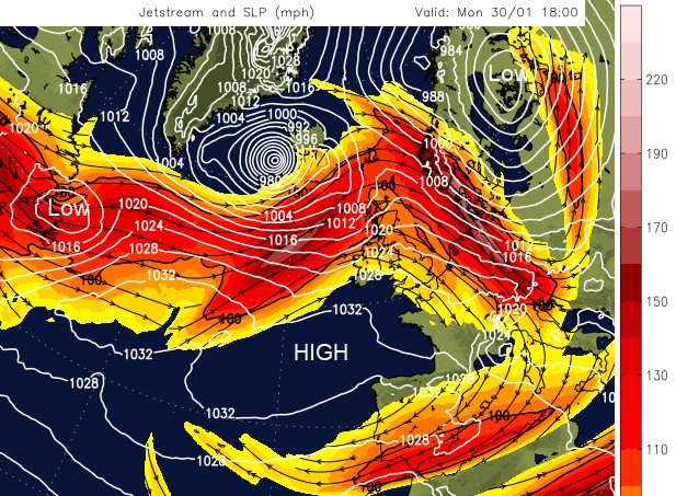
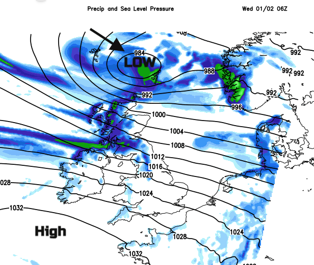
The occluded Icelandic low centre spins down over Shetland on Wednesday morning. The winds veer to a colder north-westerly. It won't be the significant storm of Monday night by then. Currently. the strong jet core is helping to develop the Icelandic low on Monday, deepening in the left exit region and bringing the stormy winter weather to Iceland. However, the ongoing strong winds and gales are likely to have impacts for parts of Scotland in the next few days, particularly the ferry services and along exposed roads and bridges.
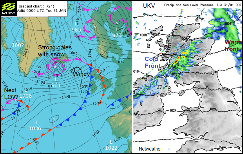
Another low pressure way out west in the Atlantic also arrives on Tuesday night, moving east early on Wednesday across the UK.
This looks to be a flatter feature which will bring a spell of rain and hill snow but not the gales of a developing low. There will be blustery westerly winds for more of the UK by Wednesday.