Severe flooding has affected parts of New Zealand over the past 24 hours, but back in the UK, the weather is quieter with a lot of dry weather to come this weekend. Next week will see a change to less settled conditions though.
In the past 24 hours, Auckland in New Zealand has been hit by widespread flooding due to torrential rain that is said to have given the city around 200mm of rain, 75% of its normal summer rainfall in just 15 hours. Infrastructure and emergency services have been overwhelmed with widespread evacuations, power cuts and traffic queues and accidents. The mayor has declared a state of emergency.
The main culprit has been an area of low pressure sat over the far north of New Zealand's North Island, combined with a warm, humid south-easterly airflow. While New Zealand's prevailing winds are westerlies, it is not unusual, particularly in summer, for the Southern Hemisphere jet stream to track to the south of its usual position, close to the edge of Antarctica, resulting in mainly easterly winds, particularly over the North Island.
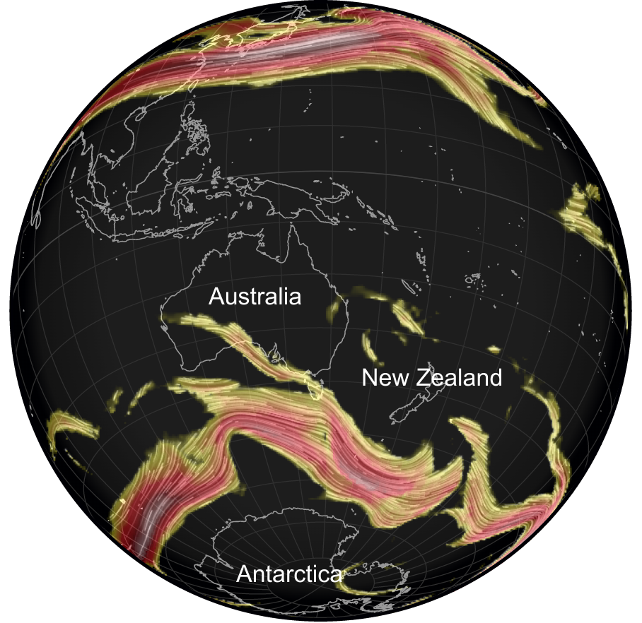
There may be limited relief for a while yet, as current forecast models point towards a blocking anticyclone staying established to the east of New Zealand for much of the coming week, keeping low pressure and frequent rain over the North Island, including the Auckland area.
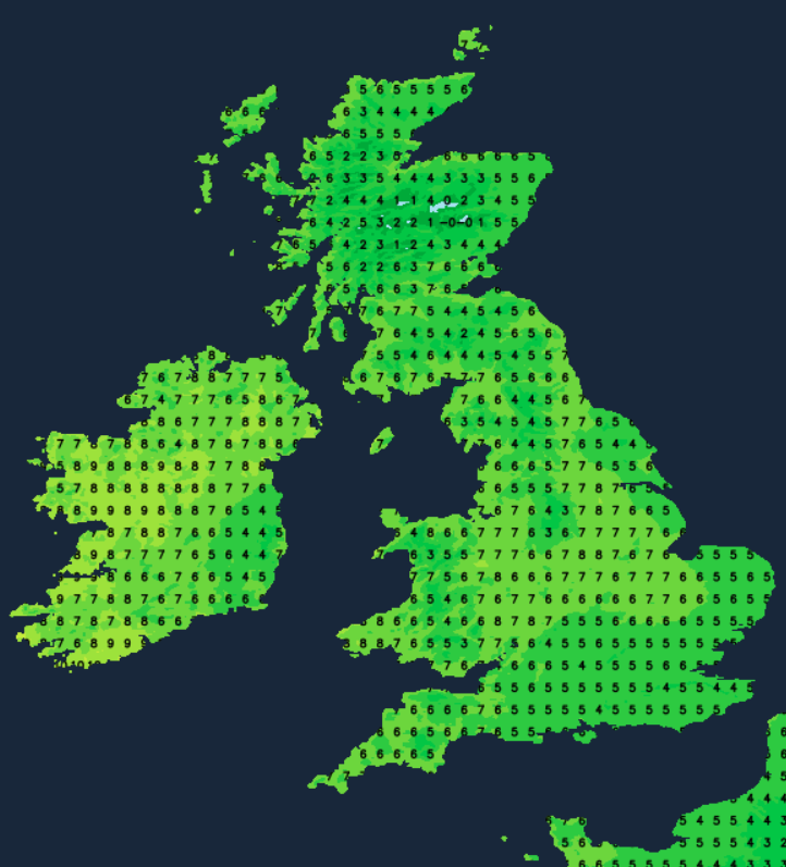
In the UK, in contrast, the weather for many of us has been mostly dry recently, with high pressure holding on in the south. Much of England, Wales and Northern Ireland are cloudy, but we have some sunshine in many parts of Scotland and in a limited area of the Midlands, the Wash and the north of England. It will generally stay cloudy over the majority of England and Wales, but the sunshine is expected to continue over much of Scotland, particularly the east of Scotland, and it also looks set to brighten up somewhat in Northern Ireland. Some of these clear spells may also move into the far north of England. Temperatures will be around where we would normally expect at this time of year, reaching between 6 and 8C in most parts of the country.
During the evening and overnight it will generally cloud over across Scotland, with some outbreaks of rain moving into north-west Scotland. Thus, with a large majority of the country keeping plenty of cloud, it will generally be a mild and frost free night, with temperatures falling no lower than around 3 to 5C. However, where we do see some clear spells, most likely in eastern Scotland and north-east England, temperatures will fall close to freezing under the clear skies and there will be some frost.
Sunday looks set to be another predominantly dry cloudy day in England and Wales, though there is potential for some brighter spells to develop, particularly in the south and east. A band of mainly light rain will spread south-eastwards through Scotland and Northern Ireland, though there may be a narrow band of heavy rain (and snow on high ground) on its northern flank in northern Scotland. This will probably not reach the south of Scotland until evening. Brighter weather with showers will spread into northern Scotland, and these will become wintry inland and on high ground. Temperatures will generally be a little higher than today's, reaching between 8 and 10C in most parts of the UK.
Into next week, the weather will temporarily turn more unsettled with mainly westerly or north-westerly winds, but many areas will be predominantly sunny. Monday looks set to be mainly sunny with a few showers mainly in the north of Scotland. A band of cloud, with associated rain petering out as it spreads south-eastwards, will spread through the country on Monday night and into Tuesday. Tuesday then looks like being another sunny day for most, though showers will be more widespread in northern and western parts of the UK, particularly in Scotland, Northern Ireland and northern England, away from sheltered eastern coastal areas. Showers will also turn wintry on high ground, and also to low levels for a time in Scotland. It has potential to turn very windy in northern and eastern Scotland on Tuesday night into Wednesday.
Towards the end of next week, it looks probable that high pressure will move in from the south-west, turning the weather more settled again.