
The grip of southern cold and frost has gone and next week looks windier with gales in the far north. Temperatures will be back to usual, for January but it will feel chilly when the wind does pickup.
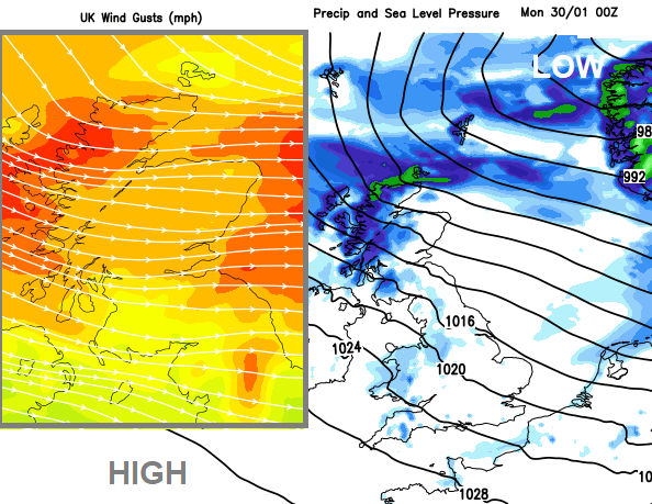
January is a very long month. Even when it seems like it is coming to an end, the 31st still isn't until Tuesday. The UK weather will be stirring as the new week starts with blustery winds, even gales in the far north. The high pressure which brought steady conditions and allowed the cold air and frost over southern Britain to stagnate remains nearby. It lurks away to the southwest for the end of January but looks to build our way in the first few days of February. So windy in between, with more usual January temperatures but that still means some nippy nights, and a bit of frost but kept at bay when the winds pick up. However, in that breeze will feel colder.
There is uncertainty in the forecast around the balance of very windy weather in the far north and the high pressure away to the southwest settling everything down. Northern Scotland will see very windy weather, with frontal rain passing by, sleet and snow over the high ground and high gusts. At times the strong winds and high gusts will affect northern Britain, particularly NE England, the Pennines and eastern Scotland as low pressure pull away. Monday morning, Tuesday and Tuesday night see bouts of strong, gusty winds affecting the northern half of the UK with some wild weather for the Northern Isles, Highland and Grampian.
The jet stream powers out of Northern America where there are extreme cold warnings in Canada thanks to a plunge of Arctic air. This temperature contrast is aiding a stronger jet and a huge frontal system will move across the United States this weekend. There are warnings for heavy snow, dangerous wind chill, heavy rain and flash flooding.
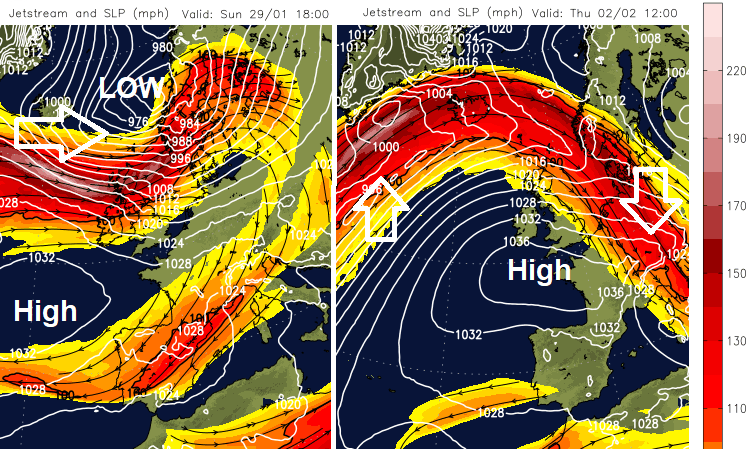
The zonal jet powers across the northern Atlantic with low pressures moving over Iceland to Norway and gradually, a bit further south, we see windier conditions affecting the UK into next week. We haven’t got that surge of Arctic air so don’t expect a lot of snow. At most. there is sleet and hill snow showing in the forecast as cold fronts dangle down from these passing lows, or in showery flows behind the fronts. Here it will feel colder and the showers will turn wintry over high ground. For areas exposed to the northwest flurries might be seen early on Monday and again Tuesday evening. For most places, there will be a lot of dry but bright weather about, although western shores will see rain showers at times.


