A detailed look at the dynamics behind a polar low sweeping south into the North Sea in the next 24 hours, bringing heavy snow showers and blizzard conditions to parts of northern Scotland this evening / tonight.
A polar low looks to bring a short period of enhanced heavy snow showers accompanied by strong winds bringing blizzard conditions and 10-15cm of snow in a short space of time to parts of northern Scotland this afternoon and evening. The polar low looks to have formed yesterday over the Norwegian Sea to the north of Scotland and this morning has tracked south over the Shetland Islands and now the swirl of heavy snow showers associated with the polar low is sweeping down across the far north of Scotland accompanied by gusts of 40-50mph.


The Met Office have issued an Amber Warning between 3pm and midnight for parts of northern Scotland for potential disruption from the heavy snow and high winds. There could even be thundersnow with the heavier showers.
Polar Lows are intense mesoscale cyclones that form at high latitudes in winter and usually found poleward (north) of the main polar front. Polar lows that affect northern Europe often form over the Norwegian or Barents Seas in an arctic northerly flow. They are small, intense low-pressure systems which form in the winter over Arctic waters. With a diameter of 200-600 kilometres, they resemble tropical cyclones but are smaller in extent and intensity.
Polar lows develop when very cold air from the Arctic icecap or cold landmasses flow out over the relatively warmer sea. Drawing heat and moisture from the water, it creates instability and convection characteristic of thunderstorms. With the overlying atmosphere being very cold at depth, the steep lapse rates result in an extremely unstable air mass.
The strong upward motion of air, created by the strong convection in the unstable airmass generates a local area of low pressure at the surface. This in turn generates wind at low levels. In the most unstable conditions, the wind becomes strong enough over a large area to form a vortex which gives rise to a Polar Low.

They often form in regions of strong low-level vorticity, such as troughs, to the west or southwest of a main synoptic area of low pressure. Positive vorticity advection (PVA) plays an important role in the spin up of the low. Today’s polar low formed yesterday over the Norwegian Sea to the southwest of an area of low pressure centred over northern Norway.

Polar lows are accompanied by heavy snow showers and gale force winds bringing blizzards and visibility of less than 100 metres. This kind of weather often creates traffic problems on land, and airports are commonly closed down for periods. Also they are a hazard to shipping and other offshore activities such as oil and gas drilling installations.
Size
The horizontal scale of the polar low is approximately between 200 and 1000 kilometres and surface winds near or above gale force.
Warm core / eye formation
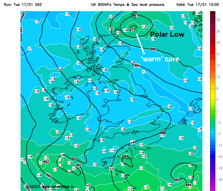
Polar Lows usually form a warm core, where relatively warm air formed from convection is transported to the centre of the low. Today this can be seen as an area of warmer 850 hPa temperatures in the core of the low.
In some cases the inner part of the warm core is cloudless resembling a hurricane eye.
Winds
The term “Polar low” is usually reserved for the most intense Polar mesoscale systems, which have near-surface winds of at least 15 m/s (33.5 mph). Gusts can be much higher than this and can reach hurricane force. Maximum wind speeds associated with polar lows have been recorded reaching 25 to 35 m/s (56-78mph).
If the polar low is moving south, like the one today, generally the strongest winds are found on the western side of the low centre – typically in an area extending 50-100 kilometres from the eye. Kirkwall Airport on Orkney recorded a gust of 54 mph earlier, we could see higher gusts on the western side of the low dropping south to the east of Orkney and NE mainland Scotland this evening.

Strong surface heat flux
The strong winds associated with polar lows can increase the heat transfer from the ocean. Therefore, large surface heat (latent and sensible heat) fluxes, comparable to the ones from mature tropical cyclones, are also a common characteristic of polar lows.
Temperature between sea surface and 500 hPa
If the temperature between the sea surface temperature and 500 hPa level (about 5km up) is 40C or more, then polar low formation is possible due to the steep lapse rates allowing deep convection. Where the low formed over the Norwegian Sea yesterday, SSTs were between 7 and 5C, while 500 hPa tempeatures were between -30 to -40C. So, today’s polar low certainly met that criteria when it formed.


Short life span
A characteristic of polar lows is that they are known to be short-lived features, lasting usually less than two to three days, and to develop quite rapidly, often within 12 hours.
The polar low will track south over the North Sea over the next 24-36 hours reaching the Netherlands and northern Germany coast tomorrow evening, where it may bring gales and heavy wintry showers. The snow showers circulating around the low may clip NE England on its journey south tomorrow.