A look at a powerful winter storm bringing extremely cold arctic air to large parts of the USA at the moment, breaking a few records, with blizzard conditions in the northeast and dangerous live-threatening cold and wind chill into the weekend.
A strengthening winter storm pushing east across the Mid-West and Great Lakes towards southeast Canada today has already unleashed a dangerous flash freeze sweeping south across the Plains and Rockies since Wednesday behind a sharp arctic cold front. The dangerous cold temperatures & strong winds will continue to affect the Rockies, The Plains, the south, Midwest and Great Lakes but also spreading towards the eastern seaboard into Christmas Eve.
Yesterday:
Today
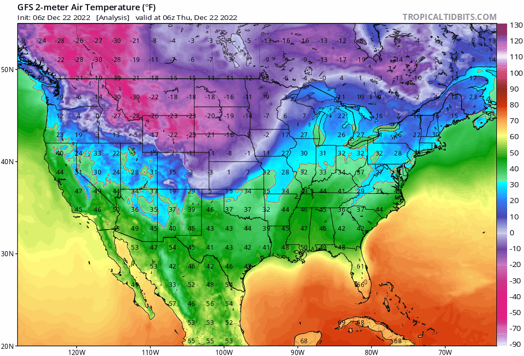
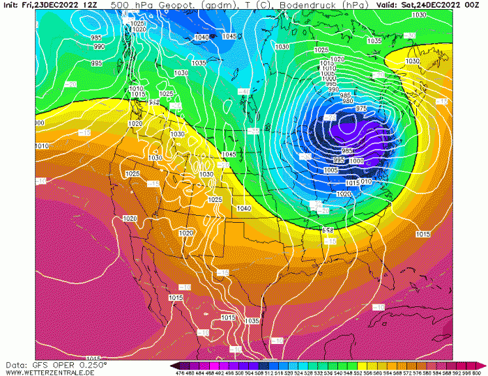
A chunk of the tropospheric polar vortex, that originated over an extremely cold eastern Siberia (where it was -70F), moved over western Canada then dropped southeast into the Northern Plains of the USA on Wednesday.
The vortex was accompanied by a sharp arctic cold front at the surface blasting south, with a temperature drop of 30F in 10-15 minutes recorded in Wyoming as the cold front cleared.
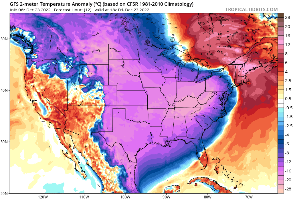
The extreme cold arctic air plunging south and east across the USA since yesterday
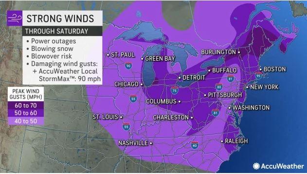
The funnelling effect of winds between intense High pressure along the front range of the Rockies and the cold vortex dropping southeast further east over the Northern Plains strengthened the pressure gradient. This brought sustained northerly winds of 30-40mph and gusts in excess of 50mph On Thursday across the middle third of the USA, bringing extreme wind chill and blizzard conditions in the snow squalls along and behind the arctic cold front sweeping south.
The temperature in Montana early afternoon local time on Thursday fell as low as -50F / -45C, with wind chills of -60F.
Temperatures 40 degrees below average and dangerous life-threatening wind chills as low as 50 degrees below zero continue in the northern Rockies and northern Plains on Friday, with sub-zero to single digit Fahrenheit temperatures likely across the central Plains, Midwest, Great Lakes, Ohio Valley and Midsouth. These well below freezing temperatures extend into the Mid-Atlantic, Northeast and as far south as the Gulf Coast through the Christmas Weekend too, with every state in the continental U.S. experiencing temperatures below 20 degrees on Christmas Eve.
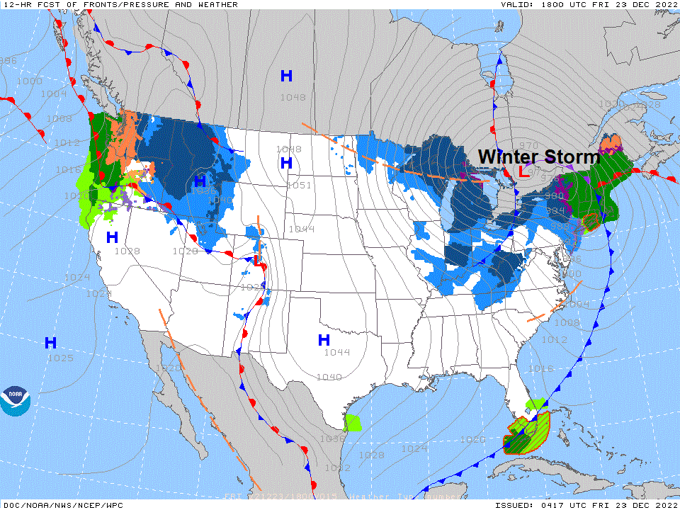
On top of the extreme cold sweeping across the USA, a cold core low will continue to deepen over the Upper Mid-West to Great Lakes today, as arctic-sourced air wraps around the system and the left exit of 150 mph jet streak causes the surface low to rapidly deepen as it moves from the Great Lakes through to Ontario in Canada, deepening to 969mb this evening. The associated arctic cold front sweeps east across the Northeast and mid-Atlantic through tonight. The pressure gradient between the deep low and a 1050mb high drifting east from the northern High Plains will drive intense NW winds across the eastern side of the USA.
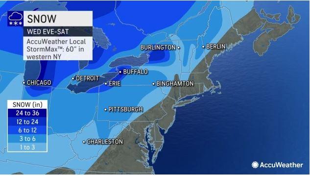
The winter storm will bring Lake Effect snow downwind of the Great Lakes and heavy snow today at high elevations in the Northeast where warm air advection occurs ahead of the arctic front. Winds are forecast to gust between 50 – 70 mph today and into Christmas Eve across the Great Lakes and NE USA, behind the arctic from pushing east as the deepening low moves into Ontario. This will bring blowing snow following the front with near zero visibility, wind chills of -10 to -20F, 25 to 35 inches of snow downwind of Lake Erie and Lake Ontario. The intensity of the cold posing a significant danger to anyone who becomes stranded in blizzard conditions.
Winter weather hazard warnings remain in effect from the Canadian border south to the Rio Grande, Gulf Coast and central Florida Peninsula while spanning from the Pacific Northwest to the Eastern Seaboard.
Travel has already been affected by this storm along with reported power outages. This system will
have increasingly widespread impacts to travel going into the busy holiday
travel time late this week, along with the potential for power outages
from the expected high winds, heavy snows, significant icing and overall
increased power consumption in places. This powerful front allowed
temperatures to plummet 30 to 50+ degrees over a short period for a vast
portion of the country. Widespread record low maximum temperature values
are possible today from the Lower Mississippi Valley, northeastward into
the Tennessee and Ohio Valleys and stretching across large sections of the
east from the Southeast, through the Southern to Central Appalachians and
into the Mid-Atlantic. In addition to the very cold temperatures, highwinds in the wake of the front will produce dangerous wind chill readings across nearly all of the central to eastern U.S.
U.S National Weather Service - Short Range Public Discussion
There's even an IGUANA WATCH for falling Iguanas from trees in Florida because of the extreme cold sweeping down into Florida. The reptiles are cold-blooded, so can't tolerate temperatures below 40F, which are rare in Florida.
However, it will warm up from the west through next week, with temperatures widely above average across the eastern half of the USA by the end of next week. Meanwhile, the extreme cold that is blasting across the USA next few days will spill out over the NW Atlantic, creating a streepening temperature gradient which will fire up the jet stream across the Atlantic towards the UK by the middle of next week, spawning one or two deep lows that could cross the UK. So if you hear stories that the cold in North America is coming our way, it's not true! I's going to mild for most in the run up to the New Year and probably beyond.
Loading recent activity...