A look at the potential for some very warm air spreading up across western Europe next week perhaps bringing an Indian Summer to southern Britain, with temperatures reaching the low 20s Celsius.
There has been increasing confidence from weather model output over the past week for some warm weather on the way next week, with temperatures reaching the low twenties Celsius across southern England. Such a spell of warm weather in October would classify it as an Indian Summer, there’s not strict temperature criteria, other than the Met Office Meteorological Glossary, first published in 1916, defining an Indian summer as 'a warm, calm spell of weather occurring in autumn, especially in October and November.'
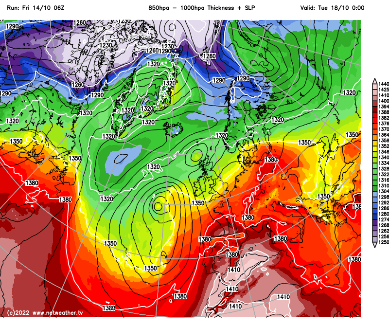
The potential for warm weather next week is thanks to an increasingly amplifying upper flow pattern upstream over North Atlantic, leading to an upper trough to disrupt to form a cut-off upper low to the west of Europe. This upper low to the west combined a strong upper ridge building north over Europe looks to pump a plume of very warm air north from Northwest Africa across western Europe next week, reaching southern Britain by Wednesday.
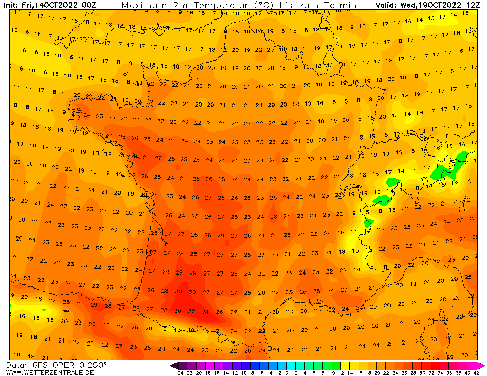
Temperatures are modelled to reach the high 20s or even low 30s Celsius across southwest France and parts of Spain on Wednesday, as the plume of exceptionally warm air spreads north. Across southern England, we could see 20C+.
Yesterday, the American GFS weather model, on one of its operational runs, was showing temperatures reaching 20-21C across SE England on Tuesday, Wednesday and Thursday. This morning, the model has eased off somewhat, with highs reaching the high teens Celsius. Most other operational runs of other model output this morning likewise shows temperatures reaching the high teens next week too. However, some ensemble members of the model outputs this morning in the upper bounds of their ensemble spreads are showing 22-23C.
.jpeg)
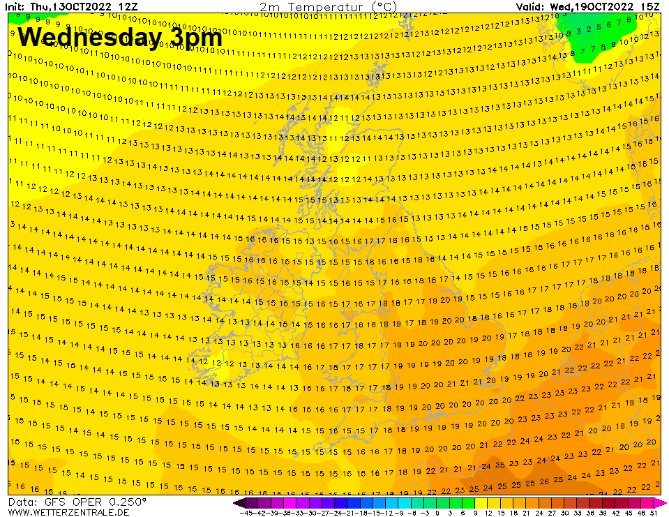
From the 12z GFS operation run yesterday, highs of 21C in southern England next Wednesday:
So, there is potential next week, particularly Tuesday, Wednesday and Thursday, for temperatures to reach the low twenties Celsius across southern Britain with sunshine, most likely across SE England and East Anglia. However, this will depend on cloud cover, wind strength and potential for showers.
Threat of rain / showers and associated cloudier skies makes potential for warm sunshine uncertain when warm air arrives on Wednesday
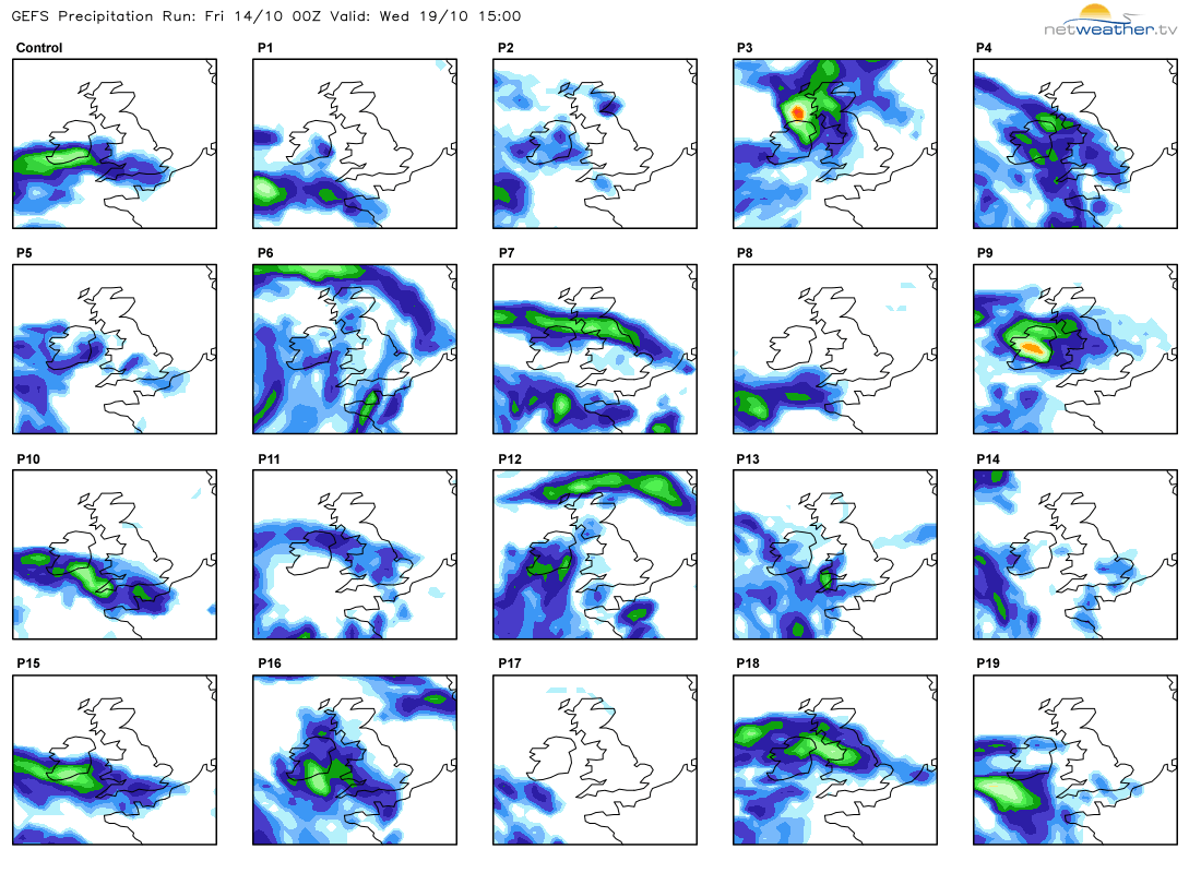
Weather models have been exhibiting uncertainty over the last few days over the positioning and shape of the upper low to the west of Europe in particular, which affects how much the low and its associated fronts and shortwave troughs will affect the UK bringing cloud and showers or longer spells of rain. Should fronts and troughs moving north ahead of the upper low be further west than models show this morning, then there would be less cloud and rain risk and more in the way of sunshine leading to greater potential for temperatures to reach the low twenties Celsius.
Tuesday is looking mostly dry and sunny, thanks to a ridge of high pressure centred over the southern North Sea or Netherlands, temperatures likely reaching the high teens. But its not until Wednesday when higher thicknesses from the very warm plume reach the south, so with sunshine, temperatures may reach 20C or higher. However, at this range, uncertainty how much cloud there’ll be, with some models showing cloud and outbreaks of rain spreading north in the afternoon or evening across the south. There could be further showers on Thursday too, but with the warm air in place and sunshine, temperatures could still reach 20C or more.
Although we’ve seen some chilly nights since the start of the month, the Central England Temperature is currently 1.7C above the rolling average, while most stations in the UK are some 1-2C above the rolling average and with the warmer weather likely next week, it seems likely October could be another above average month, meaning 10 back to back months of above average temperatures.