The past week has seen vivid lightning, flash-floods, shelf clouds and even a few tornadoes. All thanks to low pressure nearby. The troublesome low pulls away this weekend to bring drier weather. But will ex-hurricane Danielle heading towards Europe affect us next week?
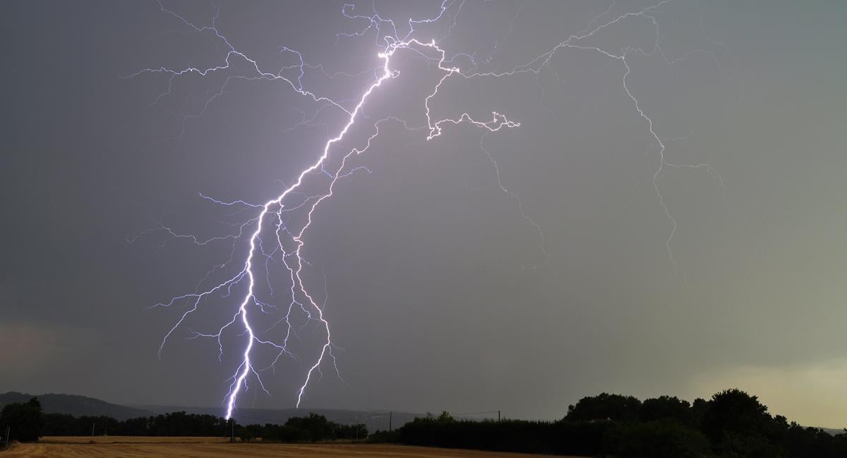
After weeks of the same weather over the summer, i.e. hot, dry and sunny – autumn has certainly changed the record and started with a bang since the weekend. It’s turned rather unsettled, with heavy showers and thunderstorms – some of which have put on spectacular displays of lightning and have even dropped a few tornadoes at different ends of Britain.
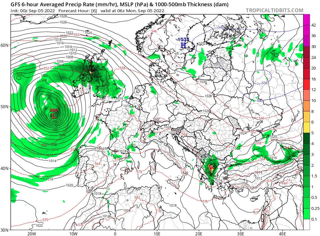
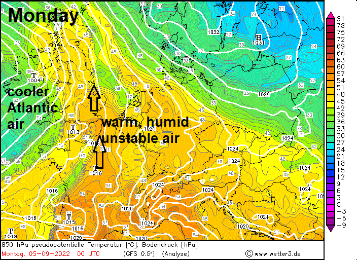
A slow-moving area of low pressure has been parked close to the west of Ireland for much of the week, with bands of showers and thunderstorms spiralling around the low across much of the British Isles. The strongest and most electrically active thunderstorms earlier this week were associated with a plume of warm and moist air that wrapped north and northwest around the eastern flank of the low west of Ireland.
On Sunday and Monday, shortwave troughs rotating around the low engaged the moist plume and brought bands of quite lively thunderstorms northeast across England and Wales. Storms erupting over Dorset and English Channel formed a line of storms which moved northeast across England Sunday night, bringing vivid lightning displays. Then on Monday, a strong line of storms pushed in across SW England and south Wales in the afternoon, bringing torrential rain and even a house was caught on camera struck by lightning in Cornwall. Storms then rolled northeast off the English Channel further east across central southern England early Monday evening, with spectacular shelf clouds observed as the storms arrived along the Dorset coast. The storms then formed a line and pushed northeast across much of England and Wales during Monday evening. A second night of storms for many areas.
The warm and moist plume was pushed away by a cold front out into the North Sea from much of England and Wales by Tuesday, but still lingered across NE England and Scotland – and here saw the liveliest thunderstorms pushing northwest. Thunderstorms developed off the east coast of Scotland during the morning as the warm moist plume streamed in from the southeast over the North Sea destabilising as it moved northwest across eastern Scotland. Then in the afternoon, further south, an area of strong thunderstorms developed along a breeze convergence boundary and pushed northeast from Northumberland across SE Scotland then the Central Belt, a tornado even formed and was spotted with beneath a storm passing just south of Edinburgh in Midlothian.
Wednesday saw low pressure still close to Ireland, centred across the south and continuing to feed in showers across much of the UK and Ireland, the showers organised in bands across northern England in the afternoon, bringing some tricky conditions for the evening commute, while another band of heavy rain and storms gathered over the English Channel early evening before spreading northeast across SE England later in the evening, giving a third or fourth night with storms.
The low finally started to shift slowly eastwards yesterday across southern Britain, bringing further heavy showers and thunderstorms across many areas. Today the low will move across the southern North Sea towards Holland. After a dry start, another day of sunshine and showers developing again today, turning heavy with some thunderstorms - more particularly across England and Wales. Like yesterday, thicker could and more general rain moving in from the east across NE England and southern Scotland.
Low pressure across the south then continues east over the near continent on Saturday but close enough to perhaps support some lingering showers across eastern England, but elsewhere turning drier and brighter as high pressure builds in.
Settling down this weekend as low pressure that's been with us pulls away, though rain threatens the far north and far west later on Sunday
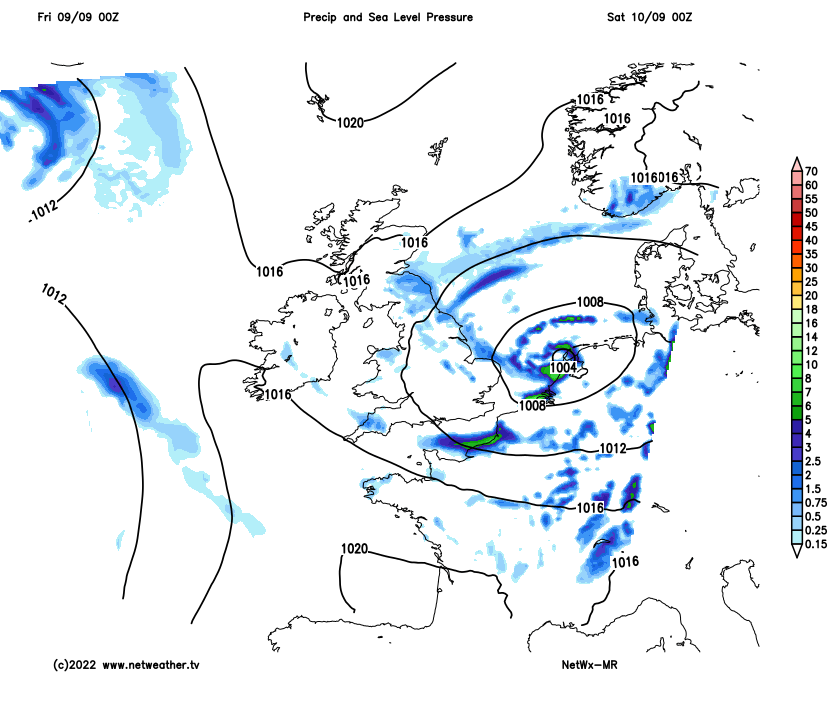
A ridge of high pressure looks to keep much of England dry and bright or sunny on Sunday. But the drier and more settled respite doesn’t look to last in north and far west, with models showing a low moving down from the vicinity of Iceland pushing a band of rain ahead of it towards northern Britain merging with an area of rain pushing up from the southwest across Ireland and western areas of Britain.
The rain pushing up from the southwest will have tropical origins as it is associated with the ex-Hurricane Danielle low moving southeast towards Iberia, so likely to be heavy in places. The computer models had been showing uncertainty where the low containing the remnants of Danielle will wander early next week, but there now appears to be increasing consensus for the low to move into Iberia, but with perhaps a new low forming to the north over the Bay of Biscay.
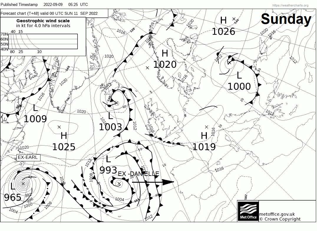
Ahead of the ex-Danielle low moving towards Iberia, a plume of warm and humid air looks to be pulled north towards southern Britain, so on Monday, temperatures could reach the low to mid-20s Celsius towards SE England in the sunshine. Much of southern Britain should stay dry and warm with sunshine, for northern areas a band of rain along a cold front looks to move southeast followed by brighter but showery conditions across Scotland. Cold front looks to continue south towards southern areas on Tuesday, while showers also try and push up from the south. Some uncertainty how much rain or showers will linger across south into mid-week, with GFS showing high pressure building in from the Atlantic at the same time – which could prevent much rain or showery activity developing.
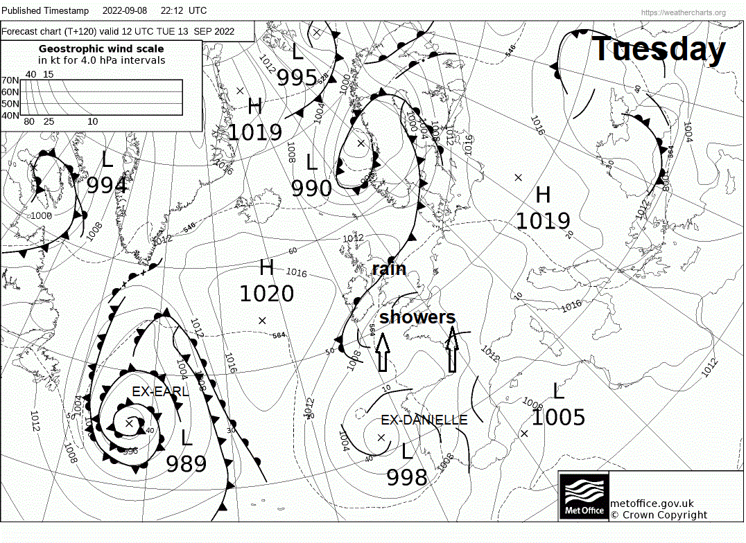
But it does look like the influence of ex-Hurricane Danielle will be fairly muted by high pressure building in across the UK and Ireland next week, with more direct impacts across SW Europe - though could throw some showers towards southern England Tuesday/Wednesday. Category 2 Hurricane Earl this morning looks look to pull away northeast from near Bermuda today, but looks likely it will stay over NW Atlantic as it transitions to an ex-tropical low, before being absorbed by low pressure coming out of Canada. A ridge of high pressure looks to build ahead of it over the NE Atlantic and UK, so maybe a drier more settled middle of month