At least 12 people have died in Italy, Austria and on the French island of Corsica, after violent storms ripped through these areas on Thusday. The storm system developed close to Barcelona Wednesday night, before moving east across the western Mediterranean, ingesting more energy in an area experiencing a ‘marine heatwave’ before crossing Corsica Thursday morning, then Italy and Austria during the day.
Storms started off NE Spain Wednesday night and swept east over Corsica then NE across northern Italy, Austria and Czech Republic:
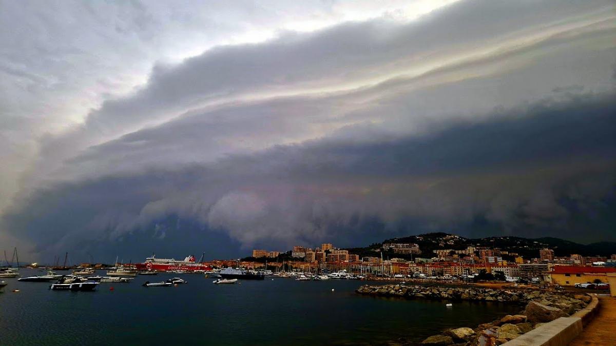
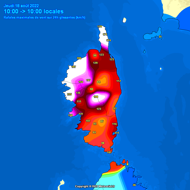
Five people died on the French Mediterranean island of Corsica. A dangerous situation developed between 8:15 and 9:15 a.m. on Thursday in western Corsica when the severe storm system arrived from the west and caused very strong gusts over 200 km / h (124 mph). Marignana weather station in the west of the island measured an exceptional gust of 224 km/h (140mph) – a record for the island. A fisherman and a kayaker died at sea. A 13-year-old girl and 46-year-old man both died in separate incidents from falling trees, while a 72-year-old woman died after being hit by the displaced roof of a hut. Twenty other people were injured, four critically. After 10am the winds weakened as the storm system moved on towards Italy.
The severe storm system then moved east to the northern half of Italy during Thursday, where a man and woman were killed by a falling tree in Tuscany, with multiple people injured and extensive damage to property in northern Italy. Roofs were ripped off houses, trees fell on homes or cars, with extensive blackouts as powerlines were brought down. While flash-floods from the storms also caused chaos in the NW of Italy. The famed St Mark’s Bell Tower in Venice was also damaged by high winds. Below is a video of a Ferris Wheel in the seaside town of Piomboni on the Tuscany coast being violently rocked by 80mph winds as the severe storms struck:
Five people also died as the severe storms moved northeast into Lower Austria. Two girls, 4 and 8 years old, were killed and 13 were injured when trees fell on a lake popular with tourists near the southern city of Graz, while three women were killed by a falling tree that was struck by lightning.
Météo-France, the French national weather agency, seemed to be taken by surprise by the very violent storms which hit Corsica on Thursday morning, They said the event was "difficult to predict" by the numerical forecasting models of Météo-France, defending the meteorological service for not having activated even an orange vigilance warning in advance of the violent storms hitting Corsica that caused several deaths.
Derecho arriving in Corsica on Thusday morning
They said some simulations produced by AROME, the in-house model of Météo-France, "suggested a storm close to that which was observed", while other simulations, "which seemed more likely, located it more at sea,” explained forecaster François Gourand in La Monde, a French newspaper.
Mr Gourand from Meteo-France went on to say that “severe multicellular storm systems, such as occurred over Corsica yesterday morning, occur when certain ingredients come together: managing to predict the combination of these elements is very complicated,” and went on to say: “Very sophisticated models like AROME are able to predict them better and better, but not always”, affirming that meteorologists are “very often in these situations where the models do not make it possible to decide. As often for thunderstorms, there were very significant disparities between the digital models and there was no certainty"
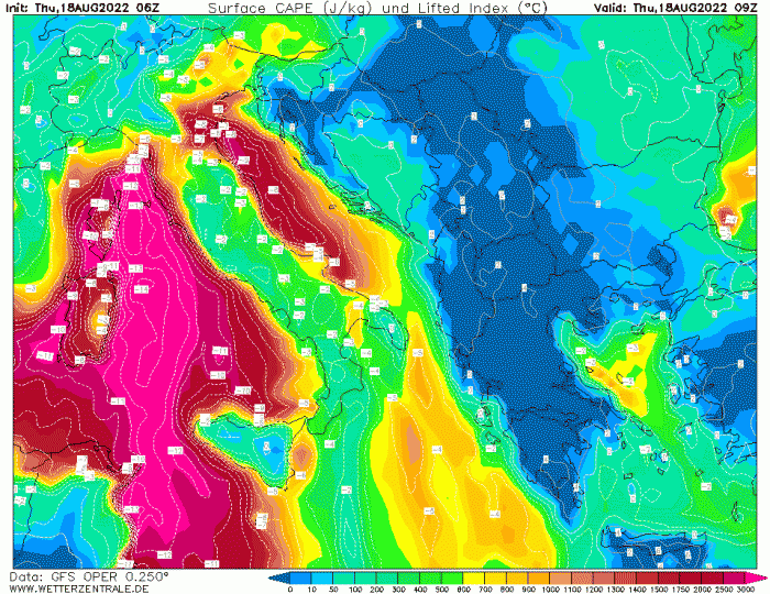
Trough moving in from the NW and strong jet around the trough interacted with steep lapse rates moving out of N Africa and warm/humid air at the surface to produce severe storms over the western and central Mediterranean
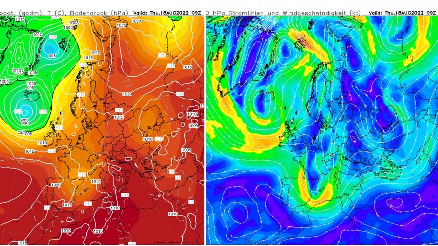
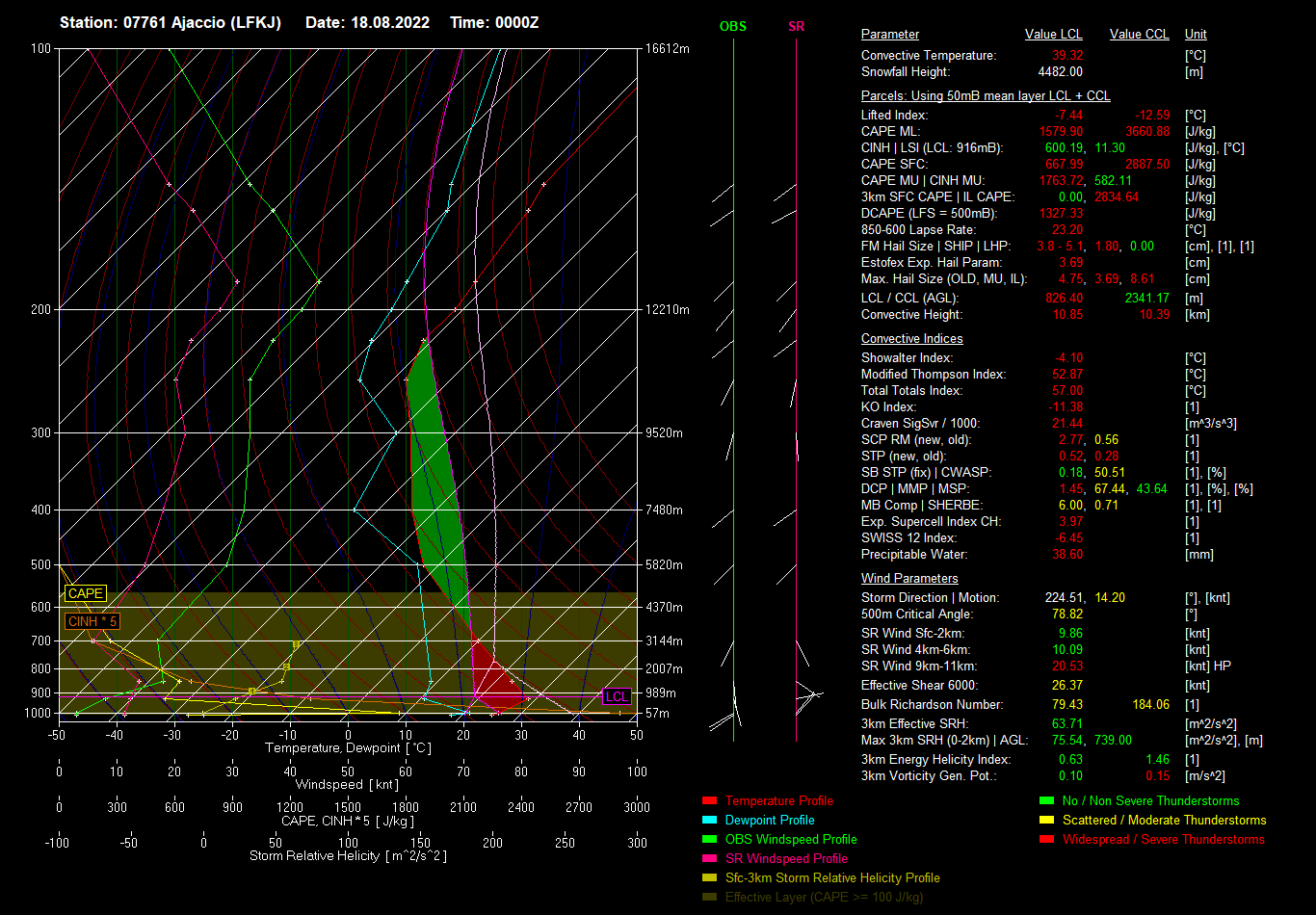
The main ingredients that made these storms so severe were likely the abundant very warm and humid air over the Mediterranean and dry air aloft originating from the Sahara creating very steep lapse rates yielding very large CAPE values. The combination of extreme CAPE, cooling aloft and very strong wind shear, as winds increased with approaching upper trough from the west, set the scene for severe storms to develop and form a Mesoscale Convective System (MCS). Large CAPE values of in excess of 3000 j/kg were modelled over the northern Med, as per GFS chart below on Thursday morning, the radiosonde ascent from Ajaccio on Corsica sampled an atmosphere at midday with 3171 j/kg CAPE.
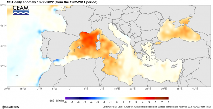
There has been a ‘marine heatwave’ across large parts of the Mediterranean since the beginning of summer, with temperatures in the western Mediterranean as much as 4-5C above average. The warmer the air is the more moisture it holds and also the more rapidly the air rises as pressure falls. So it is likely the marine heatwave, following a very hot summer so far over the region, likely contributed to the severity of the storms.
Sea Surface Temperature anomalies yesterday showed above average SSTs in the western Mediterranean
The rainfall radar signature of the storms complex, known as a Mesoscale Convective System (MCS) in meteorological speak, showed a classic ‘bow echo’ signature. Such storm systems can produce severe straight-line winds and occasionally tornadoes, causing severe damage. Bow echoes are squall lines of thunderstorms and tend to develop when moderate to strong wind shear exists in the lowest 2-3km of the atmosphere, the formation of the bow in the squall line requires a strong elevated rear inflow jet. The processes of convection that create the line of storms also help lower these inflow jet winds to the surface as strong straight-line winds, the stronger the convection the strong these winds can be at the surface. Analysis today of the storm system, see the tweet below and click on translate, suggest it qualifies as a derecho, quite a rare phenomenon, so likely one of the most significant weather events in European history.
The derecho travelled 800km, over 8 countries (Spain, France, Italy, Slovenia, Austria, and Czech Republic). France and Austria seeing the highest fatalities from the storms. Meanwhile, a heatwave grips the Balkans, with temperatures in the high 30s today, with temperatures widely in the 30s across eastern Europe as far north as Estonia and even southern Finland.
Loading recent activity...