There will be showers about on both days but don't rely on a weather app for exact timings. Temperatures will be up in the 20sC before cooling down from the NW to end the weekend.
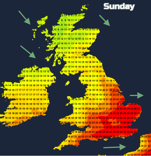
In the next few days, temperatures will be edging upwards. Moving from the high teens/low twenties to mainly 20s Celsius across the UK. This is not the extreme heat of last week but a gradual rise with the peak temperatures edging towards 29, maybe 30C. After that, through the weekend and for early next week they stall. The temperatures stay in the mid 20sC with a fresher feel for Belfast and Glasgow in a westerly flow. Cambridge up to 27C on Sunday.
For much of Britain, there will be a fine, warm Friday evening. Any of the week’s showers will have faded, there will be sunny spells and for southern Britain, inland temperatures still in the mid-twenties Celsius. This is in a light southerly flow but changes are looming from the west. Atlantic fronts will be pushing in through the weekend and the first band of rain will reach Northern Ireland and western Scotland during Friday evening.
The opening ceremony for the Commonwealth Games will be in Birmingham on Thursday. Weekend events include the Marathon in the morning and Cricket on Saturday evening. There will be a weakening frontal band moving southeast across the West Midlands late morning/Saturday lunchtime. So just a few showers and more cloud with temperatures up to 21C and a very light west breeze. Hopefully, this rain will have cleared before the cricket starts with temperatures peaking in the low 20sC. Triathlon and hockey on Sunday on a fresher feeling day with a chance of a shower, after a cloudy start the skies should brighten and temperatures will lift to 23C.
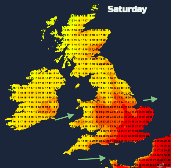
The forecast is rather frustrating for this weekend to pin down detail. It’s not really a time for hanging on weather app timings for rain and dry slots. There will be outbreaks of showery rain moving through. The heaviest will be overnight Friday into Saturday morning with rain for Northern Ireland and Scotland but pulling southeast into northern England and NW Wales early Saturday, still in southern and eastern Scotland before becoming a fragmented band across central Britain late morning. Heavy showers remain for northern UK, mostly dry further south.
Showery rain moves in from the west on Sunday morning but could affect eastern Scotland and NE England more around Sunday lunchtime.
F1 Hungarian Grand Prix at Hungaroring. The 70 laps in Budapest take place on Sunday afternoon. There have been heat and thunderstorm warnings this week. Low pressure develops to the east and the weather looks more unsettled through the weekend. There is the risk of rain, even thunderstorms again and it will bring the temperatures down. They reach 34C in the next few days.
After the Women’s football semi-final, Germany versus France on Wednesday evening the winners of that match will meet England in the UEFA Euro final on Sunday at 5pm. Hopefully, Wembley should be fine and bright. There will be a few showers reaching London during Sunday afternoon, moved along by a moderate west wind. In the sunny spells, temperatures should reach 26C.
It will be noticeably cooler from the north later on Sunday. So if you are off camping and away for Sunday night, know that temperatures will be falling into single figures for inland northern Britain and Northern Ireland with a fresher feeling start for Monday.