Hurricane Agatha hit southern Mexico, its tropical energy added into developments in the Caribbean and Tropical Storm Alex has just passed Bermuda. Next, a deep low could affect NW UK later this week
Later this week there could be some unseasonably windy weather affecting the UK, particularly for the far NW on Friday or Saturday. A significant low pressure will move between Iceland, and Scotland at the weekend bringing hefty showers for parts of the UK and the possibility of June gales. This low has links to two other lows, two tropical cyclones. Tropical Storm Alex which was named near the Bahamas and Hurricane Agatha which hit southern Mexico at the end of May. This does not mean the UK is going to be hit by a hurricane but some of the tropical energy and oomph is still wrapped up in the Atlantic system. There could be strong winds, even gales for western areas later this week.
Hurricane Agatha made landfall as a category two hurricane, “the strongest to hit Mexico's Pacific coast in the month of May since records began in 1949”. The strongest for southern Mexico. 11 people died and more are still missing as torrential rain swept people away in swollen rivers or were buried in landslides. Villages became cut off with roads damaged or blocked and buildings were destroyed.
The NHC had warned “Mexican state of Oaxaca: 10 to 16 inches, with isolated maximum amounts of 20 inches possible. Life-threatening flash flooding and mudslides may occur.”
The terrain inland is mountainous for southern Mexico so Agatha struggled into the start of June. Agatha had formed in the eastern Pacific, the first named storm of that season. After progressing eastwards, the tropical energy was mixed into developments over the Gulf of Mexico, which follows the naming convention of the Atlantic hurricane season. For 2022, the first few names are Alex, Bonnie, Colin, Danielle, Earl, Fiona
As Agatha’s remnants were absorbed into a surface low over SE Mexico new developments were being picked up on the Global model closer to the Caribbean Sea, as heavy rains and “potentially life-threatening flash floods” were being warned of. With strong shear and upper-level interactions, significant development over the Gulf of Mexico looked unlikely. So, there was a pause.
By 2nd June NHC “Satellite imagery, surface observations, and reports from an Air Force Reserve Hurricane Hunter aircraft show that a broad low pressure area is centred over the north-eastern part of the Yucatan Peninsula of Mexico. Due to the possibility that the system could become a tropical storm with impacts in the Florida Keys, and portions of the Florida Peninsula and western Cuba, advisories are initiated on Potential Tropical Cyclone One (PTC1) with tropical storm watches issued for those areas.”
There were warnings for heavy rain but as the “system still does not have a well-defined centre, and for this reason, it is not yet being classified as a tropical cyclone.” NHC
Cuba and Florida were hit by flooding after torrential rain from the system with three people dying in Cuba at the weekend.
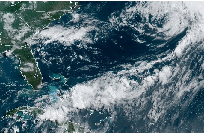
By Sunday 5th the satellite imagery was showing a well -defined centre and PTC1 became Tropical Storm Alex.
“the satellite structure of the storm is hardly classical, with the coldest convective cloud tops all shunted east of the low-level centre which is still occasionally reforming north-eastward where the strongest convection is located.” NHC
It was hard to locate from the satellite imagery at Monday 06Z as Bermuda was under a Tropical Storm warning. A band of strong convection moved through with heavy rain showers and TS winds into Monday but it was already transitioning to a post-tropical cyclone.
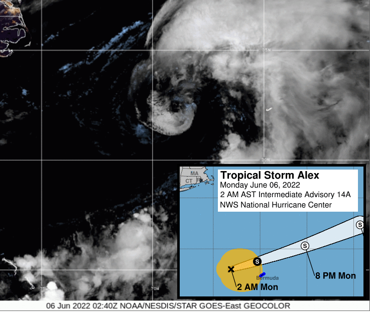
Monday 6th - By 1200Z Bermuda Airport reported a sustained wind of 39 mph with a gust to 59 mph.
NHC “Alex is looking increasingly less like a tropical cyclone and more like a post-tropical entity While the low-level circulation is clearly evident on conventional satellite imagery, it is largely devoid of deep central convection, with the nearest cold cloud tops below -60C located more than 200 nm to the northeast. Those well removed colder cloud tops are forming in response to a digging mid-latitude trough that will ultimately lead to Alex's demise.”
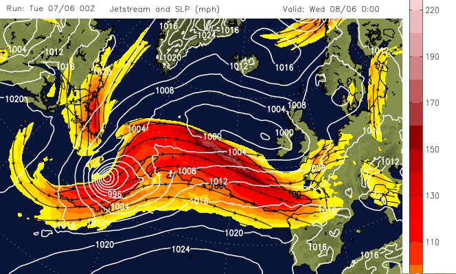
As Alex continues to move east further out into the Atlantic and north into cooler waters it will also interact with a baroclinic zone (A region where a temperature gradient exists on a constant pressure surface). Low pressures that usually move in from the Atlantic to affect the UK and Europe are extratropical cyclones/lows. The GFS and ECM models show another low forming ahead of ex-Alex later this week. This will throw rain across the UK midweek and ex-Alex will get mixed up with that extratropical low, but still out in the north Atlantic.
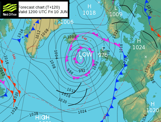
Later on, Thursday a cold front linked to the ex- Alex system will reach Ireland, then be pushed right across the UK, by increasing winds. These are from the main low centre. There is some uncertainty about the developments of the low; how much it will deepen, how close it will get to the UK?
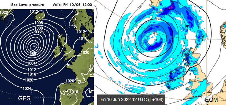
There will be strong winds with gales for exposed coasts and hills of western Scotland and parts of Northern Ireland. By Saturday, there could be severe gales for exposed parts of northern Scotland and potentially a windy start to the weekend for more of Britain and Ireland. Hefty showers tuck in the flow from the northwest for western Scotland and Northern Ireland with the risk of thundery showers and hail too. It’s hardly flaming June, is it?
Top image www.star.nesdis.noaa.gov/GOES June 6th 1230UTC