With a long weekend ahead, a pretty traditional forecast may be for unsettled conditions to dominate, but not this time around.
With a long weekend ahead, a pretty traditional forecast may be for unsettled conditions to dominate, but not this time around. High pressure is set to build as we head into the latter part of this week, bringing plenty of fine, settled weather with it.
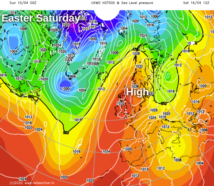
The map below is from the UK Met Office's global model, showing high pressure centred just northeast of the British Isles on Easter Saturday. Other forecasting models follow a similar theme but with some variation from the high being right overhead to it being a little way further northeast. Those small changes could make quite a big difference on the ground - particularly near to eastern coasts where it may be cloudier and cooler should the high sit out to the east or northeast.
As we head deeper into the long weekend, we may need to keep an eye to the west as low pressure could try to bring some less settled conditions our way, but that's a very long way off at this point.
Back at shorter range, there is some unsettled weather to get out of the way before the high starts to build. One other change to start the new working week will be the return of some milder air - particularly across the southern half of the country.
There'll be some showery rain moving northeast through the day on Monday, pushing initially into western England and Wales, before spreading further inland across northern England and later Scotland. Further south and east it'll stay mostly dry though, with some sunny spells. Temperatures in London could reach 18c or thereabouts, and should make it into the teens across much of the rest of England, Wales and southern Scotland, but it'll be cooler further north and near to eastern coasts. It'll be a breezy, if not windy day too, blowing up from the southeast.
More showery rain will move up from the south overnight and into Tuesday, probably merging into a longer spell of rain as it moves north. The wind will become lighter through the day though, allowing England and Wales to see temperatures well up into the teens again, once the rain has cleared through.
The low pressure responsible for the rain should clear away into Wednesday, to leave a day of sunny spells but also scattered sharp showers. We may see highs touching 20c in the southeast, but it'll still be cool with highs in single figures across the north of Scotland.
High pressure will be beginning to build on Thursday and Friday, so there should be a lot of dry, pleasantly warm and settled weather to be had. A weakening front may make a nuisance of itself in some western areas for a time though, with some bits and pieces of rain along with a fair bit of cloud. By Saturday though, many parts are likely to be dry and fine with spells of sunshine.