After a week and coming weekend of warm sunshine across Britain, the models are indicating a cold blast from the north to end the month, feeling more like winter by the middle of next week.
High pressure is in charge of Britain’s and much of northern Europe’s weather over the next 5 to 6 days, bringing dry and settled conditions and some warm sunshine. The anticyclone will be centred to the east of Britain over the North Sea initially today and Wednesday, which will pull in a warm flow from the southeast off the near continent. The centre of the anticyclone will then drift west to be centred over Britain on Thursday and Friday.
Lots of sunshine means that temperatures will reach the mid-to-high teens widely inland across Britain, each day of this week, today and tomorrow seeing temperatures peaking at 19-21C across SE England and East Anglia before highs drop off a few degrees Thursday and Friday.
Today reached 20.7C in Porthmadog in north Wales, 20.5C in Northolt, London - making it the warmest day of the year so far. The average maximum daytime temperature for this time of year is 10C in the north, 13C in the south. It will be warm in the sunshine by day this week, but as often is the case at this time of year, clear skies at night and the dry air means it will turn cold at night, with a risk of frost. So, a large diurnal range of temperatures.
High pressure to east of the UK eventually migrates west this weekend before moving norhwest and potentially opening the arctic floodgates next week:
The fine and dry weather looks to persist through the weekend too, with high pressure centred over Britain, so looking good for Mother’s Day, with dry and sunny conditions in light winds, temperatures reaching the mid-teens inland, perhaps 16-17C in a few spots. But the high’s centre will be drifting west and by early next week, the high is then forecast to migrate to the northwest of Britain towards Iceland and Greenland. This occurring in tandem with an upper trough dropping south from the arctic across Scandinavia – while low pressure systems move southeast over NE Europe as the trough extends south. The high towards Greenland and low pressure over Scandinavia will serve to pull cold arctic air south across Scandinavia but also perhaps further southwest towards Britain by the middle of next week, the last few days of the month.
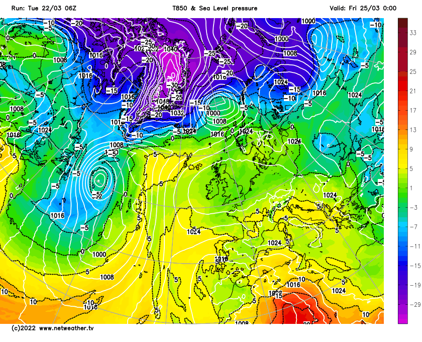
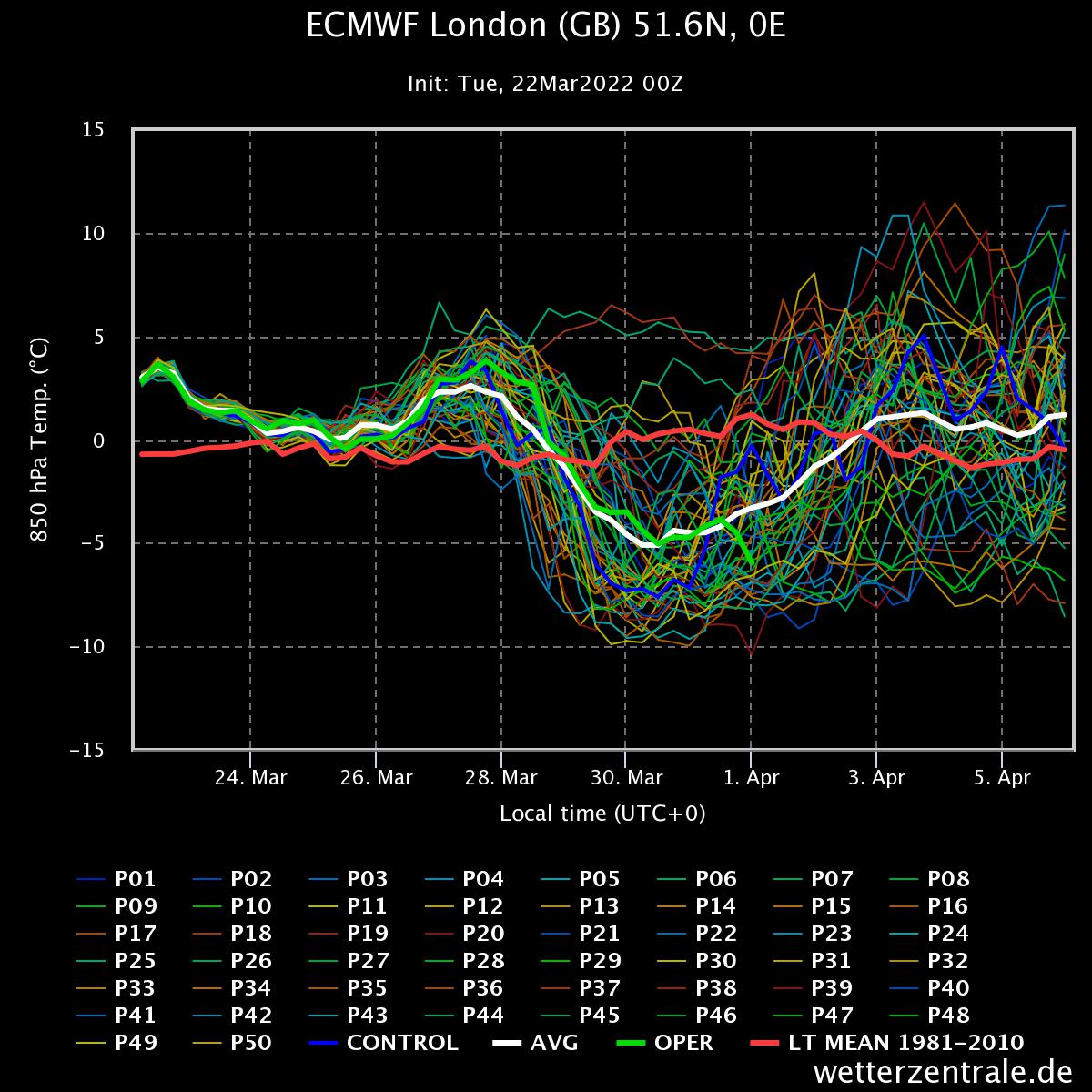
The 00z EPS showed strong support for an incursion of arctic air over Britain by the middle of next week, the mean of the ensemble members has sub -5C 850 hPa arctic air moving in across northern and eastern Britain by Wednesday 30th.
The 00z ECMWF high res run was close to the ensemble mean too which drops to -5C for London at 850 hPa by Wednesday next week.
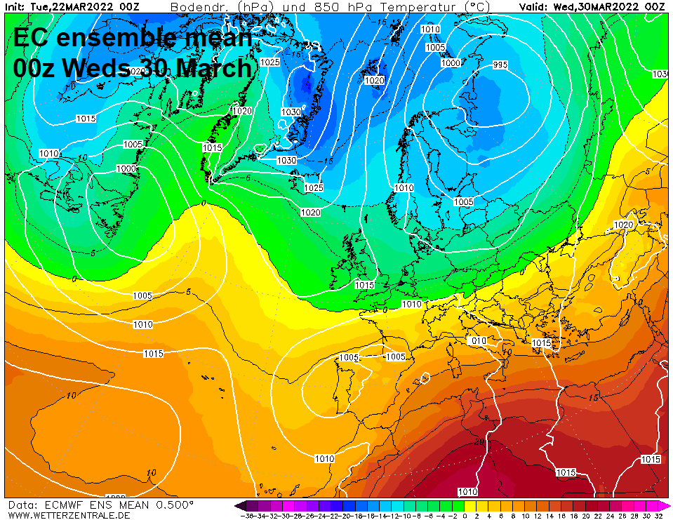
The 00z GEFS mean was not as cold, with sub -5C 850 hPa mean temperature line kept away to the north and northeast of Britain next Wednesday. The 00z GFS high res run did dip colder than the mean for London at 850 hPa next Wednesday, but only briefly touching -5C.
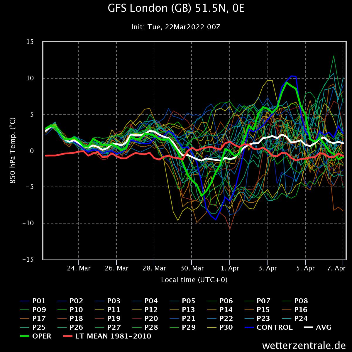
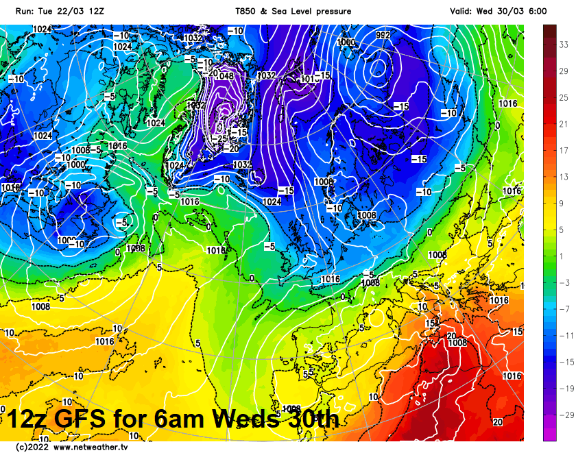
However, the more recent 06z and 12z GFS operational runs are colder for Tuesday and Wednesday next week, the -10C 850 hPa temperature line reaching as far south as Norfolk on Wednesday morning on the 12z run.
So, it looks like high pressure will retreat northwest early next week while pressure falls to the northeast and east, with potential for a cold northerly or northeasterly flow to develop from Tuesday, leading to a cold and unsettled end to the month. But we are still a few days or so away from firming up on how cold it will get to end the month and thus potential for any snow. All depends on how correct the models are this far out on the strength of blocking high pressure building around Greenland and Iceland, how far south and southwest the upper trough extends over NE Europe and far south the jet stream tracks over the Atlantic – all of which will determine how far south and southwest the cold arctic air will reach towards the UK towards the middle and late part of next week. Any cold arctic incursion could be brief, if lows over the Atlantic make more inroads from the west.
If it does transpire as cold as ECWMF this morning and now GFS portrays, it will come as a bit of a shock after we’ve adjusted to the warm spring sunshine on offer this week!