England and Wales dry and sunny today, warm in the southeast. Rain for the far northwest today and more areas on Wednesday. But from Thursday it will turn drier and sunnier across many areas.
Tuesday promises a dry, fine and sunny day for many across England and Wales, while Scotland and N. Ireland will be cloudier, with rain for northern and western Scotland. In contrast, Wednesday will be a cloudier day for England and Wales, with an increasing threat of rain through the day, as one weather front moves up from the south and merges with a cold front moving in from the west. It looks to turn quite wet across central, southern and eastern areas. Fortunately, tomorrow will be the last day of the recent run of changeable weather, as high pressure takes over and controls the weather for rest of the week and through the weekend, bringing dry and increasingly sunny conditions, mild by day but nights will be cold with frost in places.
For now, skies have been mostly clear and winds light overnight across England, Wales and far eastern Scotland, which means it turned cold, so there is a frost to start for some today, especially across northeastern and central areas, temperatures falling to -3C across the Midlands. Cloud moved in from the west across much of northern and western Scotland along with N. Ireland overnight, with outbreaks of rain spreading in across western Scotland.
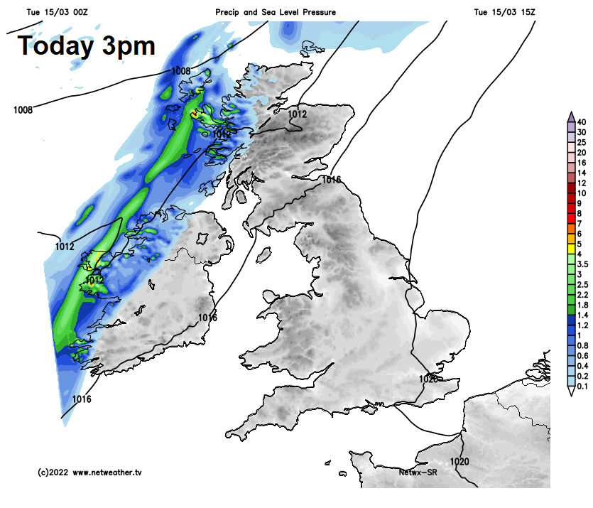
Early showers will clear East Anglia this morning, otherwise England and Wales will remain mostly dry with plenty of sunshine towards the east, patchy cloud and sunny spells towards the west. Scotland and N. Ireland will be cloudier after a bright, cold and locally frosty start across coastal eastern Scotland. Outbreaks of rain will plague northern and western Scotland and increasingly western Northern Ireland for much of the day, not really moving further east.
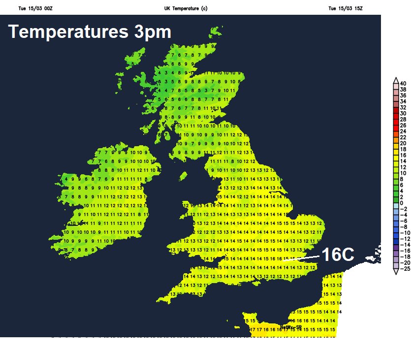
Temperatures reaching a warm 15-16C across SE England, 12-14C elsewhere across England and Wales. Cooler for Scotland and N. Ireland – temperatures reaching 8-10C.
A band of rain will edge eastwards across Scotland and N. Ireland through the evening and overnight, including the central belt, though the far east and southeast of Scotland may stay dry until later in the night. Cooler and clearer conditions following across western Scotland and N. Ireland. England and Wales becoming generally cloudy and milder from the south tonight, with a few showers moving in across southern England and around Irish Sea coasts.
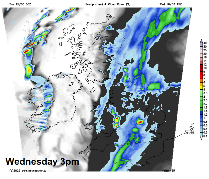
A different picture tomorrow after the dry and mostly sunny day today. There will be a two-pronged attack from frontal wave moving up from the south and a cold front moving in from the west. Increasingly widespread and locally heavy rain will develop from the south across southern, central and eastern England through the day, while a band of rain moves in from the west across Wales, northern and western parts of England while clearing east from Scotland. Brighter, drier and cooler conditions spreading in from the west across Scotland, N. Ireland and eventually west Wales through the afternoon into the early evening, following outbreaks of heavy rain clearing eastern England. Still rather mild across the south, temperatures reaching 11-14C, temperatures falling into the afternoon across the north as the rain clears east, afternoon highs of 6-9C.
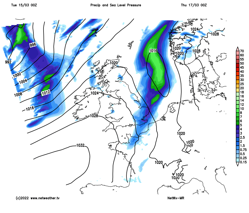
A better day for England and Wales on Thursday, as a ridge of high pressure builds in from the southwest, bringing a dry and sunny day and pleasant in the sunshine. A band of showery rain along a cold front moving in across Scotland and N. Ireland through the day, turning to snow over Scottish mountains – as colder polar air digs in from the west, with wintry showers following across the far northwest.
High pressure builds in from the southwest through Thursday & Friday
Friday sees an area of high pressure drift northeast across the UK and on over the North Sea, so it will be mostly dry and settled, with patchy cloud and a good deal of sunshine for many. Perhaps more in the way of cloud and a few showers across the far north of Scotland.
The weekend’s looking dry and settled too, with high pressure close to the east, though with a brisk southeasterly wind for many. Sunny and mild by day, but with the dry continental airmass, it will turn chilly at night, with a risk of frost. Risk of a few showers spreading north from France across southern areas later on Sunday, but uncertainty this far off.