


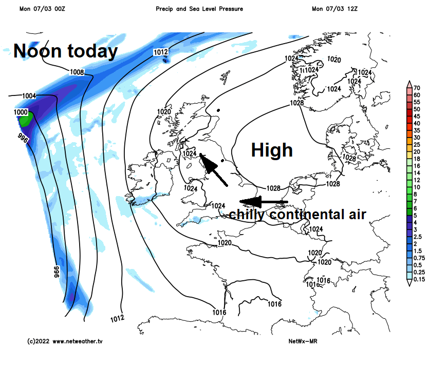
High pressure close to the east will bring another dry, settled but chilly day. But changes afoot from the west, as high pressure retreats to allow Atlantic fronts to move in bringing rain for all by Thursday while turning windy and milder too.
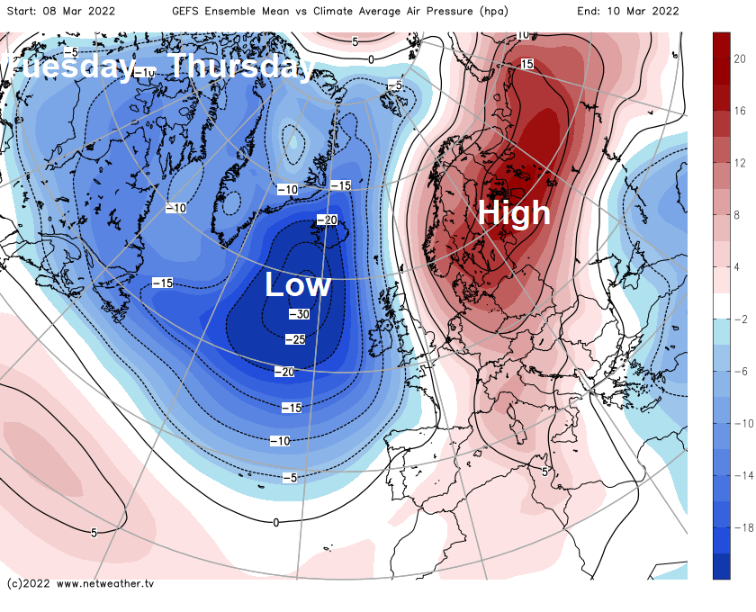
High pressure that’s brought mostly settled conditions over the weekend will be centred over the North Sea today and will continue to feed in a chilly easterly or southeasterly breeze. However, as we go through the first half of the week, the high will retreat over Germany, allowing a milder southerly flow to develop by mid-week, but also allowing wet and windy conditions to move in from the Atlantic across northern and western areas. All parts will become windy and will see spells of rain or showers during the second half of the week, but it will become rather mild too in the southerly flow, perhaps reaching 15C across southern and eastern England on Thursday. The unsettled and windy theme continuing next weekend.
High pressure retreats east by mid-week, allow low pressure with unsettled conditions to move in from the Atlantic
A cold and frosty start for northern areas this morning, temperature fell to -6.6C at Redesdale Camp in Northumberland. A frost in places across the south too overnight, with temperatures falling towards freezing. Blue skies across much of the north this morning, more in the way of cloud and an easterly breeze across Wales and parts of central and southern England, but with increasing amounts of sunshine from the east. Little change through the afternoon, everywhere staying dry, blue skies for the north, patchy cloud and sunny spells across southern areas. Despite the sunshine, temperatures reaching 7-9C at best, thanks to a brisk easterly or southeasterly breeze.
Dry tonight, areas of cloud drifting north at times, but also some long clear spells – which will allow temperatures to fall close to freezing or locally below, leading to a localised frost inland. Temperatures perhaps not quite as low as last night thanks to the southeasterly breeze.
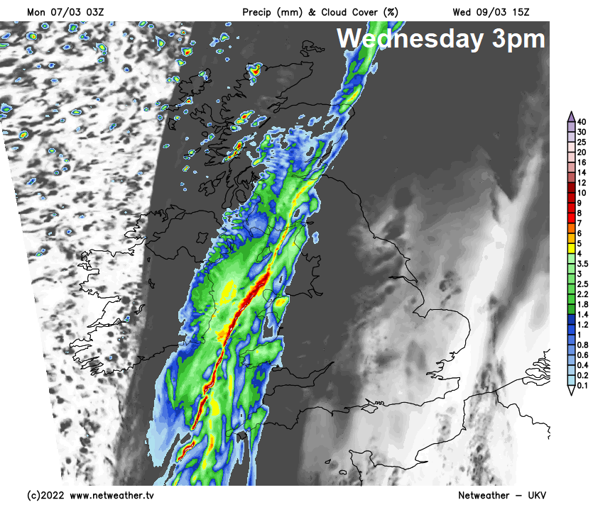
A bright but cold and locally frosty start on Tuesday. Eastern areas staying dry and sunny through much of the day, but after the bright start, clouding over from the west across western areas from late morning, with outbreaks of rain moving in through the afternoon – as a weather front approaches from the west. Turning windy across the west, especially the northwest, a brisk southeasterly breeze elsewhere. Milder, temperatures reaching 8-11C.
Front bringing the rain across the west clearing east during the evening, bringing a spell of rain across the north, but little or no rain along the front as it clears the south
Further wind and rain arriving from the Atlantic across northern and western areas on Wednesday, as an active frontal system moves in from the west. Rain spreading northeast across Scotland and N. Ireland initially during the morning then spreading in across NW England and Wales during the afternoon and lingering here and across Scotland into the evening. Rain locally heavy and persistent, especially over hills, bringing some large rainfall totals by the end of the day. Rain clears N. Ireland to drier and brighter conditions through the afternoon though. Temperatures in the north and west reaching 9-12C.
Southern and eastern England staying mostly dry, bright initially before clouding over in the afternoon, rather mild, temperatures reaching 12-14C. Rain arriving overnight.
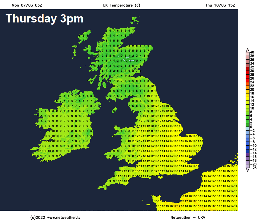
Overnight rain clearing SE England and East Anglia first thing, then it’s looking a mostly cloudy and breezy on Thursday, with some patchy drizzle or light rain in places, especially over hills. Best chance of brightness or sunshine across SE England and East Anglia Rather mild across southern, central and eastern England, we could see 13-15C here with any brightness. Temperatures reaching 8-12C elsewhere.
Windy but still mild on Friday, probably with a band of rain spreading eastward across all parts, followed by sunny spells and blustery showers from the west. It looks to remain unsettled and windy next weekend, with further spells of rain or showers – as areas of low pressure move in from the southwest off the Atlantic.


