High pressure on the near continent will keep England and Wales dry and fine this weekend, Atlantic fronts will keep much of Scotland & N. Ireland cloudy with some rain. Next week will some rain at times, but also some dry and sunny weather.
In contrast to last weekend, when we saw strong winds, heavy rain and hill snow sweep the country then more wind and rain with the arrival of Storm Franklin later on Sunday, high pressure will be in charge this weekend, bringing mostly fine, sunny and settled conditions. The exception will be Northern Ireland and western Scotland, which will be cloudier with some patchy drizzle or light rain at times.
An Atlantic frontal system, bringing a band of rain, will make progress east across all parts early next week, high pressure will be quick to build in from the southwest on Tuesday, before another Atlantic frontal system attempts to move in from the west on Thursday, bringing some rain, but high pressure then rebuilding to end the week.
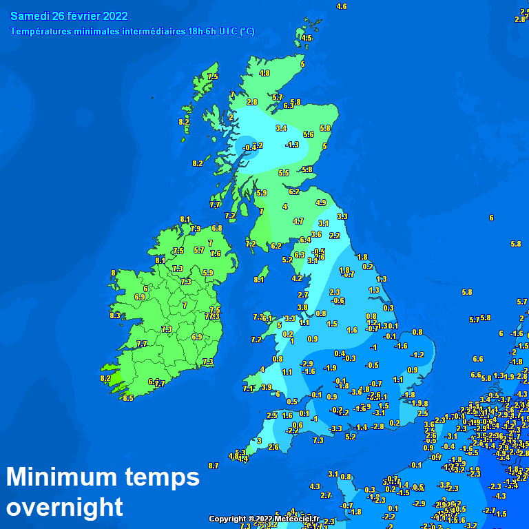
For now, a sunny but cold and frosty start for many across England and Wales, lowest temperatures across central and southern England, Benson in Oxfordshire with the lowest temperature of -3.6C. A milder start for Scotland and N. Ireland with more in the way of cloud and a strong southerly wind, touching gale force across the far northwest of Scotland. Some patchy drizzle or light rain over the Western Highlands and Western Isles.
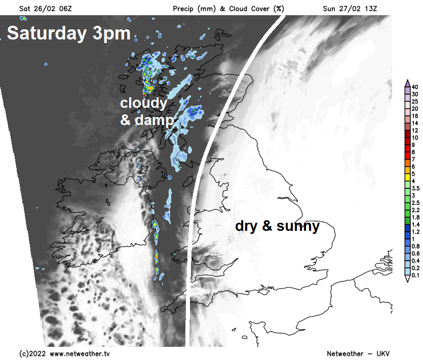
It will remain dry and sunny for much of England and Wales for the rest of daylight hours thanks to high pressure close by over the near continent. Cloudier across much of Scotland and N. Ireland today, with patchy drizzle or light rain at times over western Scotland and N. Ireland. However, there will be some sunny spells to the east and northeast of high ground across eastern Scotland and the Moray Firth. A southerly breeze in the south, strong southerly wind across the north, touching gale force in the far northwest. Temperatures this afternoon reaching 10-12C generally.
Remaining cloudy, windy and generally frost-free across Scotland and N. Ireland overnight, some patchy drizzle in the west before a more organised band of rain moves in across western Scotland in the early hours. Clearer skies for England and Wales, which will lead to another cold night – with a ground frost widespread by dawn.
Band of rain across western Scotland in the early hours fizzling out through the morning, but remaining rather cloudy here and across N. Ireland, with patchy drizzle or light rain. Eastern Scotland together with much of England and Wales will be dry with plenty of sunshine. Temperatures reaching 8-11C generally.
All change though to start next week, as a rather deep low over the Atlantic spins up towards Iceland and pulls a trailing frontal system eastward across the UK during Monday. Some uncertainty over how quickly the frontal system will clear east and where the heaviest rain will be, due to more difficult to forecast ripples developing along the trailing front. But it looks like there will be a spell of persistent and locally heavy rain, accompanied by brisk winds across northern and western areas during the day, as the front moves in. Rain particularly heavy over western hills, which is not good news for rivers flowing from the watersheds of these hills, especially River Severn. The rain band makes slow progress, so unlikely to reach southern and eastern England until after dark, with a dry but increasingly cloudy Monday here.
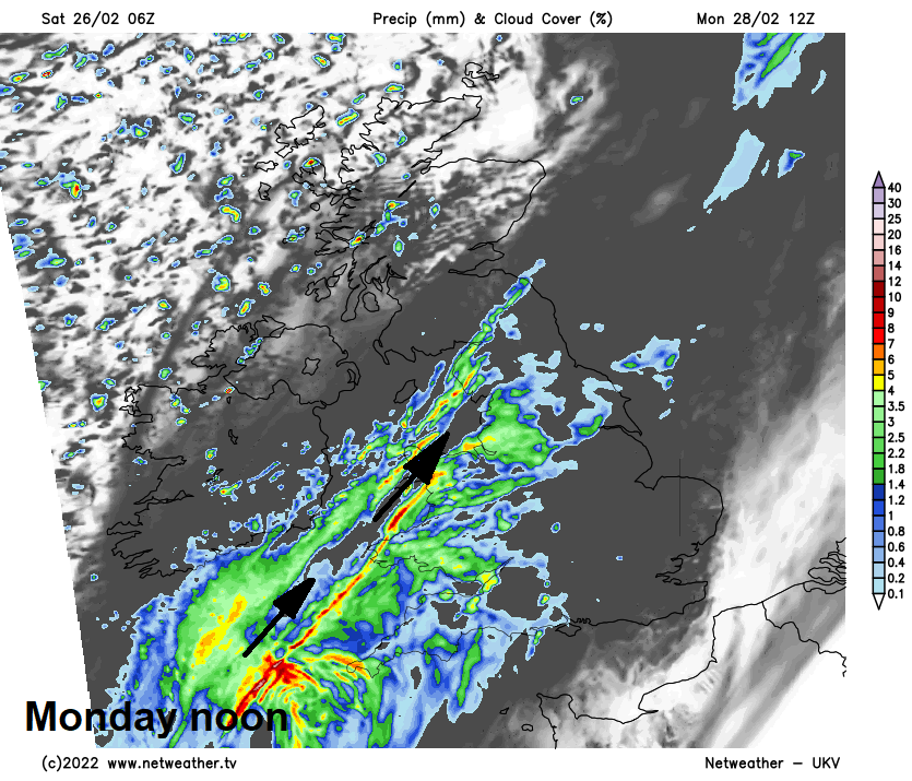
Band of rain clearing east Monday night, but cloud and rain could linger across southern England on Tuesday, as wave or low develops along the trailing cold front. Elsewhere on Tuesday it’s looking a drier and sunnier day with lighter winds, as high pressure builds in. Fairly mild too.
High pressure builds Tuesday, before another Atlantic front moves in Thursday, then high pressure returns to end the week:
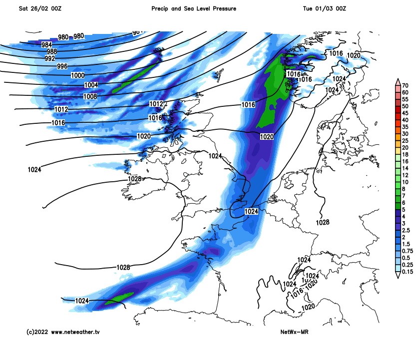
Cloud and rain in the far south fading on Wednesday, but generally a cloudier day in the south and west, with patchy light rain or drizzle over western hills, brighter in the east. Probably cloudier for all on Thursday, with outbreaks of rain spreading east, as a frontal system moves in from the Atlantic. Rain may linger across eastern England for a time Friday, but otherwise becoming drier and brighter, as high pressure rebuilds.