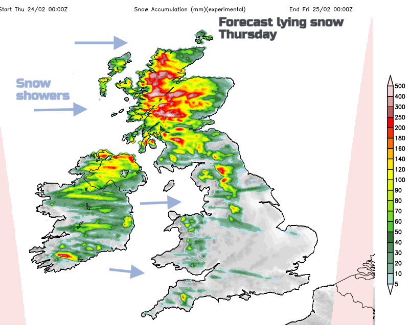
Colder air is on the way. Strong winds will bring snow showers from the west with a warning for NW UK. The weekend is looking drier with sunshine which is good news for flood-hit areas.
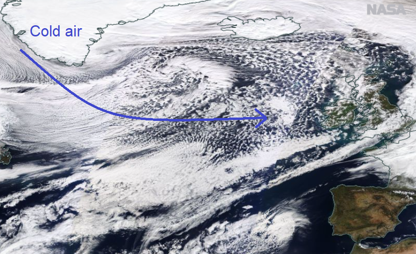
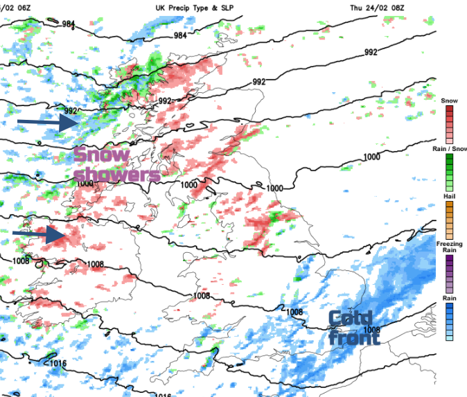
It is turning much colder tonight but looking dry for the weekend. A cold front will creep down over Scotland and Northern Ireland today with heavy rain and mountain snow. Behind this, there is air from Greenland, picking up moisture on its long sea track and producing plenty of snow showers. By Thursday, as the cold front clears southern England, there will be low centres to the north of the UK, throwing off clusters of snow showers on a brief northerly flow straight down from the Arctic.
Warnings have appeared again. Today for SE Scotland into NE England, along the A1 with some restrictions elsewhere on exposed bridges. Then another warning for 'Snow and Lightning' for parts of Scotland and Northern Ireland later today into Thursday.
"Frequent heavy snow showers are expected, along with very gusty winds and a chance of frequent lightning." Met Office
Flood warnings continue this morning with two ongoing severe flood warnings in Shropshire. There are concerns that temporary flood barriers might not hold, and people have been advised to evacuate in case of overtopping.
Bewdley – “There is a danger to life. The temporary barriers at Beales Corner have exceeded their capacity on Tuesday…The level at Bewdley gauge is forecast to reach up to 5.2-5.4m by Wednesday. Levels are forecast to remain high for a prolonged period due to further rainfall this week.” Env.Agency
A bright, fine day with morning sunshine but cloud filling in for England and Wales. Temperatures of 10 to 12C and a moderate to fresh SW wind. The cold front is already bringing rain and wet hill snow to Scotland, from the northwest.
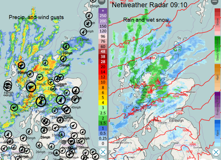
There will be heavy, icy rain as it passes with strong gusts. Reaching Belfast, Glasgow and Aberdeen by lunchtime and Edinburgh early afternoon. Once more a cold front with line convection along it and so a sudden deterioration in conditions with poor visibility on the roads and surface water. Keep an eye on the radar, so you don’t get caught out. It moves into the far north of England later afternoon and then Gwynedd by this evening. Behind is the colder air and a brisk west wind.
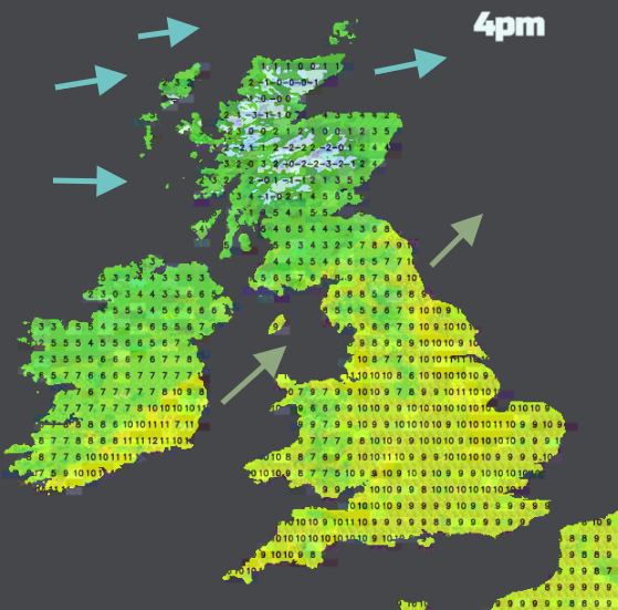
You can see the contrast in the air temperatures by late afternoon. There will be a little snow on the back edge of the cold front for the Pennines and Peak District tonight, but the main focus will be the snow showers piling in from the northwest. Sub-zero inland for the northern half of the UK tonight. Lines and clusters of heavy showers whistling across Scotland and Northern Ireland. Southern Ireland will see plenty overnight too.
The cold front will still be over SE England and East Anglia around dawn on Thursday. It could contain icy rain, even wet snow over the Downs but it edges away eastwards. Behind in the proper cold air there will be heavy snow showers over northern England, again from the west and a mixture of rain, sleet and snow showers for Wales and SW England.
Through the day the westerly winds keep pushing the showers across Britain, so other parts of England could see passing wintry flurries by lunchtime mixed with sunny spells. Temperatures of 5 to 8C but add on the wind. The snow showers and coastal gales keep going into Thursday evening for Scotland and wintry showers for parts of Northern Ireland and NW England including the Pennines. The UKV model shows signs of some invigoration over the Central Belt, through southern Scotland into northern England for the snow shower activity as the winds begin to veer to the north late Thursday. This could bring settling snow to lower levels. Very windy with more snow showers for the Northern Isles and NE Scotland as a low centre clears away early on Friday.
Finally, a nose of high pressure settles the UK weather down with lighter winds and sunshine by Friday. Another vigorous low pressure will affect Iceland and although high pressure holds on for SE UK, the winds from the low will bring a blustery Saturday to Ireland and Scotland but it won’t be as cold. Many parts should be dry this weekend.
(It will be windy, and wintry for some, but no one has officially named Storm Gladys)