A mild few days for much of Wales and England but cold air returns to the north, with snow showers after midweek. The chill spreads southwards with a widespread frost by Friday for the UK
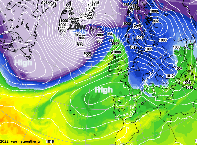
There is a fine but nippy start over Britain this morning, but rain and cloud will move in from the Atlantic with milder air. Topcliffe in North Yorkshire saw a minimum temperature of -4.5°C for Monday morning. UK temperatures will move into double figures within the warm sector. Behind this will come colder and winder conditions linked to a deep low affecting Iceland today. The Icelandic Met Office has issued red weather warnings for southwestern areas and Reykjavik "Southeast severe gale or storm and blizzard conditions"
The frontal boundary then lurks across the centre of the UK until midweek with blustery winds at times. Slowly the cold air from the northwest will take hold across the UK this week as high pressure builds in from the north Atlantic. Most of the precipitation over the next few days will be for NW Scotland and then affect western Britain and Northern Ireland. Southern and eastern parts will see a lot of dry weather. There will be sleet, hail and snow showers in the north as it turns much colder for Thursday night and the start of Friday.
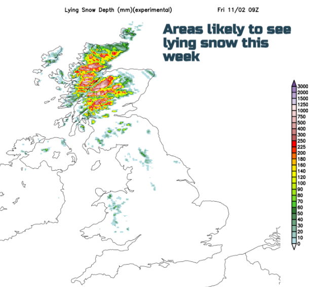
There has been snow for the Scottish Highlands and Islands this weekend. The gritters are out. Snow showers get going once more on Wednesday morning for NW Scotland but working their way down to Strathclyde through the day with flurries possible for Glasgow later. Also, wintery showers will appear for the north coast for Northern Ireland. There will then be heavier snow showers by the early hours of Thursday from the northwest, then north as a small low pressure moves by. That will bring a cold wind and snow to Grampian as the low moves off to southern Norway. As pressure then builds the showers fade on Friday.
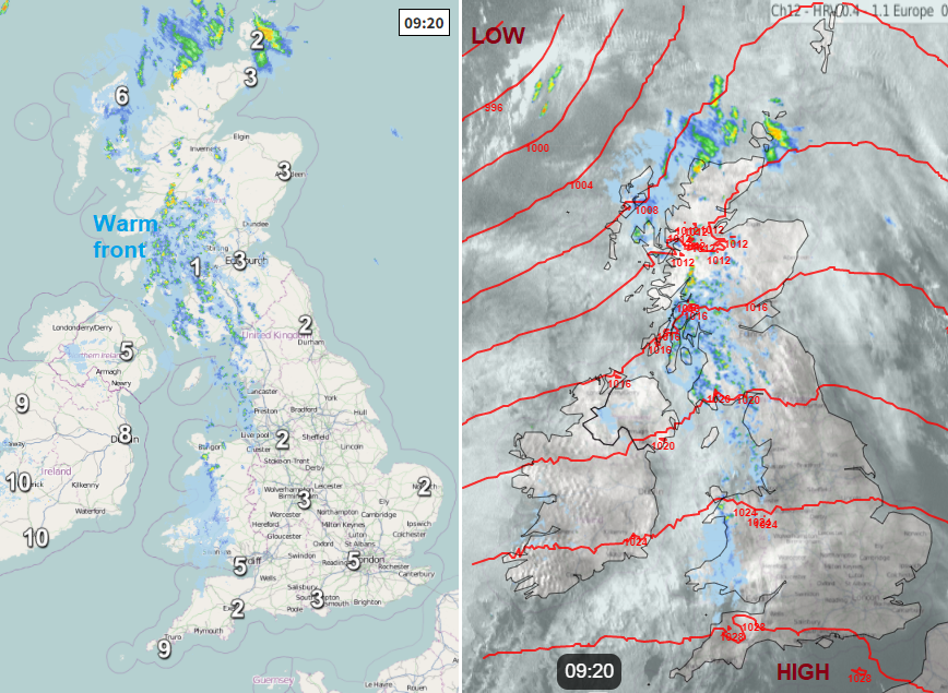
Today the warm front moves through and temperatures rise with cloud reaching right across the UK. There will be rain and western dampness with mountain snow for the Highlands from this. The frontal boundary reaches down through Scotland this evening and overnight, over Northern Ireland and then settling over the Irish Sea and northern England ready for Tuesday morning. The front doesn’t really pep up until Tuesday evening with some heavier rain for Lancashire, Manchester, Merseyside and north Wales.
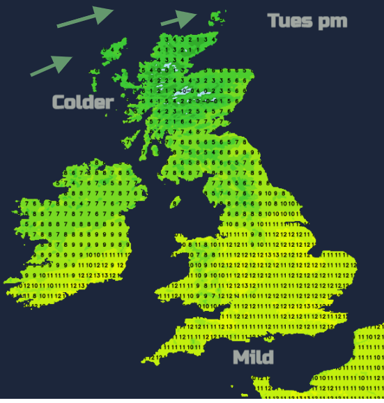
It will be windy in the far north with gales from the southwest then west on Monday. By Tuesday, to the south of the frontal boundary temperatures will start Tuesday at 7 to 10C and should rise to 13C by day. To the north where wintry showers continue to blow in, it will be 0 to 7C early on and rising to around 8C.
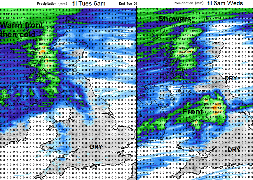
The showers over northern Scotland get heavier with a bit more snow for the hills on Wednesday. The frontal boundary slips southwards with pulses of precipitation nudging in from the southwest. There could be snow over the Welsh mountains for a time early on Thursday before the rain band clears away over SE Britain. By Thursday afternoon the winds will have veered to the northwest and even London will feel cold.
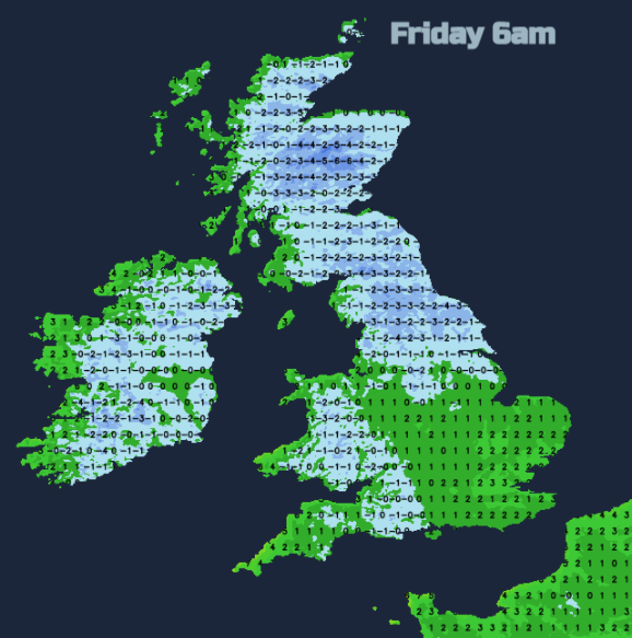
There will be a widespread frost by Friday morning with lighter winds as pressure rises.