


Thursday mild & mostly dry, briefly colder on Friday in a strong northwesterly wind, with wintry showers for the northwest. Turning milder for most over the weekend, windy with cloud and some rain, colder again for Scotland on Sunday.
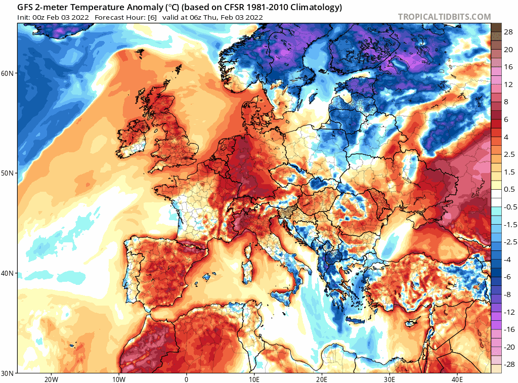
Like the start of last month, it’s been a very mild first few days of February, but that’s set to change briefly by Friday, as colder and windier conditions spread in from the northwest across all parts. Before we get to the colder blast spreading southeast overnight, today will be another mild but rather cloudy day, with patchy drizzle in the west before more persistent rain arrives in NW Scotland this evening. A cold front with a spell of squally rain and hill snow will then sweep southeast across northern areas tonight, before reaching SE England and East Anglia mid-tomorrow morning. Behind the front will be a strong northwesterly wind bringing in clearer and colder polar air – which will feed in wintry showers across the northwest for Friday, mostly dry and sunny elsewhere.
Turning briefly colder for all tomorrow, before milder air floods in from the west on Saturday, though colder air returns to Scotland for a time
The cold polar air is cut off as quickly as it arrives on Saturday, as winds turn southwesterly bringing in milder air, though it will turn colder again for a time across Scotland on Sunday. It will be rather windy throughout the weekend across all parts, with gales around coasts – especially across the north. It will be cloudy for many though, with a wet day for Scotland and N. Ireland on Saturday, before the rain pushes down across England and Wales on Sunday, with colder polar air returning across Scotland, with sunny spells and wintry showers.
For now, a dry, mild but generally cloudy picture for most areas this morning, though there will be some cloud breaks bringing sunny spells towards the east. Some showers will affect the northwest though, particularly western Scotland. A similar picture for England and Wales through the afternoon, mostly dry and cloudy, though some patchy light rain or drizzle over western hills, drier and brighter with occasional sunny spells towards the east. Turning wet and very windy from the northwest with gales developing across Scotland through the afternoon and into the evening, as a band of squally rain along a cold front moves southeast, turning to snow on the back edge over higher ground – as colder polar air undercuts from the northwest. Temperatures reaching 11-12C widely today, though dropping across NW Scotland after the cold front moves through this afternoon.
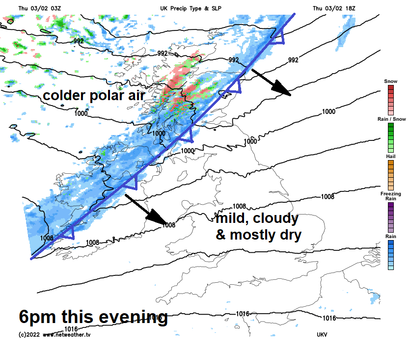
A sharp cold front bringing a squally band of heavy rain with some back edge hill snow, accompanied by gusty winds, will continue to sweep southeast across Scotland and N. Ireland through the evening, reaching northern England and north Wales by midnight. Colder and clearer but still windy conditions following, as winds turn northwesterly. Sleet and snow showers following across NW Scotland overnight, drier and clearer toward eastern and southern Scotland – with a risk of a frost developing in sheltered areas. Mild , dry, but cloudy and windy across southern England and southern East Anglia overnight, squally rain band with some back edge snow reaching south Wales, Midlands to Norfolk in the early hours.
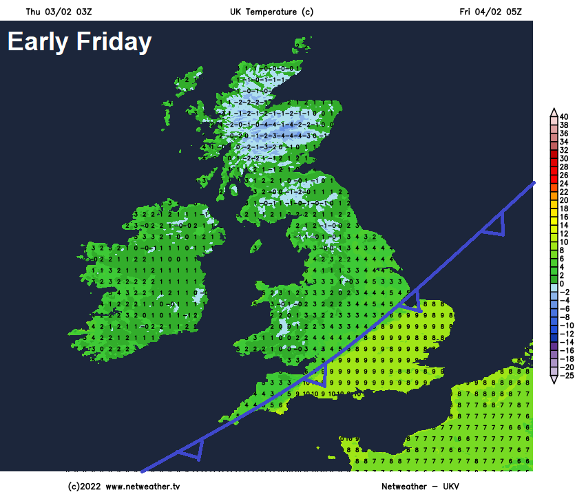
A band of heavy squally rain accompanied by strong wind gusts clearing SE England and southern East Anglia during the morning, to then join all parts to a strong but cold northwesterly flow. Frequent wintry showers, with settling snow over higher ground, will feed in across northern and western Scotland, northern coasts of Northern Ireland, with a few wintry showers getting in across NW England and north Wales too. But elsewhere it will be mostly dry and sunny. Temperatures reaching 5-7C across the north, 7-9C across the south.
.gif)
Less cold but windy on Saturday, the southwesterly wind by then feeding outbreaks of rain in across Scotland, N. Ireland and NW England for much of the day, preceded by hill snow across the Highlands before the cold air of Friday is removed. Mostly cloudy and breezy further south across England and Wales, cloud thick enough for some patchy light rain or drizzle over Welsh hills and moors of SW England. Mostly dry for SE England, Midlands and East Anglia – perhaps with some sunny spells developing too. Temperatures reaching 7-8C across Scotland, 9-11C across England and Wales.
.gif)
Then on Sunday, a cold front will sag south into England and Wales, pushing the rain across Scotland and N. Ireland further south to affect northern England, Wales and the Midlands through the day. The cold front will mark the boundary between mild air across the south and colder polar air returning across Scotland, with sunny spells but also wintry showers across western Scotland.
Milder for all for the first half of next week, often cloud and breezy, with some rain at times for northern and central areas, perhaps reaching the south mid-week. Some uncertainty for the second half, perhaps turning colder from the north following rain clearing the south Wednesday or Thursday, with high pressure building in from the west.


