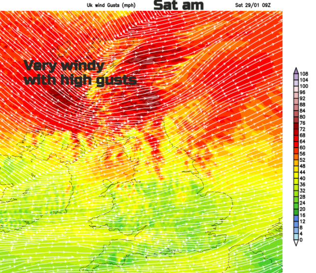
Temperatures will vary wildly this weekend. A sweep of mild air later Friday before a chilly plunge at the weekend. Very windy Saturday morning for northern Britain with rain and Scottish snow by Sunday.
January is coming to an end and for those wanting some decent snow, it has been very disappointing. It’s been dry, had a dreary, dreary part when high pressure subjected us to anticyclonic gloom. Although sunshine data for the UK suggests eastern England has had a much sunnier than average January.
There is a bit of a shakeup this weekend. The high pressure in the south has been getting overpowered in recent days with low pressure skirting past the far north of the UK. We have a quiet start this morning but by Saturday morning there will be strong winds and high gusts, particularly for Scotland. Also, much milder air with temperatures into double figures. However, a cold front will sweep colder air down from the north and the temperatures plummet ready for a nippy start on Sunday.
.png)
Snow
Northern mainland Scotland could see snow on Sunday as a low pressure moves in, up against the cold air. There is some uncertainty about the development and path of this, but also the potential for heavy snowfall to end the weekend over Highland, Moray, Aberdeenshire, Perth & Kinross, maybe into the bordering counties.
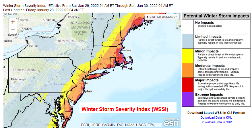
For proper snow and a tricky forecast situations eyes move to the eastern seaboard of the United States. The area likely to see serious snowfall is the heavily populated corridor which includes Philadelphia through New York City to the Boston. This storm, known as a Nor'easter includes a strong wind which has plenty of moisture off the Atlantic coast. The low is forecast to move up the east coast Friday through the weekend and deposit the heavy snow to the west along the coastal counties including the metro areas. There is uncertainty about how close the low will be to land but 20 to 30” of snow is being mentioned. Imagine that.
“A powerful Nor'easter is expected to develop off the Mid-Atlantic coastline on Friday before impacting eastern parts of the Northeast and New England this weekend. “ NWS
As our Sunday low pressure clears the UK, there will be sleet and snow showers pulled down in the cold flow and in the early hours of Monday they could reach northern hills of Northern Ireland, more of western Scotland down into NW England, the Peak District and north Wales. It looks like showers over the far north of Scotland and the Islands will keep a wintry mix next week for the first days of February.
Today
There is mist and fog over eastern and southern Britain this morning where the high pressure holds on with light winds. The quiet start today is quite a contrast to the wild winds of tomorrow. Rain arrives in the far northwest as the winds pickup. So, turning wet for the NW Highlands and Islands. The cloud also increases through the day from the west, but SE Britain will hold onto the sunshine and be rather pleasant. Milder air also edges in and later on the temperatures move from 9C to 10 or 11C. This will feel quite strange.
Various low pressures deepen closer to the UK. One by Saturday morning which heads towards Norway but will bring strong winds and high gusts to northern Britain. There will be gales, even severe gales in exposure. Anyone thinking about hillwalking should take note, including for the Pennines.
It will be very mild with temperatures in double figures until the cold front from this Saturday low pulls south. There will be a dramatic change as the colder air sweeps southwards.
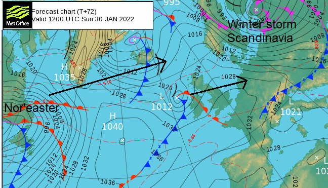
Pressure then rises from the southwest and under clearing skies with lighter winds temperatures fall and there will be a widespread frost. Running into this cold air will be the Sunday Atlantic low, with its uncertainty which could lead to impacts to end the weekend. High winds, heavy rain and Scottish snow are forecast with strong winds and wintry showers still around for Monday morning.