
Warnings for ice and snow in the next few days with coastal flood warnings this morning. The Atlantic will push weather fronts our way but also more cold air.
Quite a contrast from the mild air around New Year to just a few days later. This morning with temperatures widely down between -2 and +3C and Thursday morning looks even colder. There is ice to watch out for today with impacts for Northern Ireland and the West Midlands, up to Greater Manchester and north Wales being highlighted by Met Office in weather warnings for Wednesday.
Back to work and school for Scotland after the extra Bank Holiday and there is snow over the Grampians. There are snow warnings for Thursday and Friday.
Snow may cause some travel disruption over higher routes. Thursday Met Office
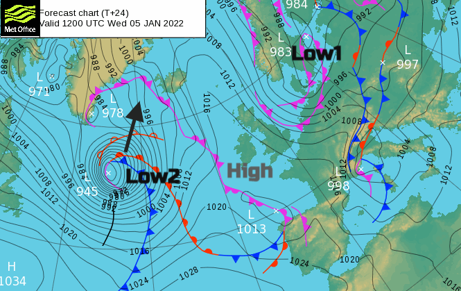
Two low pressures are catching the eye in the next few days. One, to the northeast feeding in those wintry showers, has brought strong winds and cold air right down the North Sea. This low pressure is adding a tidal surge to already high/spring tides and there are various flood alerts for coastal Britain. The North Sea coast has four flood warnings this morning with owners of vulnerable properties being told to activate flood plans and the public take care. The Thames Barrier is also closing again today.
“Waves and spray combined with high tidal levels are forecast to overtop coastal frontages. Please stay away from beaches, promenades, coastal footpaths and roads as the expected large waves and sea spray will be dangerous.” Env Agency
Although the brisk winds ease down today as that first low moves away to the Baltic Sea, the air remains cold. High pressure will build in briefly mid-week and with clear skies there will be a hard frost. The second low pressure will bring a change through Thursday with fresh to strong, southerly winds. This low pressure will develop and head towards Iceland during Wednesday night and there are already warnings here for severe gales and heavy snow.
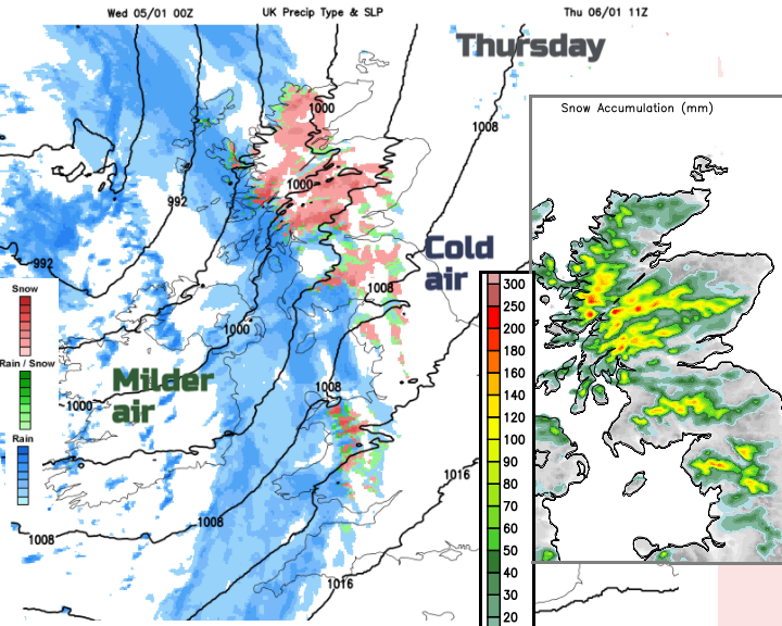
For the UK, the trailing weather fronts will move in from the Atlantic and hit the cold air over Britain on Thursday morning. This will lead to a spell of wind, rain and snow. Behind this, even colder air pushes over the UK and the showery flow from the west will include further sleet and snow. Into Friday there is another Met Office yellow warning for Snow & Ice over NW Britain and parts of Northern Ireland
“Frequent sleet and snow showers may lead to some difficult driving conditions and disruption to travel on Friday morning.” Met Office
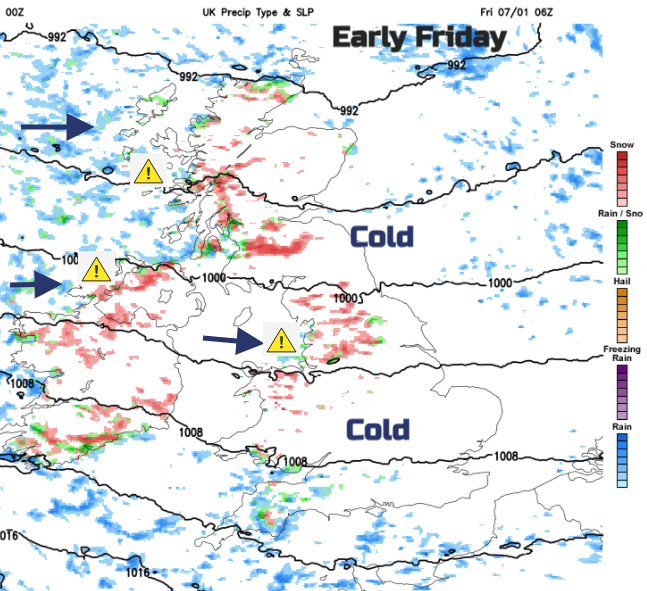
There will be the risk of ice and also fresh show over 200m with 2 to 5cm, even 10cm over the highest ground. Some areas will miss out others see a feed of showers. Gradually through Friday, the showers ease but it remains cold in the north and east. The weather will be changeable through the weekend with spells of frontal rain, hill snow and blustery winds passing by. Leading to milder interludes but then colder times and still a risk of a frost in the north.


