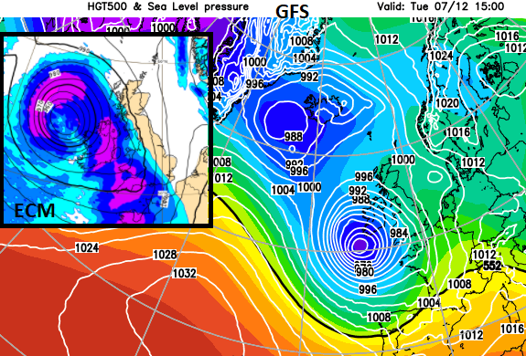
Often cold in the wind this weekend with rain at times and a bit of snow in the mix. Watching developments in the Atlantic next week for a deep low on Tuesday.
The Atlantic continues to throw in low pressures with blasts of cold air from the north following on and then cloudy, wet, milder interludes. A deep low pressure is catching the eye on charts for Tuesday 7th. This being a more usual direction from the west than Storm Arwen with its destructive northerlies, which left thousands without power this week. And some still don’t have any electricity or heating, a week later.
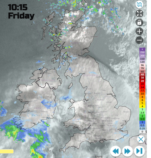
Milder air clips the south coast of Britain today as more rain arrives for Cornwall, Devon and the Channel Islands this afternoon. It is colder further north and temperatures vary from 7 to 11C for Friday. This frontal rain glides eastwards around a developing low pressure as another low heads into NW Scotland by midnight. Its cold front will then sweep right across the UK with colder air everywhere for Saturday. This remains bringing wintry showers in from the north-west with snow for northern hills. Even colder air reaches the far north of Scotland during Saturday night bringing snow to low levels for the far north of mainland Scotland by early Sunday. The cold wind begins to ease but still noticeable and chilling for eastern England.
The cold north winds, frosts even snow of recent days has been quite a contrast to November which was overall so mild. The UK Met Office has released provisional figures which show that Autumn 2021 was the warmest on record for Northern Ireland and third warmest for the UK.
Temperatures this weekend will be 5 to 8C by day and although mild for southern Britain on Friday night it will feel colder everywhere for Saturday night. Closer to freezing with a frost inland for Scotland and Northern Ireland where the winds will fall light.
There will be an area of rain working its way across southern counties of En Gland later today. This frontal system also will affect the Channel Islands where it will be windy. Heavy showers continue to feed into NW UK with wintriness over the high ground. Through the night more push eastwards over Northern Ireland into western Britain with hail and icy rain.
This wet weather on the cold front will be clearing East Anglia and SE England on Saturday morning with the wrapped round occlusion bringing wet and wintry conditions to Scotland, Northern Ireland, NW England and down through the Cheshire Gap.
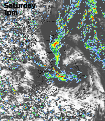
This swirl of wet weather with wet snow for the hills continue to edge eastwards as more heavy showers are brought down from the northwest. It will feel cold in the wind.
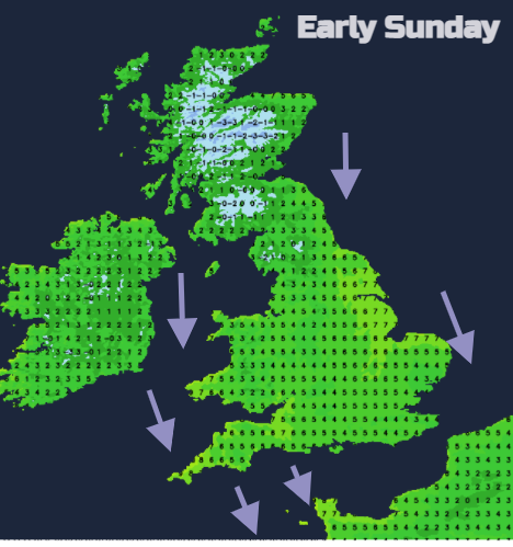
This showery feed on a cold north wind continues for eastern Britain on Sunday morning but with more settled, fair conditions further west. Pressure will be building here so a better end to the weekend.
A frontal system moves in from the Atlantic on Monday, with a brief warm sector, more cloud and rain. As this hits the cold air ahead of it, there could be snow for a time, particularly but not exclusively over northern hills. Then a quieter lull before we see what the Tuesday deep low brings to the UK. There could be gales, high gusts, heavy rain and even snow.