The weather is on the change this weekend as winds swing into the north, bringing the first cold northerly outbreak of the season across the UK.
The weather is set to turn colder starting tomorrow. However, the chances of seeing widespread snowfall at low levels are receding according to the latest model runs, which have been toning down the northerly outbreaks, as we get closer to the time.
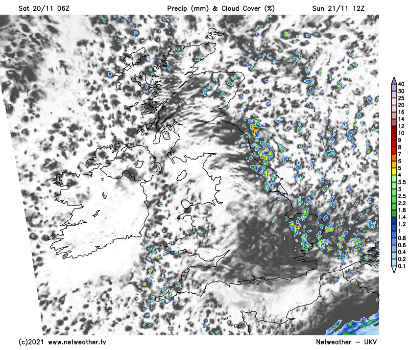
The weather has started mostly cloudy today, apart from some brighter spells mainly over parts of south-east Scotland and north-east England, and we have some rain mainly for central and northern parts of Scotland. This rain belt will continue to move south-eastwards through the country, but fizzling out as it does so, reaching the far north of England by mid-afternoon and the Midlands by late evening, but with very little rain associated it by the time it reaches the Midlands.
Following behind over Scotland will be much clearer, colder weather with some showers spreading from the north, falling mainly as rain or hail at low levels but with snow over higher ground. To the south, it will stay mild, dry and generally cloudy, but with some brighter spells mainly to the east of high ground.
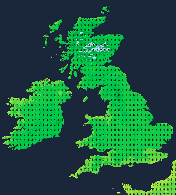
Over much of England and Wales, temperatures will reach 11 to 13C today, which is quite mild for the time of year but not exceptionally so, and not as warm as it has been in many places on the last two days, mainly due to more cloud cover. The south of Scotland and Northern Ireland will also make around 11C, but with the northerlies setting in northern Scotland, it will be colder with highs of about 7 or 8C.
Tonight, lows of 3 to 5C will be typical over much of the country, but there will be a frost in inland parts of Scotland and parts of north-west England, with temperatures dropping close to or just below freezing. Showers will continue to affect the northern half of Scotland and will spread down the eastern side of England, these again falling as rain or hail at low levels, but with snow on high ground, especially in Scotland.
Tomorrow will see the first northerly outbreak affecting the country. But it won't be an especially potent one, with showers falling mainly as rain in eastern Britain, except over high ground where there will be snow in Scotland and also sleet and wet snow in some upland parts of eastern England. Most central and western parts of the UK will have a dry, sunny day.
Temperatures will reach 7 to 9C in most parts of England, Wales and Northern Ireland, but it will be colder in Scotland and parts of north-east England with highs of 5 or 6C typically.
Frost will be more widespread on Sunday night into Monday, with most western areas falling close to freezing, but temperatures will hold up at 2 to 4C in eastern England and near north-facing coasts. Showers will continue to feed into eastern England overnight but will tend to fade towards dawn.
High pressure will return from Monday to Wednesday, with temperatures recovering to about average for the time of year, with highs of between 8 and 10C for most, but still rather lower than we've generally been used to recently. There will still be some frost in places overnight. From Thursday, it looks likely that the northerlies will return, but, at least to begin with, these will probably again not be cold enough for widespread snowfall at low levels. There is more uncertainty towards next weekend, when we could see some colder northerlies with greater potential for lowland snow, especially in the north, as well as strong winds.