A look at the global drivers that may determine whether winter 2021-22 will be mild, average or cold. The Netweather Winter forecast will be issued later this month.
The Netweather Winter Forecast, produced by me this year, will be issued before the end of the month. However, before it’s issued, I thought I’d do a preview looking at the main parts of the jigsaw coming together to make the forecast, namely the main seasonal climatic drivers that can have an influence on the weather patterns throughout the coming winter. This blog will not draw any conclusions on what we may expect this coming winter, you’ll have to wait for the Winter Forecast for that, but it may indicate the likelihood of an average, cold or mild winter.
The winter forecast will firstly look in-depth at the main global climate drivers which can persist in particular phases throughout the season or can be predicted to be in certain phases throughout winter based on previous averaged cycle periods. This can give indications, when used in combination, of a broad idea of how this winter may pan out.
ENSO arises from changes in wind direction and sea surface temperatures in the tropical Pacific which in turn affects the climate of the tropics and sub tropics. When El Niño occurs, the central and eastern tropical Pacific Ocean becomes warmer than average. The opposite happens with La Nina, with the central and eastern tropical Pacific Ocean becoming colder than average.
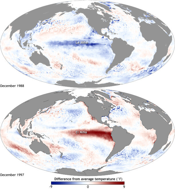
La Nina conditions have developed this autumn and are forecast to continue during the 2021-22 winter. This will be the second winter in a row with La Nina conditions. It is quite common for La Nina to occur in consecutive winters (but not El Nino).
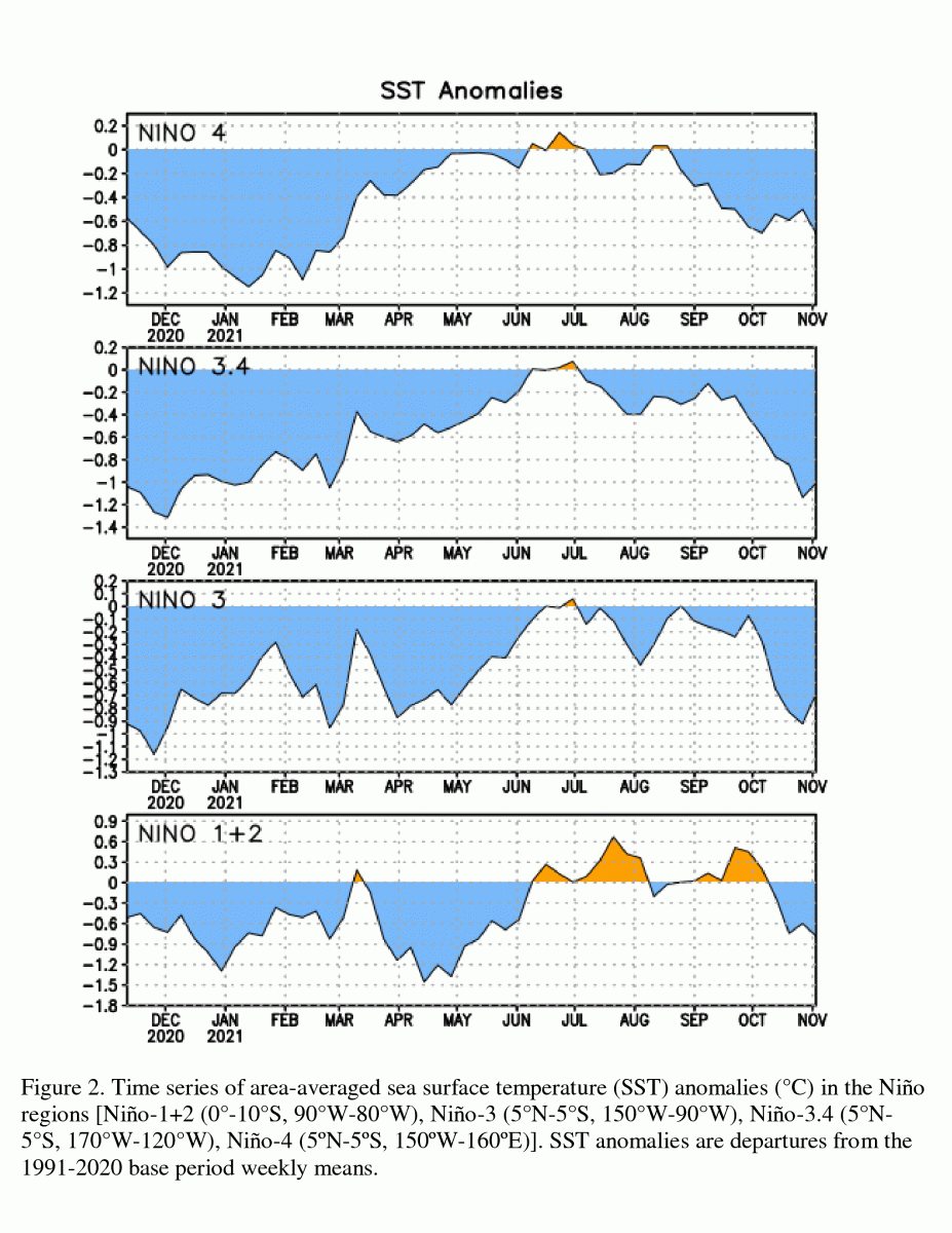
The strength of La Nina can affect the strength and position of the jet stream, troughs and ridges across the northern hemisphere. Typically, a weak La Nina favours a more-wavy jet and thus higher incidence of high latitude blocking in the northern hemisphere during winter, with a greater chance of cold weather for the UK. While a strong La Nina favours a strong and zonal jet stream with a +NAO (North Atlantic Oscillation) that brings mild weather to the UK. However, the position of the La Nina cold SST anomalies in the tropical Pacific can also cause variability in the upper patterns over the northern Pacific and subsequently downstream over North America and the North Atlantic.
Some most recent model forecasts hint that La Nina may become moderate or even strong. This needs watching, because if a strong La Nina does transpire it could be a different outlook for winter then with a weak Nina – as mentioned above. However, the cold 2010-11 winter featured a strong La Nina, so the theory that strong La Nina = mild / +NAO winter doesn't always ring true. This could be to do with the Nina structure, i.e. where the cold anomalies are. In the winter of 2010-11, La Nina was east-Pacific based rather than central as in the case of other strong La Nina winters that have featured little high latitude blocking and were mild overall. There are suggestions that La Nina this winter could be east-based, at least initially, though may become basin-wide. This mirrors winter 2010-11.
The easterly or negative phase of the Quasi Biennial Oscillation (QBO) is associated with more of a poleward shift of the sub-tropical jet leading to an increase in Rossby wave-breaking events over Eurasia. This leads to a weakening and shifting of the polar vortex and a slowing down and weakening of the northern hemisphere polar jet stream, thereby causing a meandering jet stream leading to cold arctic outbreaks over Europe. A westerly QBO, conversely, leads to a stronger polar vortex in the stratosphere.
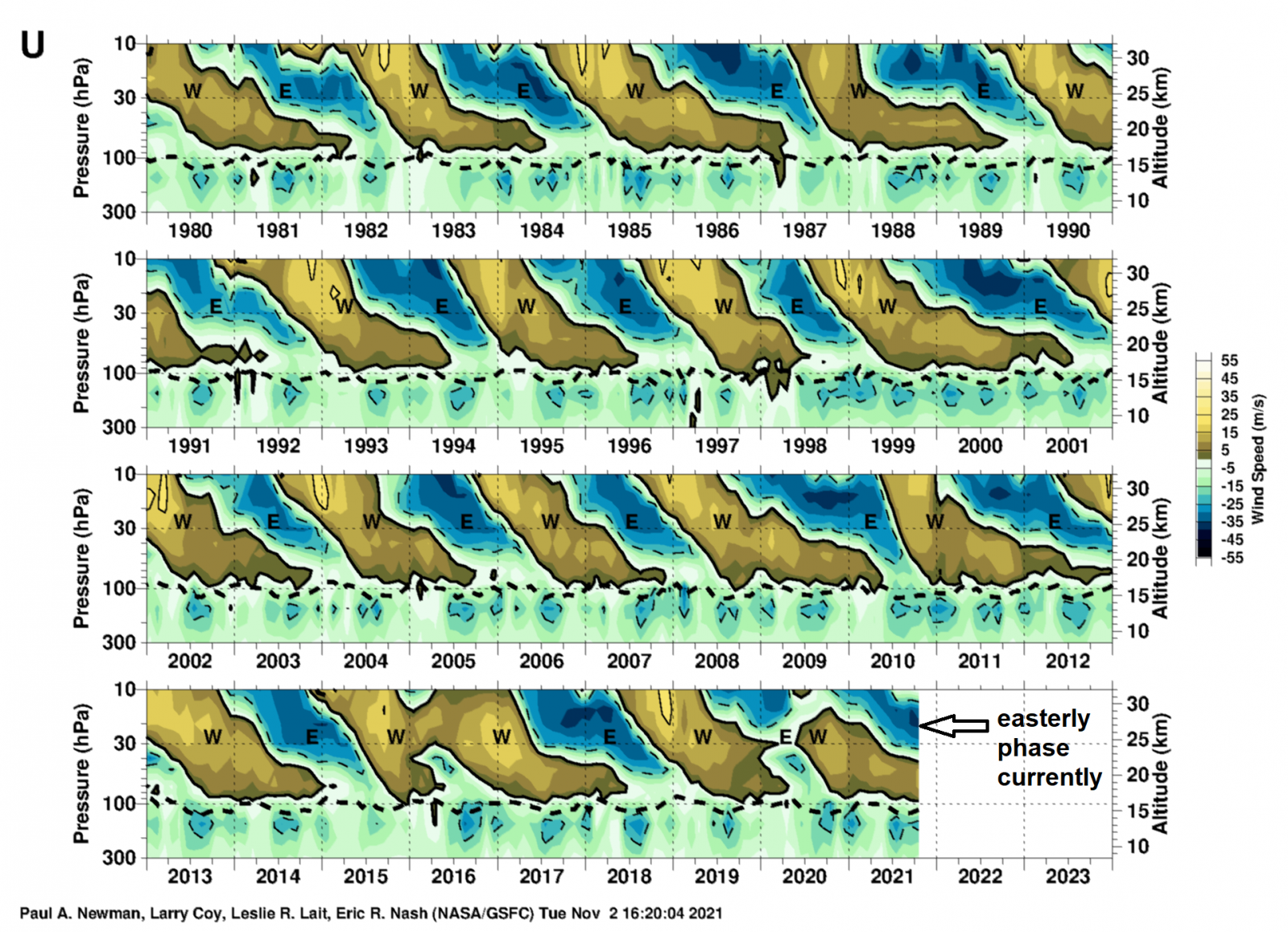
An easterly QBO is expected through the coming winter, so there is a greater probability of a weakened and displaced Polar Vortex occurring this winter which can lead to greater probability of cold outbreaks affecting the UK and other parts of Europe this winter than would be the case with a westerly QBO.
We entered the Solar Minimum in 2017, but as of late last year we entered solar cycle 25 and are now rising out of the solar minimum with sunspot activity increasing.
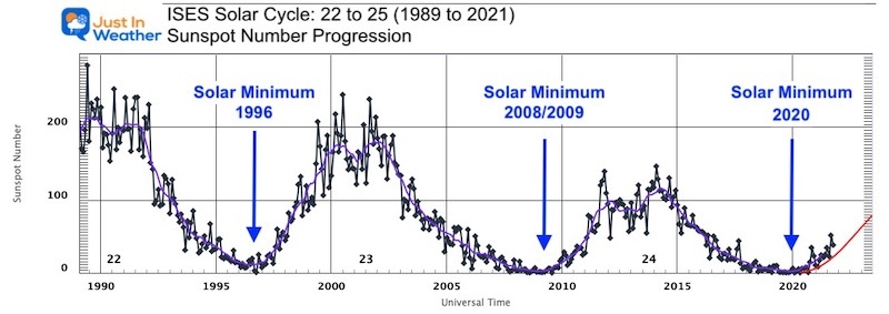
In general, given the lag of the effects of reduced sunspot activity, years in and shortly following a solar minimum tend to have a weaker stratospheric polar vortex and are more prone to blocking, with the opposite true in solar maxima winters. As we are just emerging from a solar minimum and the lag effects of it, the increase solar activity is unlikely to play a major role. The cold winter of 2010-11 featured a lot of high latitude blocking and, like this winter, that winter was emerging from a solar minimum with an increase in activity while was also a La Nina winter, though with a westerly QBO. The winter of 2017-18 also featured some blocking, when we were entering the most recent solar minimum. So, given the history of winters with blocking coinciding with when we are coming out of a solar minimum – this is another tick in the box that points to winter that may feature more increased blocking than average with cold outbreaks.
The Madden-Julian Oscillation (MJO) has a significant impact on northern hemisphere extratropical weather patterns, including North America, Atlantic and Europe, so there are correlations that can be made between the 8 different phases of the MJO and the lagged impacts on the upper air patterns that might be expected over the North Atlantic and Europe based on composites of previous events. The impact of the MJO on European weather is strongest about 10 days after the MJO is in phase 3 or 6, the probability of a strong +NAO is increased about 10 days after the MJO is in phase 3, but decreased 10 days after phase 6, with a probability of a -NAO increasing after MJO toward phases 7-8.
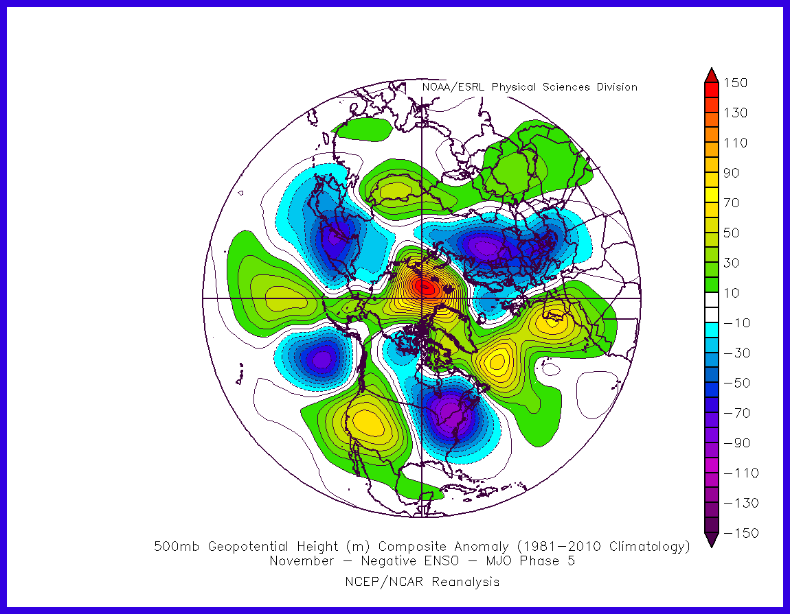
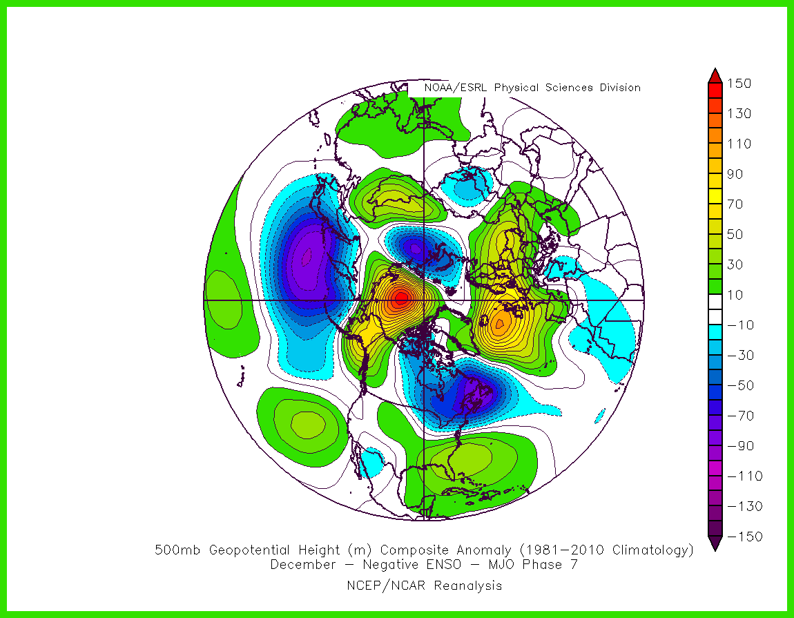
The MJO is currently in phase 5 at low amplitude over the maritime continent, but is weak, as typical in La Nina - which tends to mute the signal. But, with a lag of 10 days, phase 5 can promote blocking to the west of the UK, which may lead to a northerly later in November. If the MJO wave progresses to phase 6-7-8, then this can promote northern blocking and cold episodes for northern Europe.
Currently MJO in phase 5, lag response in La Nina may promote this 500mb pattern later this month
IF the MJO progresses to phase 7, the lag response may promote a pattern like this in early December, with a blocked Atlantic:
As the MJO can only be predicted on a relatively short time scale of a month at best, its impacts on January and February’s weather are impossible to predict at this range.
Way up in the stratosphere, it is normally very cold in winter, but there are times when it "warms up" relatively speaking. Stratospheric warming occurs when atmospheric waves from the troposphere move into the stratosphere. As these waves move upward into the stratosphere they will often push the polar vortex (PV) away from the North Pole. This brings warmer, midlatitude air northward, and cooler, arctic air southward. A downward motion field also causes the poles to warm further.
The zonal mean zonal wind at 10 hPa is forecast to be stronger than usual, so the stratospheric PV will become strong
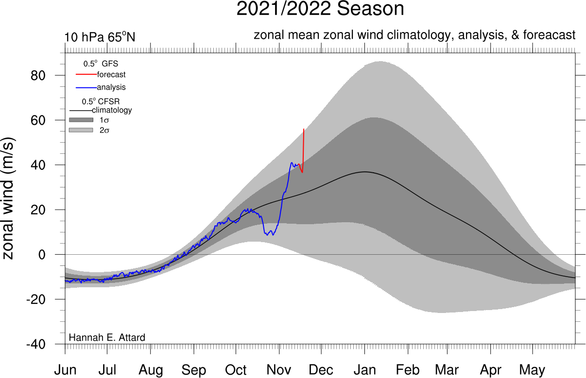
As these waves enter the stratosphere, it can warm the stratosphere and causes the mean flow to decelerate, weakening the Polar Night Jet (causing the PV to weaken or split). With the weakening of the polar night jet, its winds then begin to converge towards the centre and descend, resulting in warming due to compression. This event is known as a Sudden Stratospheric Warming (SSW). A SSW is technically defined to have happened when the mean zonal wind at 60°N and 10hPa (approx. 30km high) reverses to easterly. Once winds shift east, ridging patterns are usually evident in the mid-upper latitudes. Disruption of the tropospheric PV continues, which allows cold air to be displaced from high latitudes and spill south. Stratospheric warming is often associated with cold outbreaks, which generally last for weeks.
Stratospheric warming events have a tendency to occur earlier in the winter if we have a -QBO and low solar activity like this winter. However, there is no imminent signs of a warming showing in the model. In fact, the stratospheric polar vortex is forecast to become stronger than average. Though, fortunately, the stratosphere is not yet well-coupled with the troposphere.
So, we may be looking at mid-December at the earliest if a warming occurs. Then it can take anything between 2 to 6 weeks for the impacts of the SSW to work its way down 30-50km up and impact the stratosphere. Unfortunately, a SSW cannot be forecast well more than a few weeks ahead.
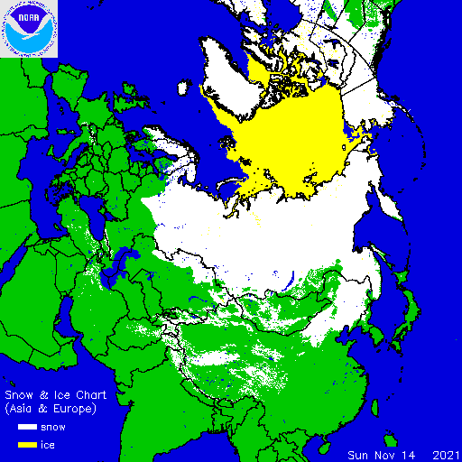
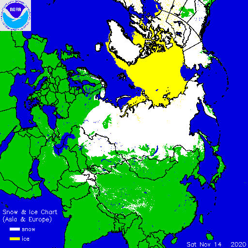
Snow coverage over NE Europe is more extensive than this time last year. In fact, it’s similar to this time in November 2010 – which featured a very cold second half to the month. Arctic sea ice is also more extensive over the Kara Sea and adjacent Arctic sea than this time last year. Generally good snow coverage over Russia and NE Europe. So some positive signs in this respect.
Current snow cover for Eurasia
This time last year
The North Atlantic is currently in a warm Atlantic Multi-decadal Oscillation (AMO) phase since 1995, before 1995 there was a cold phase between 1964-1995.
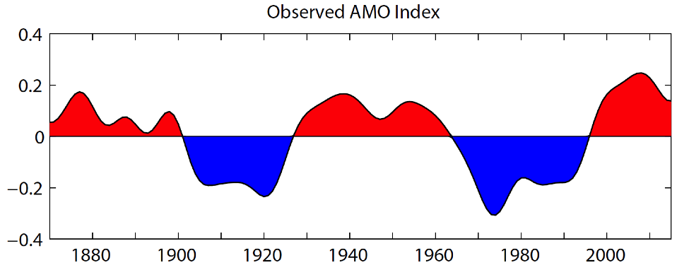
The AMO has significant regional and hemispheric climate impacts, such as modulating summer climate over North America and Europe, Atlantic Hurricane activity, but also, more crucially for winter, northern hemispheric mean surface temperature and Arctic sea ice.
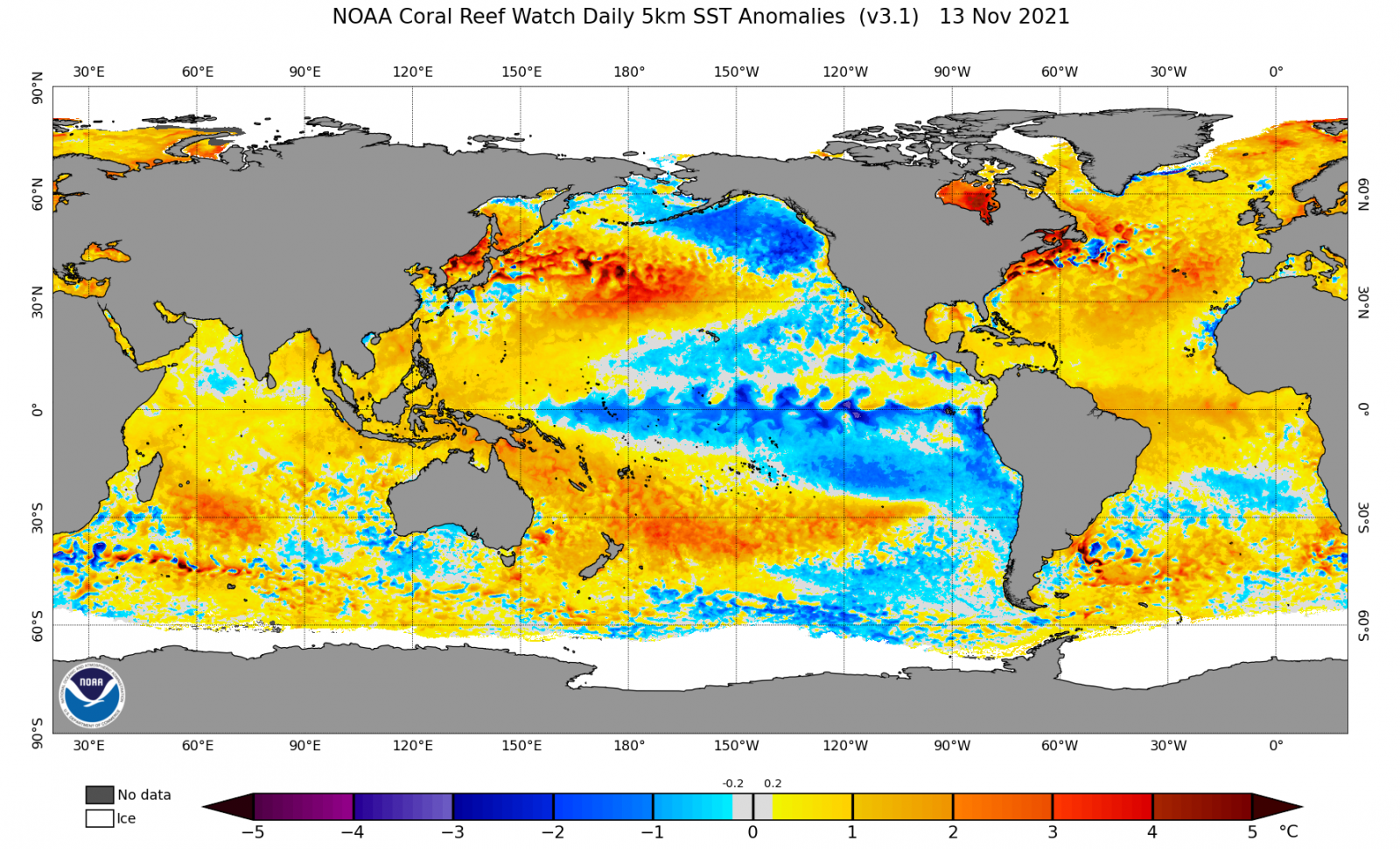
Much of the North Atlantic basin to the west of Europe is anomalously warm, so this may have a moderating effect on any cold polar incursions – particularly in more maritime areas of western Europe, including the UK. The warm SSTs may also be causing below normal arctic sea ice extent directly or indirectly through warming the air moving poleward.
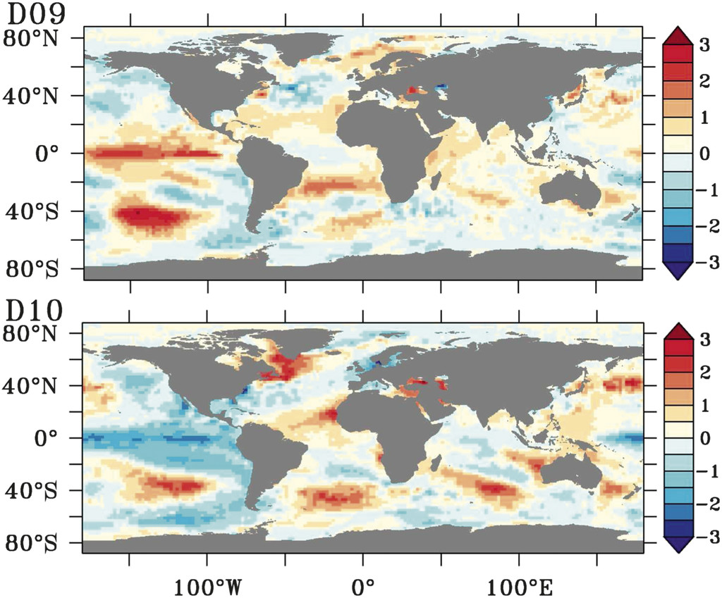
During the cold winters of 2009-10 and 2010-11, the Atlantic SST anomalies presented a tripole pattern, with cold SST anomalies sandwiched between warm anomalies to the north and south. This has been correlated to the polar jet stream shifting south and leading to the periods of -NAO during these winters. At the moment, there are no signs of such a conducive SST pattern.
Colder than normal winters 2009-10 & 2010-11 had a SST tripole pattern, with cold SST anomalies sandwiched by warm anomalies. Below is SST anomalies in December 2009 (D09) & December 2010 (D10):
During positive phase of the Indian Ocean Dipole (IOD)- Westerly winds weaken along the equator allowing warm water to shift towards Africa. This sets up a temperature difference across the tropical Indian Ocean with cooler than normal water in the east and warmer than normal water in the west. During the negative phase, the reverse happens - with warmer than normal water in the east and cooler than normal water in the west.
The persistent and strongly positive IOD in 2019 has been suggested by some papers to have been a key driver in the anomalously positive NAO that was responsible in bringing an exceptionally warm and wet winter in 2019/20 across the UK and northern Europe.
The IOD has recently been weakly negative but is forecast to become neutral through winter, as would be expected as the monsoon shifts south and trade winds change. So, it is likely the IOD will have little impact on this winter’s weather patterns.
This winter will likely feature:
a weak / moderate east-based La Nina
descending eQBO
low solar activity coming out of a Solar Minimum
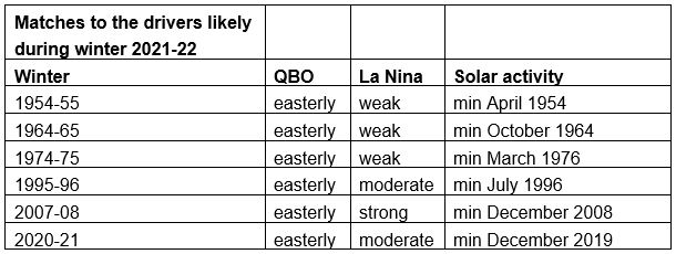
The years in the table below most closely match the 3 main drivers of QBO, La Nina and solar activity:
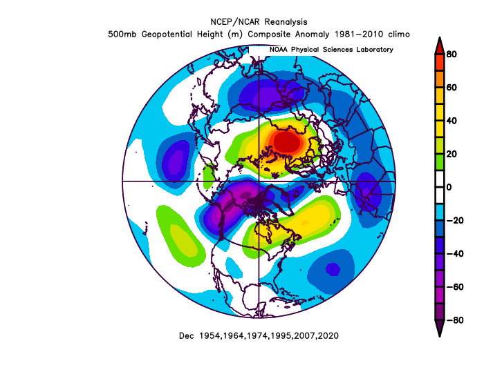
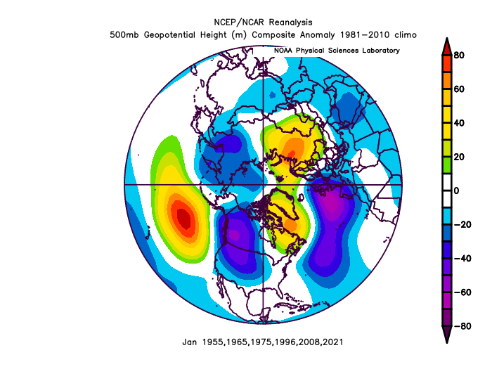
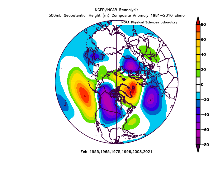
Below are the 500mb height anomaly composites for December, January and February and analog years.
December composite features a meridional pattern with anomalous ridging over central N and NW Atlantic, troughing over NE Atlantic and NW Europe, ridging over W Russia.
January composite features northern blocking with positive heights centred over Labrador and NW Russia, low heights over Azores and western Europe.
February composite features northern blocking centred over Iceland, low heights Azores through into mainland Europe.
Based on the analogs, December features Atlantic ridging but a generally unsettled look for the UK with Atlantic lows moving NW to SE, with potential for some northerly outbreaks. January and February certainly a cold and wintry look in the mean, with northern blocking and low pressure close to the south and southwest of the UK.
If we took out the eQBO match from the analogs, then the infamous cold winter of 2010-11 would be a good match. Although wQBO was present that winter, it was La Nina, albeit a strong one and we were on the early rise out of a solar minimum. There is potential that La Nina may become moderate or even strong based on current forecasts.
Taking in all the above, it generally points to a rosy picture for a colder than average winter, backed up by analogs of past cold winters that are a similar match with regards to climatic drivers. However, the Earth’s surface continues to significantly warm, with recent global temperatures being the hottest in the past 2,000-plus years. The past six years have been the warmest on record since 1880, with 2016, 2019 and 2020 being the top three, according to a World Meteorological Organization (WMO).
This background warming means warmer than average periods are outnumbering colder than average. September, October and, so far, November have seen temperatures above average and with North Atlantic SSTs anomalously warm basin-wide this autumn, it may moderate any cold polar or arctic incursions from the north or northwest early in the winter, while western Europe may take longer to cool down with an anomalously warm source upstream. With all the anomalous warmth building up through the summer and lingering into autumn, cold weather has often been delayed until the New Year in recent years, with December more often than not mild. So, it will take some pretty cold incursions to overcome this, particularly with the warm Atlantic this autumn. Continental arctic airmasses from the east or northeast probably least likely to be affected by the anomalously warm Atlantic.
So, as you can appreciate, it’s not that clear-cut making a long-range forecast for a whole winter. There are so many pieces to the jigsaw (climatic drivers) that need to be considered and looked at individually to how they may behave and affect our winter. Then how they will all work when combined. Analogs can be useful to see what happened with similar combinations of drivers in particular phases, but they have the limitation that no one winter is like another with similar backgrounds.