Summer, averaged across the UK and the 3 months, has been warmer and drier than average but some areas, particularly the highly populated SE, have been wet and not warm. A change for next week.
As 'Meteorological Summer' draws to an end (the 3 months of June, July and August for statistical purposes) attention moves to 'Back to School'. There is a change in the weather on the way this weekend. So if you are back this week, it’s more of the same thanks to the stubborn High pressure. Next week, the Atlantic is in charge.
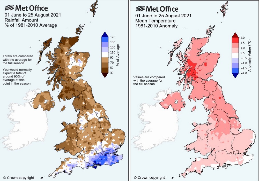 UK summer data until 25th August, showing very wet conditions in SE, dry for most and warmer than average (by day and night) away from the south coast and far east.
Feelings about this summer vary across the UK, as do the start of term dates. Much of the UK has been very dry, to the point of concerns about water scarcity in parts of Scotland and NW England. However, for SE England and parts of southern England including the Isle of Wight, it has been much wetter than average. With this ongoing cool, cloudy flow around a high pressure and the lacklustre Bank Holiday weekend, there will be despondency in some quarters about summer 2021.
However further west it has been drier, sunnier and warmer. Tyndrum in Highland Scotland has claimed the top slot for this August’s temperatures. But it is also the joint lowest August maximum since 2010. It’s not actually been that hot. And the top slot hasn’t been claimed by Scotland in August since 1931. West has been best this summer. It was back in July when Extreme heat warnings appeared for Northern Ireland and SW Britain when temperatures tipped into the low 30sC.
The High pressure centred just north of mainland Scotland continues to feed cool air down through the North Sea. It is picking up moisture, brings outbreaks of light rain and there has been a lot of cloud. It is known as anticyclonic gloom. Under these grey skies, it feels damp and cool, like you might just need the heating on, but that will have to wait. It is still August, put a jumper on kids, or at least some socks. This will be a factor for pupils sitting in classrooms with open windows.
Where the cloud does break up and the sunshine appears it does still feel warm, and you might need sunscreen if out for any length of time. The north to northeast winds pushes in more cloud but further west, to the lee of high ground the air dries out and sunny spells get to work.
Temperatures on the 1st will be around 17 to 21C. Thursday and Friday could see 22 to 24C in the sunnier spots with more sunshine appearing by lunch break on Thursday. Western Scotland still faring well but the schools have been back a while now.
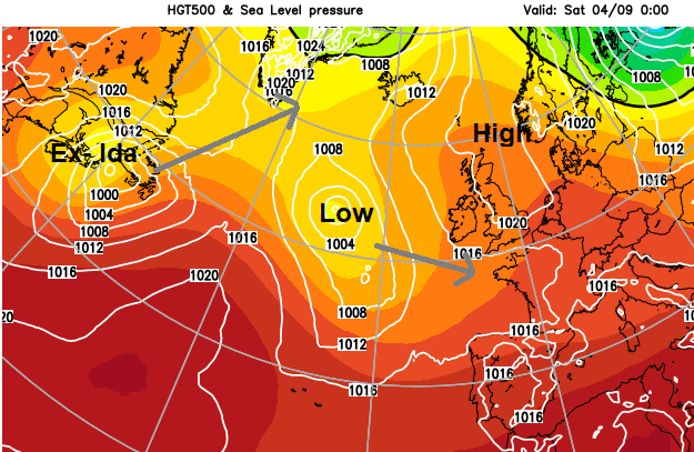
If you are starting back on Monday the 6th there looks to be quite a shift in the weather by Sunday. However, this high pressure steady setup has been around for ages and sometimes a high takes longer to shift. Also, what was Hurricane Ida will have decayed over the United States and be moving offshore from the east coast. That lingering post-tropical energy will add into the forecast mix.
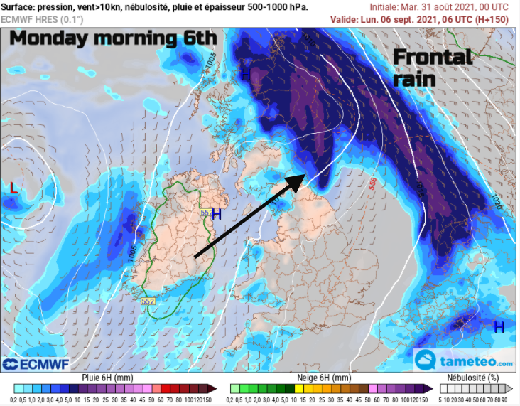
Currently, it looks like the high pressure does give way on Sunday and frontal rain with some heavy even thundery downpours spread up from the SW. Right across the UK and should be clearing NE Scotland early on Monday morning. However, those timings could change.
Temperatures continue along the high teens/low twenties lines and next week looks more showery from the west. So, the kind of weather that keeps everyone on their toes and needs a raincoat and sunscreen. Fine and bright, warm in the sunshine but still the risk of a downpour.