High pressure in control until the end of the coming week means the fine, sunny and very warm or hot conditions will continue for most until later on Friday, though there will be some isolated thundery showers developing most days.
Saturday was the warmest day of the year so far, with Ballywatticock in Northern Ireland seeing the highest temperature in the UK, reaching 31.2C. This is also the highest temperature ever recorded in N. Ireland since records began. All four nations of the UK recorded their warmest day of the year so far too. Sunday’s set to be another hot day in the south, but northern areas will be cooler and cloudier than yesterday.
The generally fine and settled weather looks to continue through much of the coming week, as high pressure remains sat over or near the UK. There will be very warm or hot sunshine across England and Wales, warm and sunny for Scotland and N. Ireland. Warm nights will be a feature this coming week too, so could be some uncomfortable nights sleeping for some.
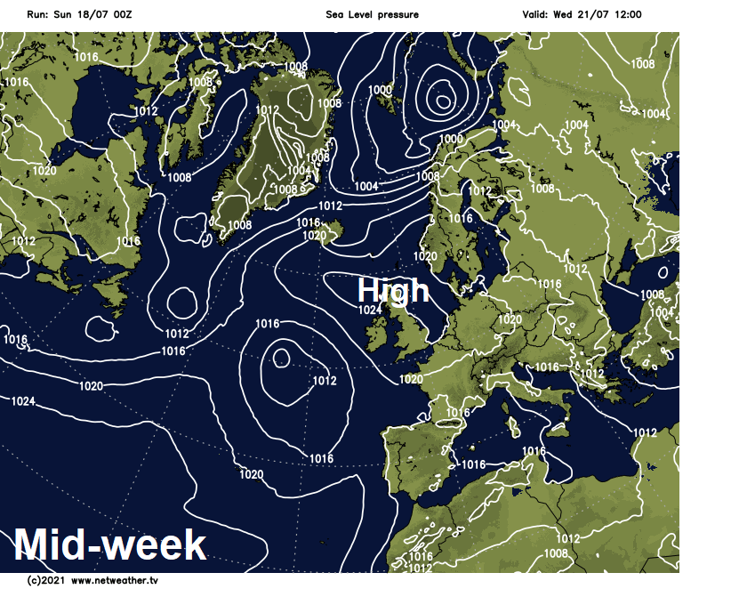
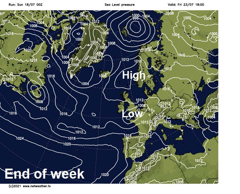
There will be isolated heavy showers or even thunderstorms breaking out in the afternoons, but most places will miss them. Signs that later in the week low pressure lurking out in the Atlantic will push in from the southwest by Friday, as high pressure retreats, bringing a threat of thundery downpours across southern areas. This heralding a general nationwide transition to more unsettled conditions next weekend, as low pressure takes hold.
For now, a glorious start to Sunday across England and Wales, with blue skies for many. It’s been a warm night, uncomfortable for some, with temperatures at 7am already 19-20C across eastern England, even 21C in Aberdaron in NW Wales. Mostly blue skies will continue across much of England and Wales through today, so becoming very warm or hot, temperatures reaching 22-25C across northern England and north Wales, 26-29C across south Wales, central, southern and eastern England, 30-31C inland across SE England. However, the heat may tigger a few isolated heavy showers across central and eastern England this afternoon
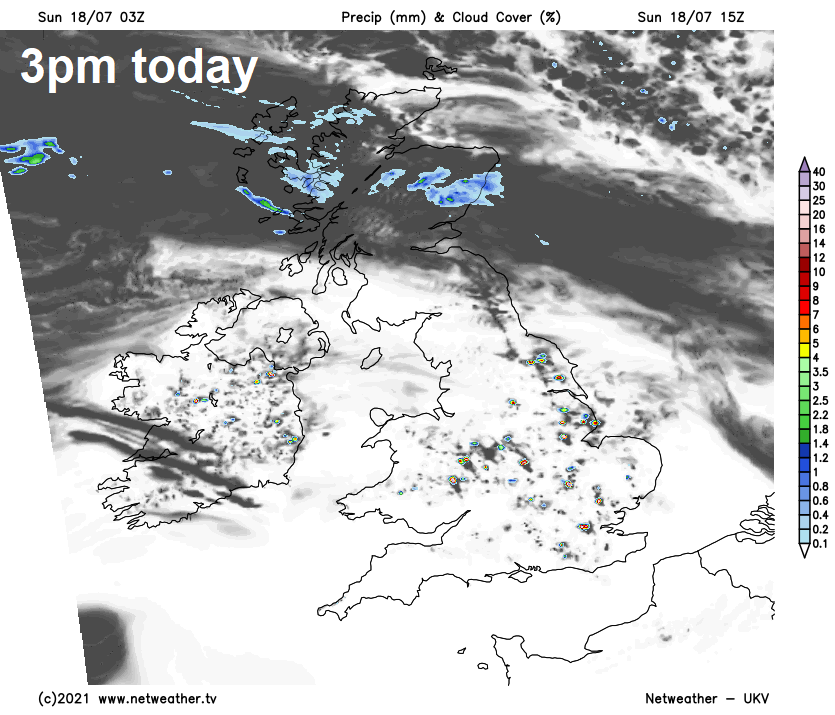
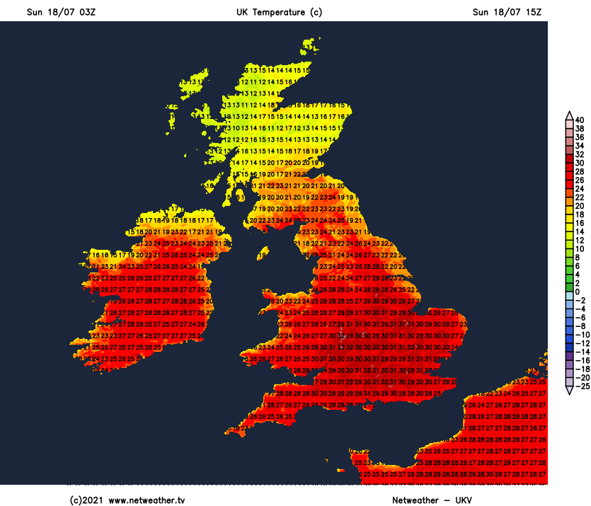
A cloudier and cooler story today across N. Ireland and Scotland from the central belt northwards, thanks to a weak cold front draped across the far north, with some patchy rain or drizzle passing through across northern Scotland. Some sunshine across southern Scotland and later coastal eastern Scotland. Temperatures here lower than yesterday, particularly for N. Ireland which had a hot day yesterday, reaching 16-21C.
After a warm night for many, Monday promises to be another mostly dry, very warm or hot day for many, with lengthy spells of sunshine. Some low cloud in the northeast at first before breaking up to allow sunshine here too. Highest temperatures will be across central, southern and western areas – reaching 25-29C. Cooler across northern Scotland, which will be cloudier and along North Sea coasts with onshore breeze, temperatures here pegged back to 19-21C. However, the heat will trigger some isolated heavy thundery showers across central and southern England. But you’ll be unlucky to catch one.
A very similar day on Tuesday, with high pressure going nowhere fast, allowing much of the UK to see plenty of sunshine, though more in the way of cloud to start across Scotland, which may bring the odd spot of rain or drizzle, before cloud breaks later to sunny spells. Very warm or locally hot for England and Wales, temperatures reaching 24-28C, this heat will again trigger some isolated slow-moving heavy showers or thunderstorms across eastern England. Scotland and N. Ireland not so hot, but still reaching 21-24C inland.
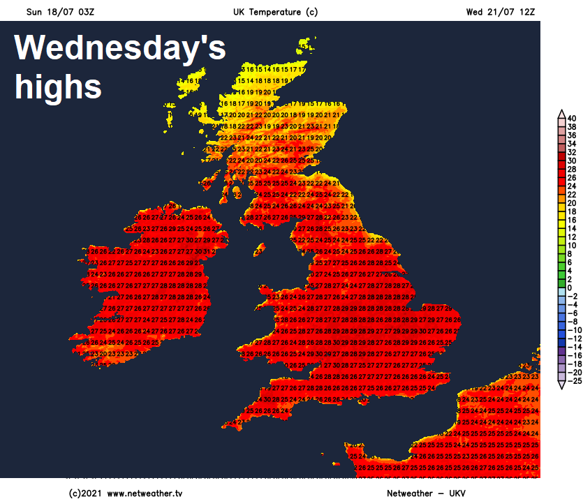
High pressure still in control on Wednesday, bringing another fine day with plenty of sunshine for most, top temperature perhaps 26C inland across Scotland, 26-29C across England and Wales, cooler around coasts. Again, a risk of the odd rogue heavy shower or thunderstorm towards the east of England. Still very warm, sunny and mostly dry for many on Thursday, though a few isolated showers are possible again in the east and the west may see an increase in cloud through the afternoon.
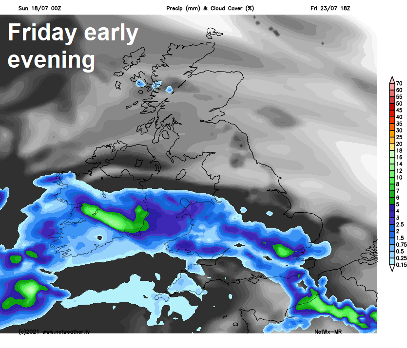
High pressure that’s sat over or near the UK and has kept and will keep our weather mostly fine, dry and very warm for over 7 days looks likely to retreat towards Scandinavia by the end of the week. This will allow an area of low pressure out in the Atlantic to make inroads from the southwest on Friday. So after perhaps a fine, sunny and dry start, cloud will increase from the southwest across southern areas, with thundery showers moving northeast through the afternoon and evening. Northern areas perhaps staying mostly dry, though risk of showers in the northwest. Unsettled conditions gradually taking hold across most parts next weekend, as low pressure moves in across the UK, with slow-moving heavy and thundery downpours developing to affect many areas during the day.