


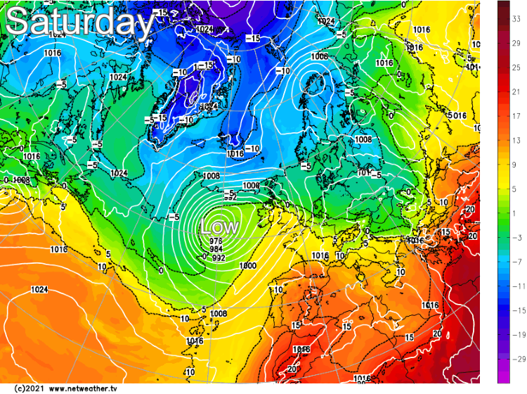
It's a wet start to the weekend, thanks to low pressure out to the west of Ireland. That same low will stay nearby for several days, keeping the weather unsettled, but it will also be milder with 20c likely for some on Sunday.
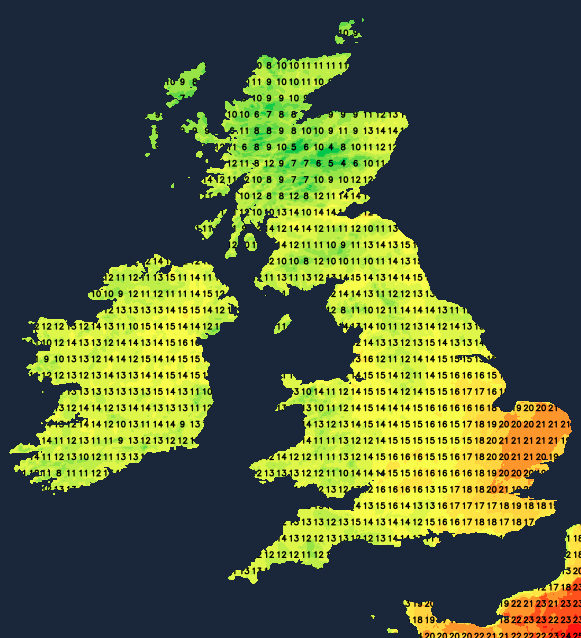
As starts to May weekends go, this one is unlikely to go down in history as a memorable one, but there is a silver lining with all the cloud and rain: Warmer air. It's spreading up from the southwest as we speak, and temperatures will make it up into the low twenties in the southeast and East Anglia tomorrow.
If you're hoping the return of warmer temperatures is going to signal the start of some summery weather, unfortunately, that's not the case. As the same low pressure will stay in charge of our weather into next week - there will be some sunshine, but also showers, one or two longer spells of rain, and even some thunderstorms to look out for.
Today, low pressure is out in the Atlantic to the west of Ireland, throwing its weather fronts northeast over the British Isles. They arrived overnight, bringing some heavy outbreaks of rain with them, and that'll continue to push its way northeast through the rest of the day on Saturday. Once the main band has passed through this morning, parts of southern and central England will dry up with some sunny spells possible - especially in the southeast. And it'll be in the southeast where it'll be mildest with temperatures potentially rising into the mid or even high teens. The rain will take longer to clear through Northern England and take until later in the day to get into Northern Scotland before it finally clears away to the northeast this evening and overnight.
Behind the main initial band of rain, there's another front, which will bring further spells of rain and showers into Wales, western and central England this afternoon, which will last through the evening and into the night. A few showers are also likely to break out elsewhere, particularly in the northwest, but many parts will be dry. It'll be a mild night too, with temperatures staying in the low-teens for parts of England. They'll still drop away in Scotland, though, with a touch of ground frost possible in some parts of the Highlands.
Tomorrow (Sunday) will see a weak weather front straddling the country, running up from southwest or central southern England, through the Midlands and Northern England. The air will be relatively fresh with sunny spells and some sharp downpours developing to the north and west of it. Underneath it, there'll be a lot of cloud with some patchy bits and pieces of rain. To the southeast of it, there'll be broken cloud, some decent spells of sunshine, and it's here where temperatures will rise to 20-22c. The pay-off for the warmth will be the risk of some heavy showers and thunderstorms later in the day and into the evening. Elsewhere on Sunday, temperatures will generally reach 13-17c.
Looking into next week, the low pressure, which is a few hundred miles west of Ireland today, will have moved east and will spend the first few days of the week drifting about either very close to or over Ireland. That keeps us in a milder flow, but it also means the weather will stay in an unsettled, unstable pattern.
Monday through to Wednesday will all be quite similar days, with sunny spells but also some heavy showers, some of which could be thundery. There may also be some longer spells of rain at times. Temperature-wise, we'll not be too far from average for the time of year; maxes will reach 13-18c typically, with the highest end of that scale likely to be reserved for the southeast quarter of England.
For a bit more detail on all of this, watch Michael Fish's latest weekly forecast:


