Some good news for gardeners and farmers alike, it looks like most will see the back of the frosts that have been a feature of many nights since late March from this weekend. While it stays unsettled with further rain or showers.
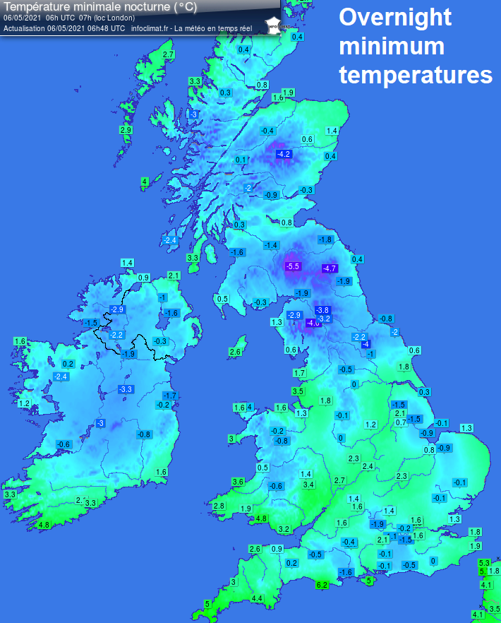
A northerly or northwesterly flow has dominated this week, pulling in cold air from the arctic, bringing chilly days, with maximum temperatures below average, and cold, frosty nights. The sun is quite strong now, though, being only a month-and-a-half away from the summer solstice, so with shelter from the chilly breeze, the sun’s rays feel warm. But the nights have been cold, and where skies clear, there continues to be frost. Eskdalemuir in southern Scotland was the coldest spot last night and fell to -5.5C, even in the south, Benson in Oxfordshire fell to -1.9C and Charlwood in Surrey -1.5C. Enough to damage any frost-sensitive tender plants.
The sun’s warmth is heating the ground at this time of year, and a shallow layer of air above it beneath cold air aloft deep through much of the troposphere, where our weather happens. This creates instability when pressure is low enough, as has been the case this week, which has allowed those all-familiar cauliflower-like towering cumulus to bubble up, eventually into cumulonimbus clouds – where thermals are strong enough. These cumulonimbus clouds producing hail, thunder and lightning have been seen across parts of the UK over the last few days, with some quite dramatic skies, with pale hail shafts against dark cloud bases.
Today will see further sharp showers developing and spreading southeast across the UK, and it will be unseasonably cold. Scotland and parts of northern England have seen snow falling and settling over higher parts overnight from showers, the snow level rising to the highest elevations through the day. Temperatures may struggle to rise out of single figures, even in parts of the south.
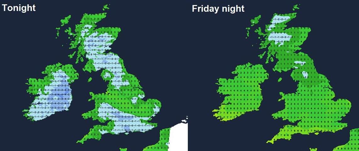
Then tonight, showers will generally fade, and skies will clear to allow temperatures to fall into low single figures or close to freezing, allowing a ground frost locally or patchy air frost in the north. Another patchy frost possible Friday night too in the north, particularly earlier in the night. But tonight looks like the last night of frost risk for a while across the south, with Friday night seeing a strengthening southeasterly wind develop across the south, bringing in milder air.
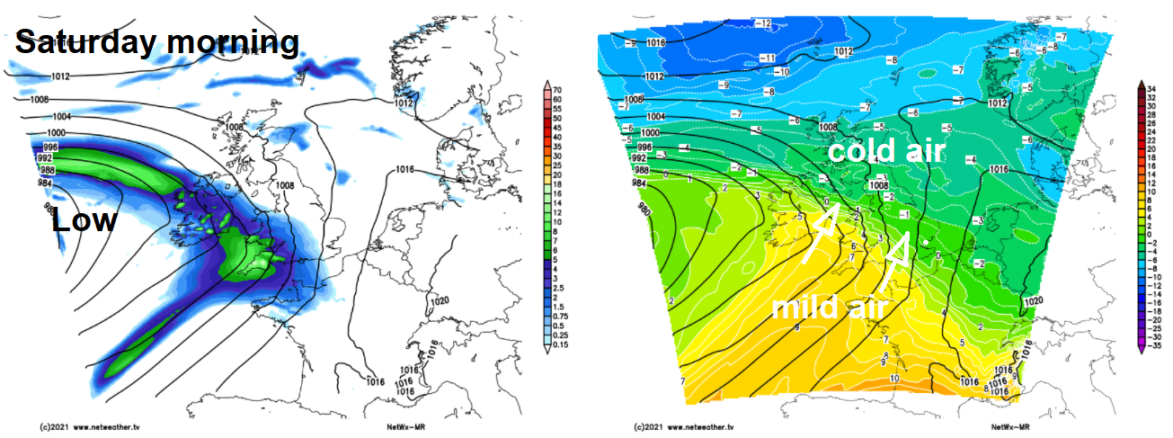
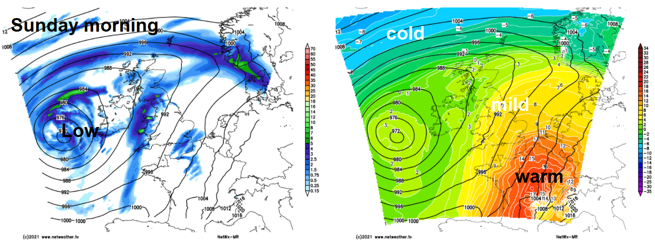
A deep but slowly filling area of low pressure will move in just to the west of Ireland over the weekend. Not only will this low bring wet and windy weather to all parts on Saturday and blustery showers on Sunday, it will also bring southerly veering southwesterly winds dragging in warmer tropical maritime air from quite a way to the southwest of Iberia. So days and nights will become warmer. We could see 19-20C on Sunday in the southeast, if the sun comes out. Daytime temperatures then look to reach the mid-teens most days next week in the south, low teens in the north, with the majority of the UK looking to see frost-free nights too.
So finally, gardeners, like me, will be relieved to finally put out and plant tender frost-sensitive plants that we’ve had to keep inside since late March, following the frostiest April on record.
And another bit of good news for farmers and gardeners alike, it looks like with the warmer temperatures, it will remain unsettled, thanks to the jet stream remaining active and aimed at NW Europe, with spells of rain or showers likely for most areas through next week after a drenching for many on Saturday. So, this will help to slowly alleviate the very dry conditions that have developed over the past month.
However, we may not be completely out of the woods yet. ‘Ne’er cast a clout until May be out’ – so the old saying goes. A clout is an old word for clothing, so the saying suggests not to put away the warm clothes until May is out. Although the jet stream will be nearby, bringing in Atlantic systems with the rain or showers, there are hints of the jet stream becoming wavy or meridional at times, and if parts of the UK move into the colder side of the waves and into colder polar air, there is always the risk of a frost where skies clear. This risk most likely to be confined to the north, though.