High pressure mostly in charge in the coming week, continuing the dry April theme. Warm early in the week, though a little rain in the north and the odd light shower elsewhere. Turning cooler from mid-week but staying dry. Still an overnight frost risk.
High pressure will generally remain in control in the week ahead, which means very little or no rain for most, continuing the very dry theme this April. It will turn increasingly warmer by day as we head into early next week, some spots in England and Wales reaching 16-17C. However, high pressure will re-position to allow cooler polar air to sweep south from mid-week, heralding a cooler second half to the week. There will be some rain for Scotland and N. Ireland today, the far northwest Monday and generally northern areas on Tuesday. But further south, bar the odd light shower, many will stay mostly dry and sunny most days in the coming week, with high pressure in charge, but with a risk of overnight frost where skies clear.
For now, a cold and frosty start earlier across much of England and Wales, thanks to little or no cloud overnight allowing temperatures to fall to around or a couple of degrees below freezing. Temperatures quickly lifting in the strong spring sunshine this morning, blue skies across SE England and East Anglia for much of the day, patchy cloud building in from the west across Wales, northern and western areas of England.
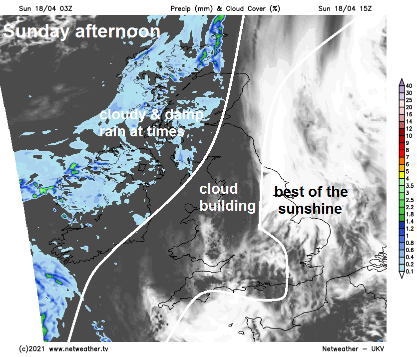
A different story for Scotland and N. Ireland today, where there’s thicker cloud and outbreaks of rain spreading slowly east this morning, though the far east of Scotland could stay dry and bright. The rain tending to fizzle out across most of Scotland through the afternoon but remaining generally cloudy, brighter towards the east, though perhaps remaining damp with further patchy rain for far western Scotland and N. Ireland.
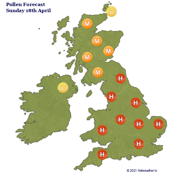
Feeling pleasantly warm in the sunshine this afternoon, best of which will be across eastern areas of England – temperatures across England and Wales will reach 12-15C this afternoon. Across Scotland and N. Ireland a cooler 10-12C. Pollen levels, mostly from trees at the moment, will be high across England and Wales, medium to low across Scotland and N. Ireland.
Much of Scotland and N. Ireland hanging on to cloudier skies tonight, with some patchy rain across NW Scotland, so staying generally frost free. Clearer skies across England and Wales will lead to another cold night and a patchy frost. Though low cloud and fog may move into eastern England overnight.
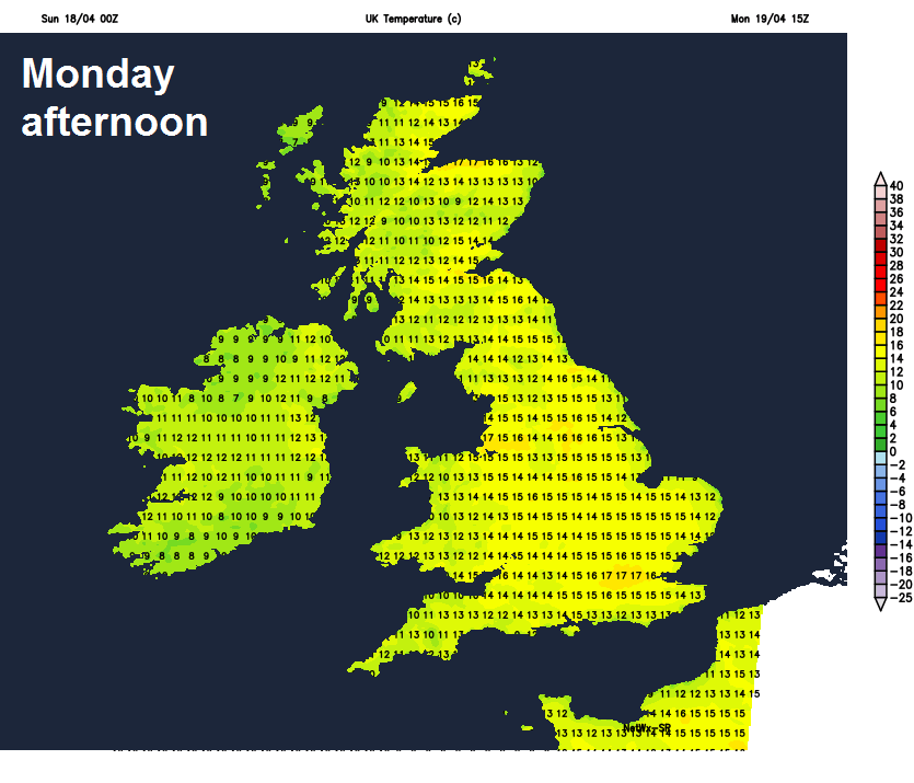
Any early low cloud and sea fog across eastern England will disappear first thing, then another fine day for much of England, Wales and eastern Scotland, with plenty of sunshine, blue skies for some. Though some patchy cloud will build in places. Western Scotland and N. Ireland will be cloudier with some outbreaks of rain. Feeling warm in the sunshine, temperatures perhaps reaching 16-17C across NW England, the Midlands and the London area, 13-15C elsewhere across England and Wales. 12-14C for Scotland and N. Ireland.
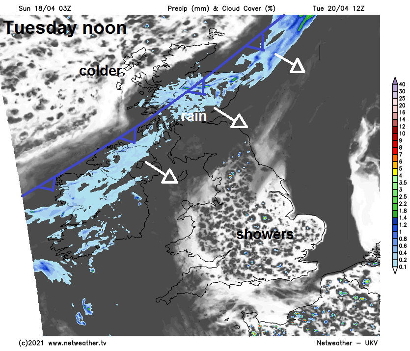
Weather fronts lurking close to the northwest the next few days will try and push in across the UK on Tuesday, but will be squeezed slowly dry by high pressure building in from the west and east. There will be a band of rain along a cold front sliding southeast across Scotland and N. Ireland through the morning, but weakening and turning more patchy as it reaches northern England in the afternoon. Cloudier skies spreading south further south after a bright and frosty start, with a few showers breaking out in places, but some bright or sunny spells too. Turning cooler across Scotland as the cold front clears south, temperatures reaching 9-12C in the afternoon, a warmer 13-16C across England and Wales.
A weak cold front will continue to clear southern areas on Wednesday, but bringing a cloudier day with odd spot of rain or drizzle. Colder but sunnier and drier conditions spreading south across northern areas to the east of high pressure building to the west.
Turning cooler from the north from mid-week, but staying dry with high pressure in control
After a warm start to the week, looking dry but cooler for all for the rest of the week, with high pressure centred over northern Britain. Days likely to be sunny with variable amounts of cloud, warm in the sun but cool in the shade, nights likely to see the return of frosts though.