A fair Easter Sunday before much colder Arctic air plunges down from the north tonight. A change to significant wind chill, hard frost and even snow. You'll need your big coat.
A dramatic cold plunge of Arctic air is on the way to the UK. Starting later today, Easter Sunday and last through Monday into Tuesday. For many, this will bring a hard frost and in the bitter wind, perhaps a realisation that shorts this early in April were a naïve choice. The icy north wind will bring snow, for those who have enjoyed blue skies and warm sunshine it might seem unbelievable. It’s not, find your thermals.
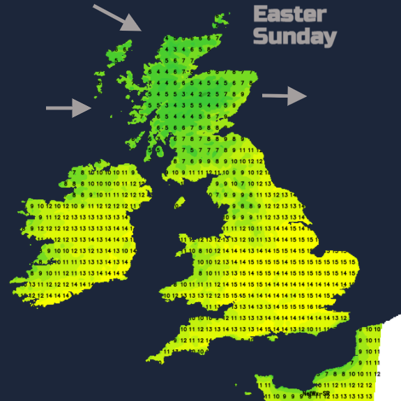
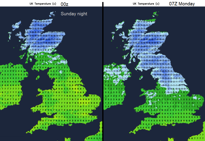
Last week we saw temperatures into the 20s Celsius with 24.5C in London. Scotland managed 15 to 17C more widely yesterday but will drop to barely 3 or 4C by Monday. The Easter weekend so far has been fair and dry with light winds, a nip in the air with but contrasting skies. Glorious blue skies and sunshine for the north and west of the UK on Saturday but lingering low cloud bringing a cooler feel (only 12C max. for southern England) for much of England draw in off the North Sea by a high pressure out west.
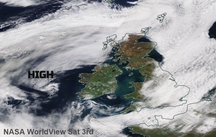
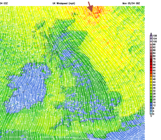
That high pressure is given an almighty elbow out of the way as this bitter northerly flow takes hold. Low pressures way up in the Arctic circle north of Scandinavia will throw cold fronts towards Scotland and as the high pressure is shoved over the northern Atlantic that helps funnel and steady the wintry flow down through the UK.
Easter Sunday
There is a cold, frosty start inland. Low cloud is still lingering over SE England including for London, but this will thin and break. There are pockets of low cloud and murk for western Britain, west of the Pennines, around the Solway Firth and west coast of Scotland which could be more stubborn for the coasts. Elsewhere it is fine and sunny with mostly light winds although a strong westerly has picked up for northern Scotland. So warmer in the sunshine for England today but still only up into the mid-teens.
Still worth thinking about sunscreen if you are out for any length of time or preparing the garden for this cold. For most of today, this change in the weather won’t affect much of the UK. Monday and Tuesday will be much colder.
The far north of Scotland has a Wind & Snow warning from the UK Met Office for Sunday afternoon and all of Monday which mentions “Frequent snow and hail showers”. There will be wild, wintry conditions, the Inshore Waters forecast mentions Severe gale 9, perhaps storm 10 later, high seas, squally snow showers and very poor visibility.
The cold fronts pass over Shetland at lunchtime, bringing rain at first and then snow with a sharp veer to northerly winds. The bands then move south through Scotland this afternoon reaching Northern Ireland and the far north of Scotland this evening.
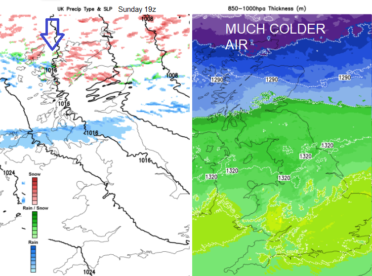
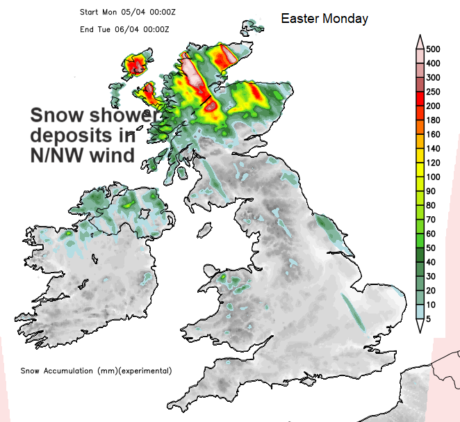
“Frequent heavy snow showers will affect northern Scotland on Sunday night and Monday and may lead to some travel disruption. “Met Office snow warning for northern mainland Scotland this evening and Easter Monday which includes Aberdeen and Inverness. There will be lying snow and blizzard conditions for exposed parts in the bitter wind. A few cms at low levels and up to “15cm possible on highest ground above 300m.”
There will be a hard frost and the wind chill will be blunt. The frontal bands will be over southern Britain by Monday morning, the first bringing patchy rain which will soon clear the south coast of England but the second over Wales to Norfolk early on, will include sleet and even a bit of snow. The wintry showers look to work their way south over East Anglia, maybe a passing flurry for London and Kent as it clears in the morning.
This then leaves the ongoing setup of North to NW strong cold winds with a feed of snow showers. Areas exposed to that flow are at risk of snow and hail showers passing by. There will be gaps in between so you might see darkening skies and falling precipitation in the distance or you get a squally burst, and it moves on. The radar will show the speckled pattern of the moving showers with Northern Ireland perhaps down to Anglesey, Snowdonia and Pembrokeshire looking prone. Northern Scotland seeing most of the snowfall, particularly over the mountains. For other parts, it will depend on how far the showers reach blown further south or SE on that Arctic wind. Many areas stay sunny, dry but very cold. The showers could clip east coast Britain, but the focus remains on northern Scotland and we’ll see how snow showers manage to progress from there.
Temperatures might register as 6 or 7C but it will feel much lower in the wind particularly the gales for Northern Isles and NE Scotland early Monday.
Cold Monday night, very cold everywhere Tuesday night with frost and ice after showers. Gardeners take note but the winds will be easing, and the risk of snow showers fades. Less cold later Wednesday and on Thursday.