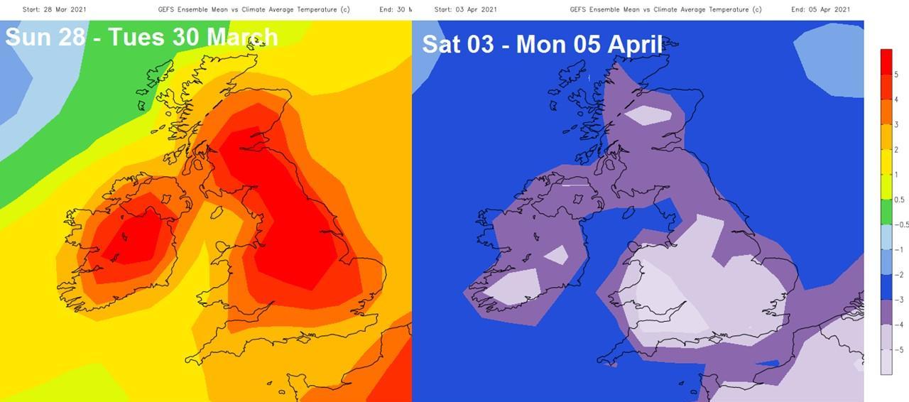
Some newspapers are proclaiming a 'Saharan mini-heatwave' early next week, indeed it will warm up in the south, 23C possible on Tuesday, but a cold shock in store a few days later for the Easter Weekend.
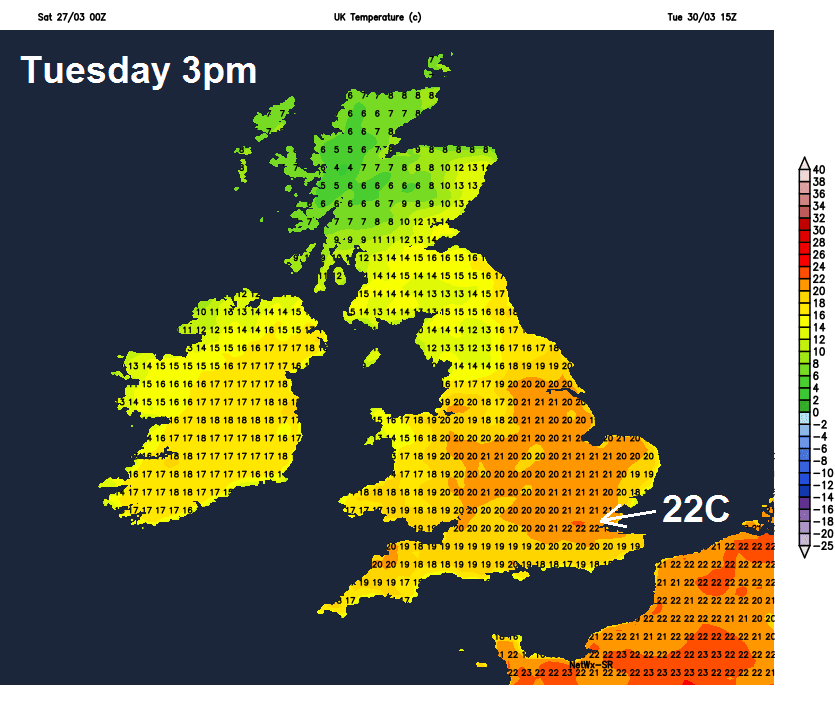
The weather will be on a roller coaster ride in the run up to the Easter Weekend. Some newspapers have headlines this morning of a ‘Saharan mini-heatwave’ on the way early next week and, indeed, it does look like it will warm up through Monday and Tuesday away from the northwest – with temperatures rising into the high teens or low twenties Celsius. The highest temperatures look to be across eastern England, peaking on Tuesday, reaching 21-23C.
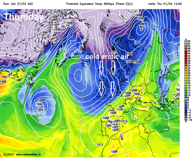
However, a big change to much colder conditions looks on the cards towards the end of next week, with warm southerly winds earlier in the week replaced by northerly winds flooding cold arctic air south across all parts by Good Friday, with cold conditions and even some wintry showers in the north and east lasting through the Easter Weekend.
We’ve already seen a swing in temperatures over the last 24 hours. A brief cold snap arrived yesterday, bringing in wintry showers across the north, with some waking up to snow on the ground this morning in the north. After a chilly start this morning, with temperatures falling to freezing in the north overnight, the cold will ease today. The cold air that arrived from Greenland yesterday will be replaced by a milder southwesterly flow through the day, with temperatures returning back to average.
The southwesterly flow will persist through the weekend and into the start of next week, dragging in a river of increasingly moist sub-tropical air from way to the southwest over the Atlantic. This moist air combined with lift along a slow-moving waving frontal boundary straddling Scotland and N. Ireland will bring heavy rain accompanied by strong winds here from later today through Sunday and Monday. Western Scotland will see the largest rainfall totals, particularly from Sunday through into Tuesday, the Met Office have a yellow warning for rain in force from 1800 Sunday through to 1800 on Tuesday. Today will be the driest and sunniest day of the weekend, thicker cloud and rain arriving in the west later before wet and windy weather sets in across the north for the rest of the weekend. It will stay mostly dry but cloudy across the south on Sunday. Becoming increasingly mild everywhere though.
PWAT (Precipitable Water) chart for N Atlantic next few days shows river of sub-tropical moisture heading towards Scotland
Credit: Wxcharts.com
Cloud and rain persisting across Scotland on Monday, but across much of England and Wales it will become increasingly sunny, as high pressure builds from the south, warm in the sunshine, temperatures reaching high teens, maybe 20C across eastern England. Warmer still across England and Wales on Tuesday, with long spells of sunshine and southerly winds allowing temperatures to lift into the low twenties across east Wales, central, southern and eastern England. Perhaps reaching 23-24C in a few favoured spots. The highest March temperature ever recorded in the UK was 25.6C in Cambridgeshire on 29 March 1968.
Summer to winter next week: Very warm Tuesday then cold on Good Friday
 Cloud and rain still across Scotland Tuesday, this band of rain then looks like sinking south across England and Wales as a cold front during Wednesday, with winds turning north or northwesterly following the front clearing the south later in the day.
This switch to a colder wind direction coincides with a large area of high pressure building to the west and northwest over the Atlantic from mid-week, allowing a dramatic switch to colder air flooding south by Good Friday, after the warm start to the week. Maximum temperatures on Good Friday are forecast by the GFS model to stay in single figures across all parts. The cold conditions are then forecast by models to persist right through the Easter Weekend, with the wind from the north or northeast. Temperatures perhaps failing to reach double figures anywhere throughout, with a risk of widespread frost overnight. There is a possibility of wintry showers too, with snow, particularly over higher ground in the north, but even lower elevations could see snow falling.
The warmer weather next week will coincide with some easing in the lockdown for England as the 'Stay at Home' rule ends here. People will be allowed to meet outside - including in private gardens - in groups of up to six, or as two households (with social distancing). Outdoor sport facilities will reopen, including golf courses, tennis and basketball courts, and outdoor swimming areas. Formally organised outdoor sports can restart. Wales has already seen some changes with travel restrictions lifted, residents can travel wherever they like within in Wales but not to England. Similar rules as England for meeting others outdoors. But Northern Ireland and Scotland remain with the 'Stay at Home' message until later next week. However, for England and Wales, make the most of the warm weather early next week, as the cold arriving over the Easter Weekend will force many to wrap up well if meeting outdoors!