Turning briefly colder with wintry showers today behind cold front bringing band of squally rain east. Less cold over the weekend, turning wet and windy in the north but southern areas mostly dry & mild. Could reach 21C on Tuesday in the southeast.
It is not unusual to see big swings in temperature at this time of year and over the next few days we will certainly experience this, with a marked drop in temperatures across all parts by the end of the afternoon, perhaps as much as 5 to 6C, as cold front clears east introducing cold polar air from Greenland. With the colder air, showers moving in from the west will turn increasingly wintry, falling as snow even to lower levels in the north and west after dark. After a cold and frosty start to Saturday, a mild southwesterly flow will return, with wet and windy conditions for northern and western areas for the rest of the weekend and into early next week. However, much of southern and eastern England will likely stay dry, while it looks to turn increasingly warm too early next week, perhaps reaching 21C on Tuesday in the southeast.
For now, a brief spell of heavy rain and strong winds will shift east across most parts this morning and early afternoon, before clearing SE England and East Anglia mid-afternoon. Cloudy and mild with some patchy rain or drizzle ahead of the rain band across Scotland, northern England, Wales and SW England at breakfast time.
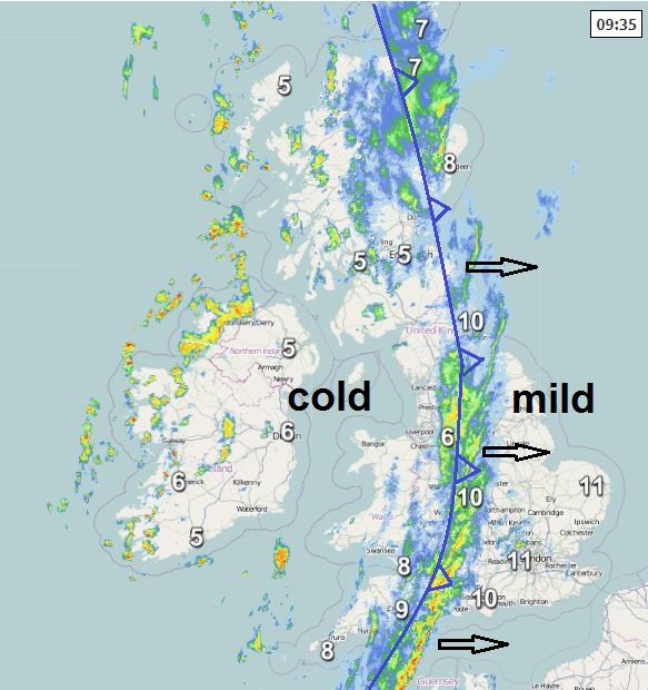
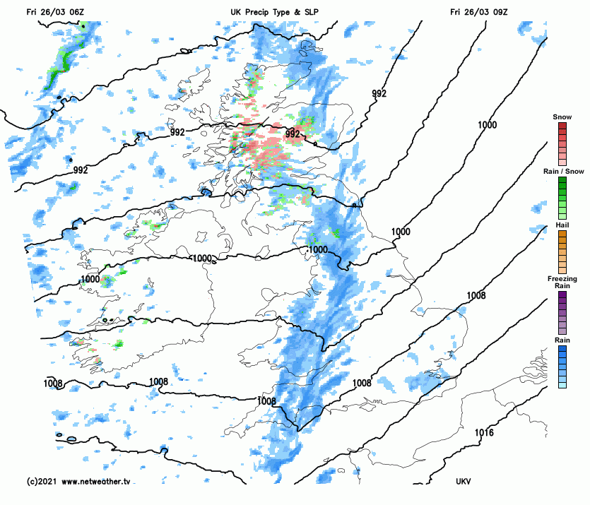
But behind the cold front clearing east, colder and clearer conditions will follow from the west, initially across northern and western areas through the morning, then towards eastern England through the afternoon too. But with the cold and brighter conditions will also be scattered heavy showers moving in from the west, with hail and thunder locally. Showers also increasingly falling as snow over northern and western hills, giving a covering over higher ground.
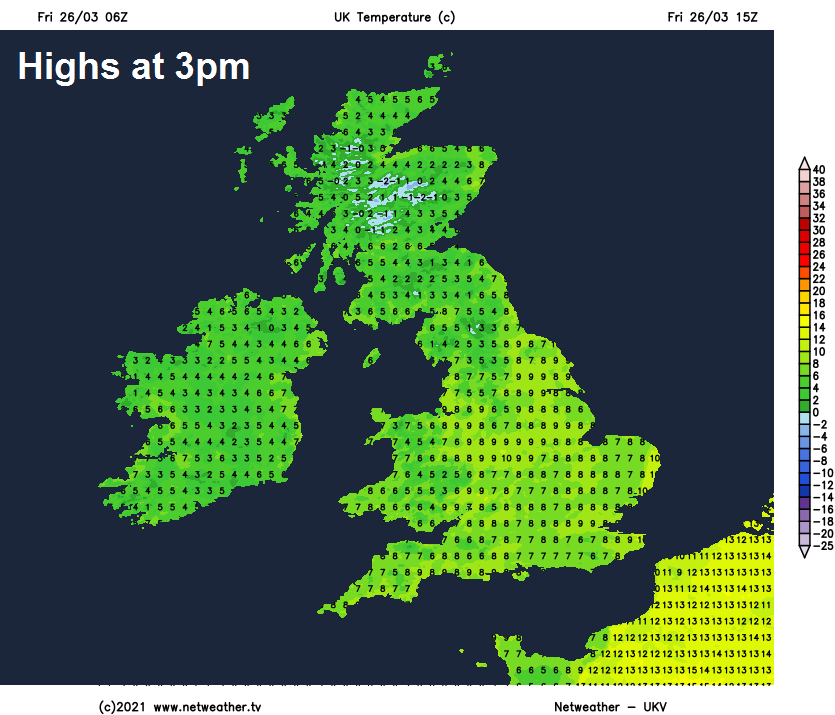
After a mild start in the east, temperatures as high as 11C across eastern England at breakfast time, temperatures will drop from the west following clearance of the cold front, with temperatures by late afternoon dropping into single figures widely, temperatures of 6-8C across most parts. Feeling colder than this in the wind.
Showers continuing overnight, most frequent across western areas but pushing towards eastern areas at times too, showers falling as hail, sleet and snow, wintriness even increasingly to lower levels in the south, bringing a dusting of snow over the southwest Moors and Welsh Mountains, more significant snow accumulations possible over the hills of North Wales, the Pennines, Lake District, southern Uplands and western Highlands. A risk of some icy stretches too, where showers have fallen and skies clear, with temperatures falling towards freezing, particularly in the north.
A cold start to Saturday, some places in the north likely to be waking up to covering of snow from overnight wintry showers, particularly over higher ground, so some icy stretches, perhaps a touch of frost and risk of ice on wet surfaces elsewhere. Some early wintry showers, particularly towards the northwest, but these will ease to join most places to drier conditions and increasingly sunny skies for a time. However, cloud will build from the west during the afternoon, with wet and windy conditions pushing in across N. Ireland and western Scotland before dark, while cloud thickens to bring drizzle or patchy light rain to western areas further south. Staying bright or sunny across eastern Scotland and eastern England. After the cold start, temperatures recovering to a milder 8-11C.
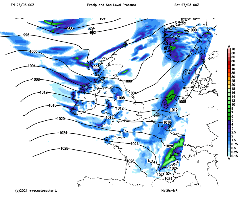
Remember the clocks go forward Saturday night. So we lose an hour of Sunday morning. Sunday looks like turning out to be a cloudy, wet and windy day for northern and central areas of Britain, the rain locally heavy and persistent at times over western hills from Wales northwards. Generally cloudy but mostly dry across southern areas of England, though some drizzle possible over southern counties and coasts. Milder across most parts though, temperatures reaching 11-14C. Colder air over northern Scotland will keep temperatures pegged back to 7-8C.
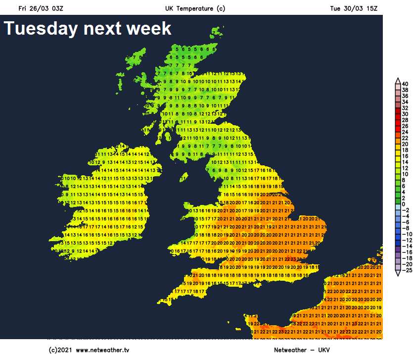
A warming trend as we head through early next week, cloud and rain pushing back north across Scotland and N. Ireland on Monday, with much of England and Wales away from the northwest turning drier and sunnier from the south as high pressure builds, temperatures reaching 14-15C in the north and west to around 18C across eastern England. Warmer still for some on Tuesday, we could touch 21-22C across central, southern and eastern England in sunshine covering much of England and Wales. But for Scotland and N. Ireland it will be cooler and cloudier with some rain.
Turning cooler and cloudier towards the end of the week, with cold northerly winds and showers, perhaps developing from Good Friday and lasting through the Easter Weekend. Showers may turn wintry in the north too.