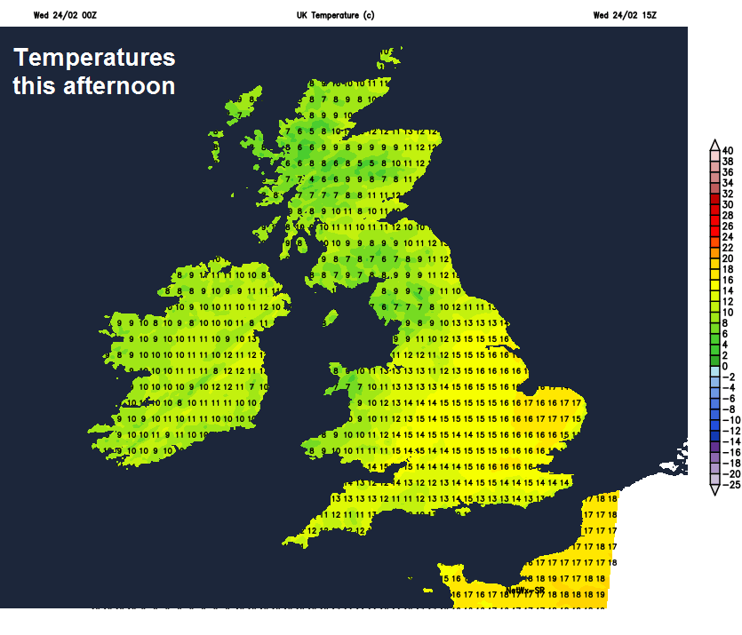
It will be exceptionally mild today, with temperatures reaching 17-18C across eastern England, but more rain for northern and western areas. High pressure builds from Thursday, so becoming dry and settled for all.
Tuesday saw a northwest – southeast split in the weather, with fine and sunny conditions towards SE England with temperatures reaching 15.6C in London, while northern and far western areas saw cloud and persistent rain, Patterdale in Cumbria seeing 115mm (over 4 inches) of rain over the last 24 hours. For all it was a rather mild day and Wednesday again looks set to be an exceptionally mild day, even where we see cloud and rain in the north and west. Potentially we could see the warmest day of the year so far, perhaps reaching 17-18C across eastern England. High pressure will build north towards the end of the week, so most places will turn drier and settled, not as mild as winds turn westerly, but temperatures still well above average. The weekend looks set fair, with high pressure centred over the UK, most places dry and fine with sunny spells, remaining mild too.
For now, a mild start everywhere 8-11C across Scotland, 11-13C across central and southern England. It’s still windy though, with gusts of 30-40mph in the west, though winds will ease through the day.
A band of cloud and rain streaming in from the southwest along a slow-moving cold front will bring an overcast and wet day for southern Scotland, northern England, Wales and far SW of England. Northern Ireland, central and northern Scotland turning drier and brighter after early cloud and rain. Further south and east, much of central, southern and eastern England will have a dry and bright day, with sunny spells, though with a fair bit of high cloud making sunshine hazy. Very mild for late February, temperatures reaching 13-15C widely across England and Wales, 16-17C across eastern England, perhaps reaching 18C with some sunshine. Scotland and Ireland reaching 10-13C.
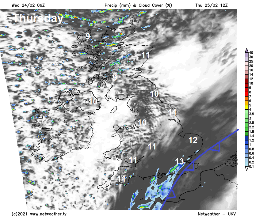
Outbreaks of rain across northern and western areas will ease eastwards through the evening, with some patchy light rain or drizzle reaching southern and eastern England overnight, turning largely dry from the west elsewhere across England and Wales, but staying cloudy. Southern and eastern Scotland along with N. Ireland seeing clear spells and a mostly dry night once cloud and patchy rain clears southern Scotland in the evening, though showers will affect western Scotland. A chilly night in the north, mild in the south.
Cold front slow to clear the southeast on Thursday, so SE England and East Anglia staying generally cloudy, with some patchy mostly light rain spreading northeast at times. Elsewhere across England and Wales, after a cloudy start, brightening up from the west to a largely dry and sunny day. N. Ireland, southern and eastern Scotland largely dry and sunny bar the odd shower, more in the way of cloud with showers over western Scotland. A westerly breeze, brisk in the north, so not as mild, but still temperatures above average, reaching 9-11C in the north, 11-13C in the south.
With winds falling light Thursday night in the south, perhaps some mist or fog patches here to start the day on Friday, but otherwise it will be a largely sunny and dry day for most as high pressure builds north, cloud will build through the day, cloudy with the odd spot of drizzle in the far north. Temperatures reaching 10-12C.
As we head into the weekend, high pressure will be firmly in charge of our weather, the anticyclone centred over the UK. So for most it will be dry and settled, sunny spells with variable cloud and temperatures above average in the low teens by day, but chilly overnight with a risk of frost and perhaps some fog patches developing. Perhaps thicker cloud with some drizzle over northern and western Scotland, as Atlantic fronts graze here.
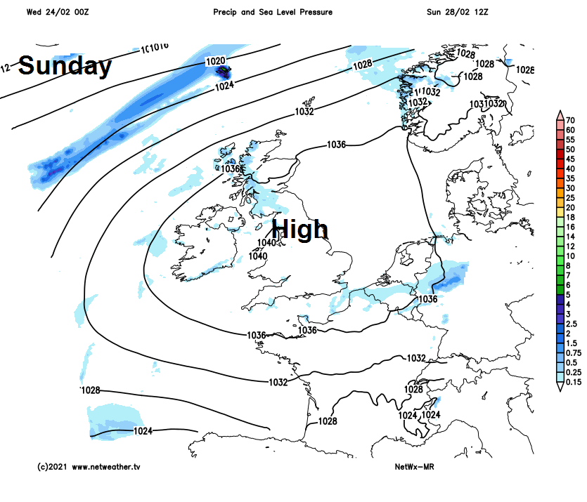
Dry and settled conditions look to continue through early next week too, with high pressure in control. Some uncertainty, but perhaps turning more unsettled from the west from mid-week as high pressure retreats east and Atlantic fronts move in.