A strong and bitterly cold easterly wind will blow in further snow showers to eastern and some central areas next few days, with sub-zero wind chill, before turning drier, sunnier but still cold after mid-week.
Sunday saw bitterly cold easterly winds arrive from Scandinavia in the early hours, which combined with Storm Darcy over the Low Countries, brought persistent snow to parts of SE England and East Anglia. North and East Kent along with coastal East Anglia were particularly hit – where up to 15-20cm of snow fell locally by the end of the day. Snow showers further north along eastern coasts also bringing some accumulations.
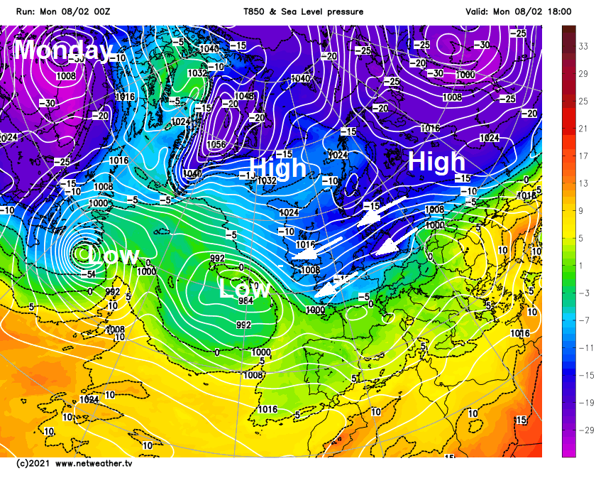
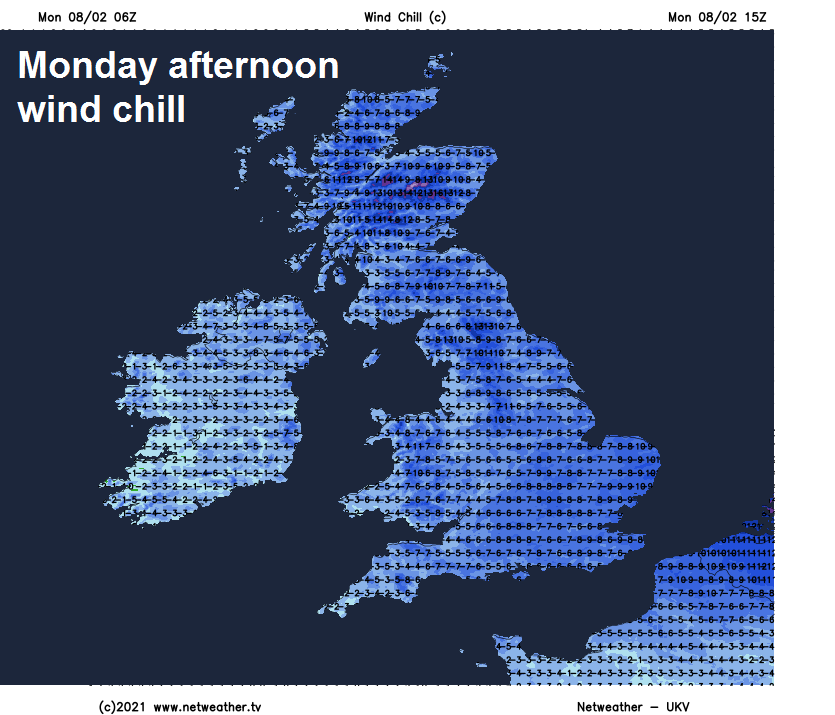
Monday will be another bitterly cold day with a sub-zero wind chill in the strong easterly wind. Further snow showers expected across eastern and some central parts through the day, bringing further accumulations, drier and sunnier in the west. The bitter easterly wind continuing Tuesday, with further snow showers in the east. Wednesday should see the easterly wind ease and with fewer showers in the east and more in the way of sunshine. Thursday and Friday are looking mostly dry, bright and cold, though rain or snow may move into the southwest and far west.
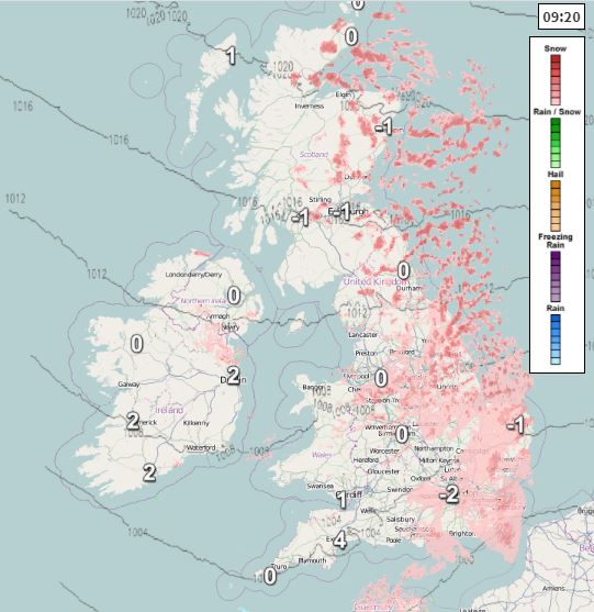
For now, cloudy with snow showers from the word go across many eastern areas, some light and some heavy. Some of the heaviest and most frequent snow showers this morning will be across northern and eastern England from Lincolnshire northwards – with a new Amber Warning issued by the Met Office in the early hours for parts of Lincolnshire and South Yorkshire. Snow showers moving inland across central and northern England. Eastern Scotland will see heavy snow showers at times, while it will snow on and off across East Anglia and SE England. Western areas drier and sunnier this morning.
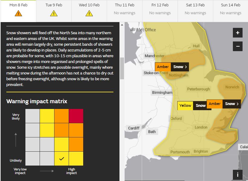
The strong easterly wind will continue to blow in generally cloudy skies and further snow showers across eastern Scotland, northern, central and eastern England through the afternoon, snow showers forming bands in places and locally heavy – particularly Lincolnshire northwards – where locally significant accumulations may build up. Amber Warning for Kent and coastal East Anglia if force until noon, Amber for Lincolnshire and South Yorkshire until 2pm. A general yellow warning for snow across eastern Britain in force until midnight Wednesday night. Western areas staying mostly dry and bright or sunny, though the odd snow flurry can’t be ruled out.
A very cold day, exacerbated by the strong easterly or northeasterly wind gusting to 30-40mph in places – strongest winds towards SE England and East Anglia and here will see temperatures around 0C and a wind chill of -6 to -7C. Elsewhere reaching 1-3C at best – with a wind chill of -3 to -5C. So wrap up well if you’re out. Drifting of lying snow will also be an issue, causing drifting on areas exposed to the wind.
Very cold overnight, temperatures below freezing widely leading to a widespread frost and ice forming on untreated surfaces – especially where there’s snow cover. Further snow showers in the east, merging into longer spells of snow in places and spreading in across central parts of England at times too.
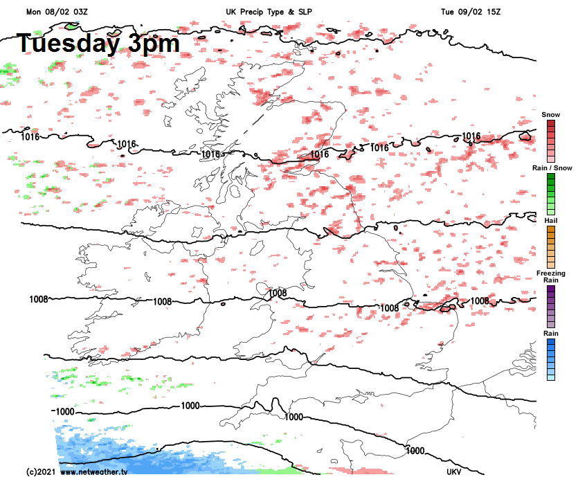
The strong cold wind continuing to blow in snow showers from the North Sea on Tuesday, wind tending to veer from northeasterly to more easterly, so some subtle changes in where see the most showers, with some bands of showers organising and moving inland through the Central Belt of Scotland, while also bands or streamers of showers moving further inland in from eastern England into central and southern parts too. Many western areas staying dry and sunny though. Temperatures reaching -1 to 3C at best, with a sub-zero wind chill feeling more like -3 to -5C.
Winds and showers easing Tuesday night and with clear skies, it will be a very cold start to Wednesday morning, temperatures widely -4 to -7C where there’s snow on the ground, perhaps below -10C in the Scottish Highlands. Wednesday itself seeing fewer snow showers and mainly near eastern coasts, with most places dry and sunny, also with lighter winds, meaning less wind chill. But, it will still be cold, temperatures reaching 1-3C at best.
Thursday’s looking mostly dry and bright or sunny but cold again after a hard overnight frost, just a few light snow flurries towards eastern coasts. Outbreaks of sleet or snow may spread in across SW England, south Wales and perhaps N. Ireland during the evening, before easing on Friday morning. Otherwise, Friday’s looking a mostly dry and bright or sunny day, but cold.