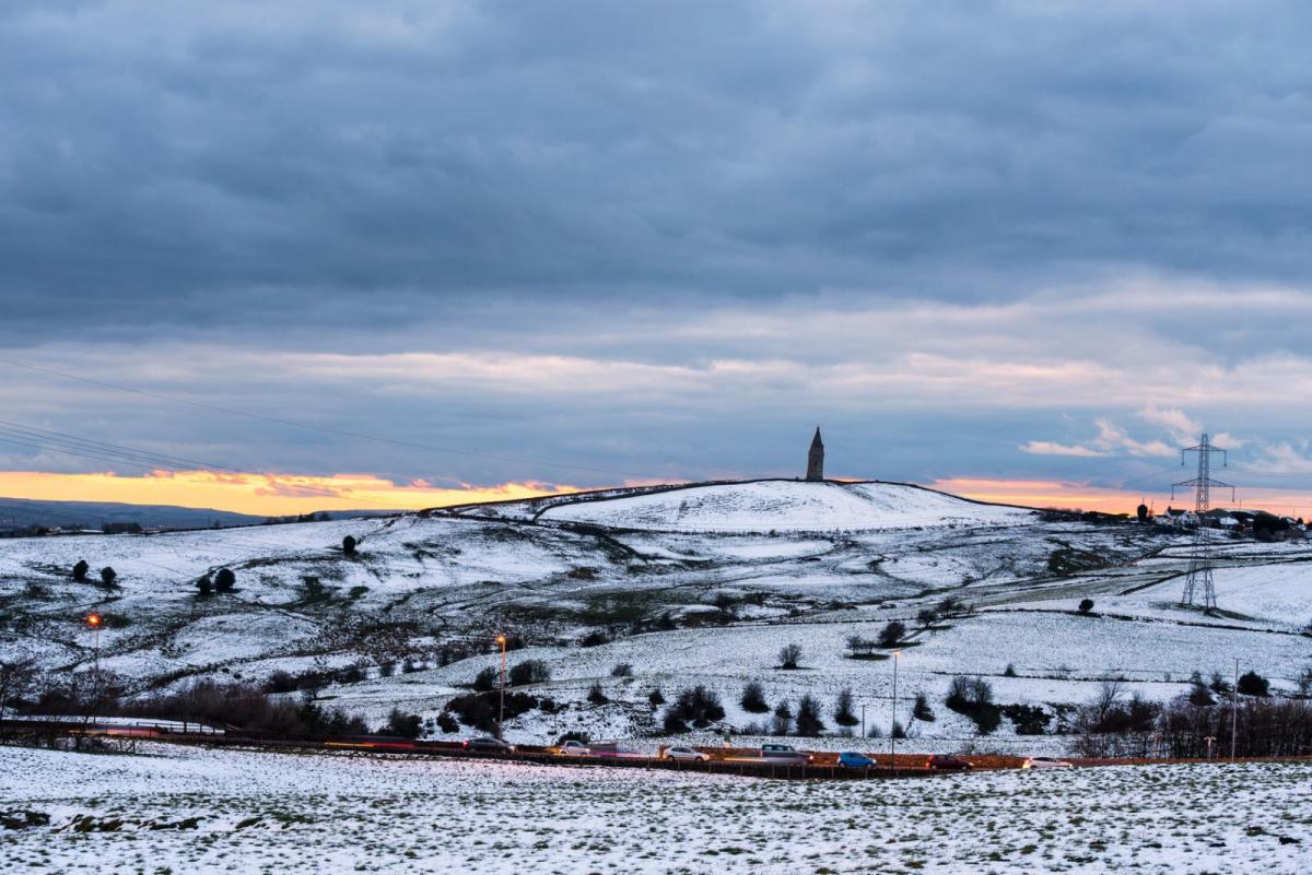
Still some snow in the north as Storm Christoph clears east over the North Sea, while risk of flooding remains in the north and west over the next few days. Colder but drier for most now and into the weekend.
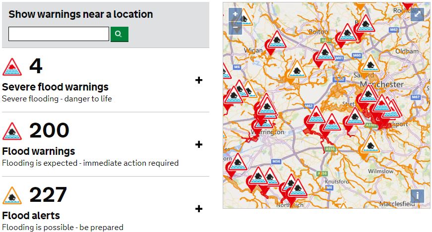
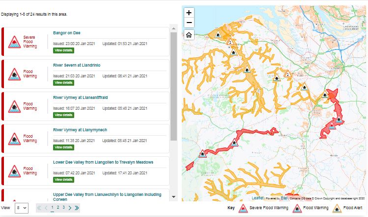
Storm Christoph is now out over the North Sea between Scotland and Norway, but its aftermath will still be felt over the next few days. Even though the warnings for snow and rain will lapse this morning, all the rain and snow that fell yesterday will take its time to work through the river systems, so there remains the risk of flooding. 5 severe flood warnings remain in force across NW England and north Wales, with 233 flood warnings. Heavy snow overnight and continuing this morning across southern and eastern Scotland along with the far north of England in wake of Christoph bring additional travel hazards this morning.
Severe Flood Warnings in force for England and Wales
Sleet and snow will persist for a time in the northeast, but generally it will be a drier, brighter and colder day for many, though with scattered showers in the west. It will remain on the chilly side tomorrow and through the weekend, dry and bright for much of the time, but there will be wintry showers in the northwest, Sunday could see a spell of sleet and snow in the south.
A cold start this morning, temperatures close to freezing across the north brings the risk of ice on wet surfaces following overnight rain or snow. But the main travel hazards facing northern and western areas are flooded roads and across the higher routes of southern Scotland and northern England – snow is causing some issues. Amber and broader yellow warnings for snow across southern Scotland and far north of England area in place until 10am and a separate area for snow across northern Scotland in force until noon too. Strong northerly winds could bring drifting and blizzard conditions as snow continues to fall here this morning.
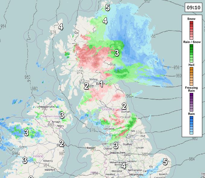
Wintry weather will continue to be an issue across Scotland this morning – particularly across southern and eastern areas, with areas of sleet and snow accompanied by a strong northerly wind persisting through the morning before easing across the south into the afternoon, though sleet and snow will continue across NE Scotland. Western Scotland drier and brighter, though a few scattered wintry showers possible, these brighter conditions spreading further east across southern Scotland this afternoon. A cold day, temperatures reaching 3-4C at best, but factor in the strong northerly wind and it will feel more like below freezing.
Further south, a mostly dry and bright day for eastern England bar the odd shower, further west a mixture of sunshine and occasional showers for Wales, western areas of England and Northern Ireland, showers most frequent in the northwest – where they will be wintry over higher ground. Outbreaks of rain could graze coastal areas of southern England later. Temperatures reaching 4-6C across northern England, north Wales and N. Ireland, 6-7C further south.
Persistent sleet and snow will clear NE Scotland this evening, but will be followed by wintry showers across the far north and west of Scotland overnight. Otherwise, most areas will have a dry and cold night, with clear spells leading to a widespread frost developing – which will bring a risk of ice on untreated wet surfaces. Some wintry showers possible near western coasts.
Friday will be dry and bright or sunny for many, on the cold side in a brisk northwesterly wind, which will blow in some wintry showers across the far north and western coastal areas. Temperatures reaching 3-5C in the north, 6-8C in the south.
Saturday is looking mostly dry and bright or sunny too, away from western coastal areas – where there will be some mostly light wintry showers at times – perhaps a few getting inland across NW England. An area of rain moving east through the English Channel could graze southern coastal areas.
Sunday will likely see more in the way of cloud spreading from the west, with models showing a frontal system moving east across England and Wales bringing a spell of sleet and snow for a time after a cold and frosty start in the east. Wintry showers following in the west. Scotland and N. Ireland mostly dry and bright, but wintry showers near northern and western coasts.
It’s looking like a cold and mostly dry and bright first half to next week, with a few isolated showers and risk of overnight frost. However, mid-week onwards may turn increasingly unsettled and milder, as Atlantic systems move in from the west.