The rain, sleet and snow will clear eastern England this morning, with a fresh northwesterly flow setting in across all parts. That continues through the weekend. Next week starts unsettled and milder, finishes still unsettled but colder.
A weather front moved in overnight, bringing rain to many parts but also some sleet and snow, particularly over Eastern and Southeast England this morning. What's left of that will clear through during the remainder of Saturday morning, to leave all parts in a fresh northwesterly flow for the remainder of the weekend. But, despite the relative chill, a thaw will set in away from the higher ground for those areas who have seen lying snow this week.
The low pressure responsible for the weather front is up to the northwest of Scotland currently, and it'll not move far through the weekend, just slowing drifting further north and a touch east, as it moves close to the east of Iceland into Sunday.
That will mean the blustery northwest winds continue across the northern half of the UK throughout, and it's also here where there'll also be the most showers - falling as sleet and snow up over the hills with the majority affecting the north and west of Scotland with some making their way further south and east at times. Further south across a good bulk of England and Wales it's a drier outlook for the most part, with lighter winds on Sunday as high pressure just starts to nudge up from the southwest.
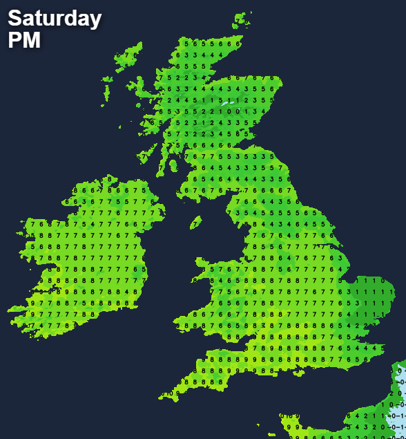
Temperature-wise, East Anglia and the far southeast will cling onto colder air today, with East Anglia, in particular, staying at an icy 1-2c this afternoon. Other parts will be milder than of late though with maxes of 4-8c quite widely. Where skies clear overnight, there's likely to be a touch of frost in places, but it'll be a fairly patchy one. Sunday will then see similar values to today, albeit with the milder air reaching right through into the southeast by then.
Looking ahead into next week, and it's looking likely to be a week of two halves. The first half will be fairly mild and unsettled with some spells of rain and wind at times. As low pressure moves over the country and then out into the North Sea during midweek, it's set to pull down colder air across the country. The weather will then stay on the unsettled side during the second part of the week, but with colder air in the mix, sleet and snow will be back on the menu. It'll not be for everyone, with higher ground always from Northern England and North Wales most favoured, but there could be some lower down and further south at times as well.