After the Christmas plans upset due to last weekend's announcements, there have already been plenty of adjustments to travel, food and parcel arrangements. The UK weather will be changing midweek as we hunker down. After another spell of heavy rain, it will turn much colder for everyone with frost on the way.
Food
For those whose Christmas food is in the right place or is just back from a busy supermarket and thinking there is no way all that can fit in the fridge, the weather will be helpful. It is turning colder.
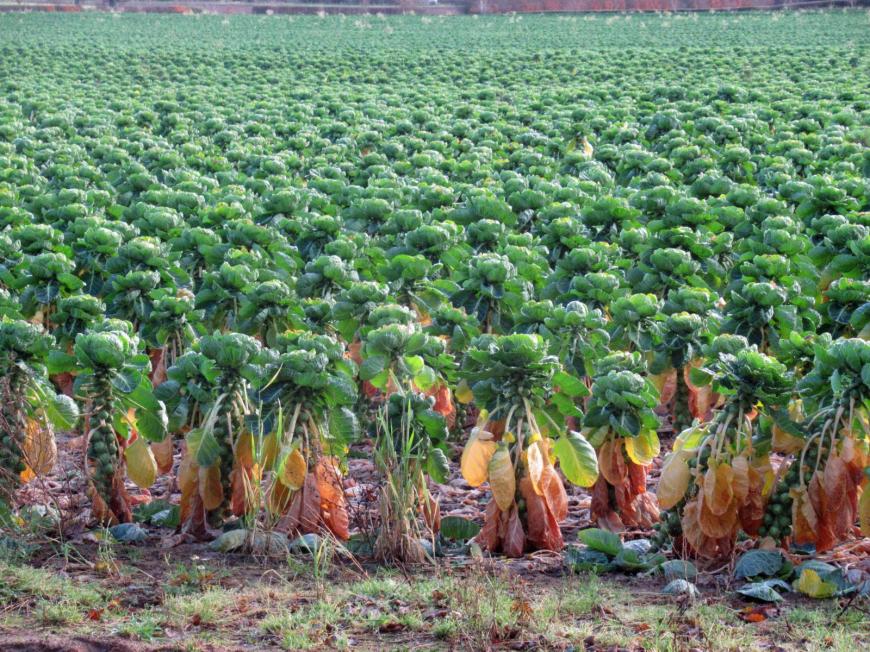
However, it is still very mild for southern England the cold air won’t arrive until Christmas Eve here but much of the UK is already seeing air temperatures around 5C and night time frosts will become more widespread by Christmas. A bit too late for the sprouts. This year you may have just gone for a smaller chicken, a non-microwave baked ham after watching Nigella or be helping the butcher’s out by buying up a large turkey. That will need to be stored somewhere cold but secure and the dipping temperatures may help. Don’t give your household food poisoning though and for those who had ended up with a big bird, good luck with the inventive turkey recipes for the rest of lockdown.

The major shift in the temperatures occurs midweek. However, there is a continued risk of flooding as more heavy rain heads in for the 23rd, heaviest during Wednesday night. The ground is already sodden and river levels high particularly for SW Britain and the Met Office with the Environment Agencies do have concerns.
If you haven’t already sign up for the flood warning service, it doesn’t take long just needs a postcode. The heaviest rain is expected through Wednesday night leading into early Christmas Eve. The Environment Agencies have been reminding people not to pour grease and fat/cooking oil down the sink this Christmas and that includes any leftover gravy. Leftovers into the food waste or bin and avoid blocking up the nation’s drains and sewers. It is harmful to the environment, can cause fatbergs and adds to the risk of sewer flooding which considering the current conditions do not need the extra strain.
Travel
Most travel plans have been curtailed so the usual huge traffic surge and Christmas get-away isn’t expected this week, although Christmas Day roads may not be as quiet as usual with people using the short window to visit local friends or family.
Road conditions to watch this week will be the heavy rain, surface water and spray, localised flooding and then the change to frost and ice.
For the next few days, trips to the supermarket and high street will dominate within the restrictions. Rain is already showing itself over south Wales and through the English Channel.
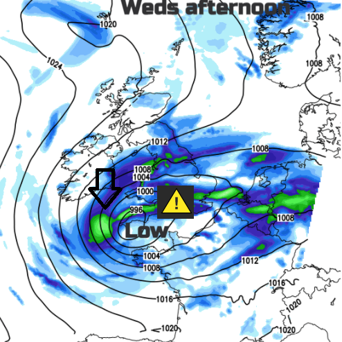
If you are heading out on Wednesday it looks very mixed for southern Britain. SE England could see spells of fair weather with sunshine then showers. However, as the winds pick up a swathe of England and Wales sees heavy rain and some horrible weather. It will really be worth avoiding this as the gusty winds set in for the Peak District, western Wales, Cornwall and the Channel Islands before dark. Might be worth checking any outdoor lights are secured depending on how professional you were about fixing them up.
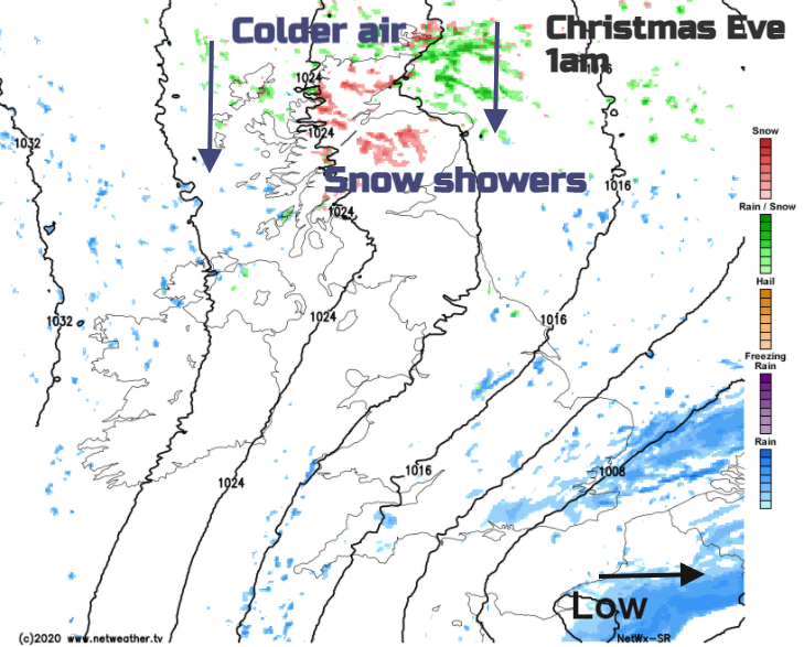
A cold northerly wind takes hold through Wednesday night as snow showers arrive over northern Scotland. Wintry showers clip North Sea coasts in the flow on Christmas Eve.
There is also the low sun angle to contend with at this time of year. Southern Britain under all the midweek cloud and rain may be longing for a bit of winter sunshine but for northern Britain and Northern Ireland already getting the colder, clear air, it’s easy to be suddenly dazzled.
Schools have broken up or are now finishing so that traffic is also subsiding but the gritters are finally having something to do after a mild and wet few weeks. Although we had the odd morning frost and that brief snow occurrence, many of us won’t have actually sorted the de-icer this year or adjusted windscreen wash from its summer dilution. Winter is coming
Getting out and moving
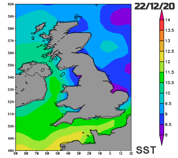
For cyclists and walkers getting your clothing right in winter can be tricky, especially now refreshment stops are mostly outside and you can get chilly very quickly. It is going to be much colder by Christmas, especially noticeable for southern England where it has been very mild in recent days. There will also be frost and so the risk of ice underfoot, for cyclists and other road users. The brisk north or NW winds will bring a chill, especially over the hills and there will be a bit of snow for the mountain tops. You might have been lucky enough to get a lane or ‘tank’ booked at a local swimming pool if that is your thing, but others are still going in the sea, lakes or rivers for wild swimming. Of course, the New Year’s Day organised dips will be off but if you are interested, the surface sea water temperatures around 10 to 8C currently. Edge in slowly.
For those who just fancy getting out of the house to stretch their legs, get some fresh air, a change of scene, unleashing the sugar fuelled children or exchanging presents in a park, it does look drier but cold.
Wednesday looks wet for England and Wales with strong, cold winds developing for western parts. The rain bands will drench some areas but keep gaps in between. With all the recent rain and ground/river conditions there is the risk of flooding. Still mild in the far south but not feeling great in the wind and rain, colder for northern England and north Wales. Even some wet snow for Snowdonia and the Pennines later. For much of Scotland and Northern Ireland, it will be brighter, colder with snow showers appearing for northern Scotland later in the day.
Thursday/Christmas Eve – Frosty in places and ice. Much colder everywhere but brighter. Wintry showers in the brisk northerly flow but these fade as high pressure builds in from the west.

Cold overnight for Santa and his reindeer, they will need the snacks and refreshments. More cloud over the NW Highlands as rain and wintry bits topple in but for most Christmas Day looks fine and bright but cold after a frosty start where the winds have eased. A chance of a flutter of snow from the odd shower caught in the last of the north to NW winds but no blanket of snow this year.
Hope for new socks, thermals and a woolly hat, it will be cold out there.
Loading recent activity...