After a brief 'cold' snap, milder air, cloudy skies and rain return today. Staying mild into the weekend, with band of rain sinking south Saturday, drier conditions following with Sunday mostly dry.
The brief cold snap yesterday is on its way out this morning, as low pressure to the northwest of Britain pushes a warm front eastward across the UK today, bringing cloudier skies, rain and milder air from the west. It remains mild for most on Saturday, a frontal system will sink south, bringing a spell of rain, followed by blustery showers and gales in the northwest. Sunday will be dry and bright or sunny for most, though less mild, blustery showers for the northwest again. Next week looks to turn increasingly unsettled across all parts, rain in the north and west to start the week drier in the east before spells of rain affect most parts from mid-week, but with some drier weather and generally remaining mild.
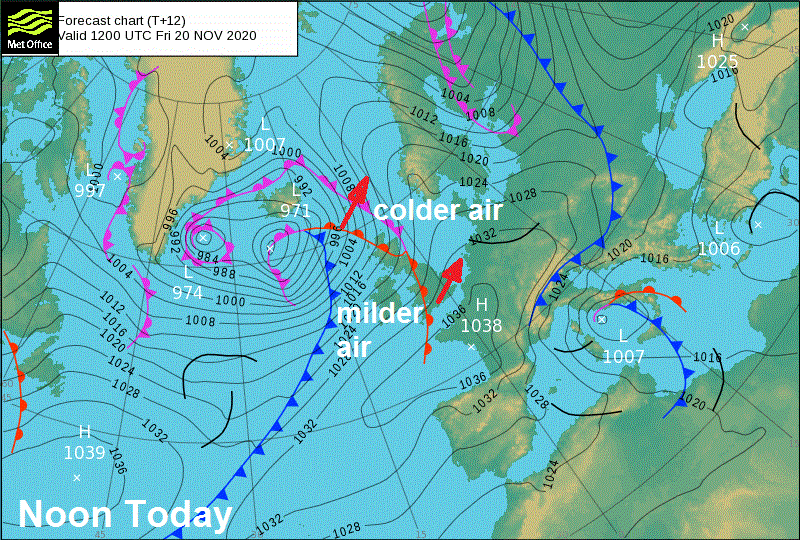
For now, there’s quite an east-west contrast in temperatures at dawn this morning. Under clearer skies, eastern Scotland and eastern England are close to or below freezing, with a frost in many places, while in the far west, such as Pembrokeshire, NW Wales and the Isle of Man – temperatures are in double figures – as cloudier skies and rain moves in across the west. The lowest temperature overnight was -5.2C at Aboyne in Aberdeenshire.
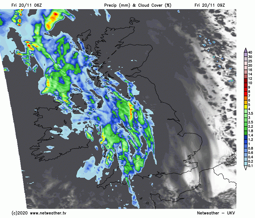
Cold, bright and frosty conditions in the east will be replaced by cloudier skies through the morning, as outbreaks of rain along a warm front across the west at breakfast time, locally heavy, edges east, reaching eastern parts later this morning, but tending to fragment and turn lighter as it does so. A cloudy and milder afternoon for all, with patchy outbreaks of rain clearing east, followed by increasingly misty conditions with patchy outbreaks of light rain or drizzle over western hills. More persistent rain lingering across northwest Scotland, thanks to a trailing cold front.
Temperatures perhaps struggling to reach double figures today across the far east of England, as cloudier skies moving in traps the cold air from first thing, while elsewhere milder air flooding in from the west will allow temperatures to reach 11-13C this afternoon.
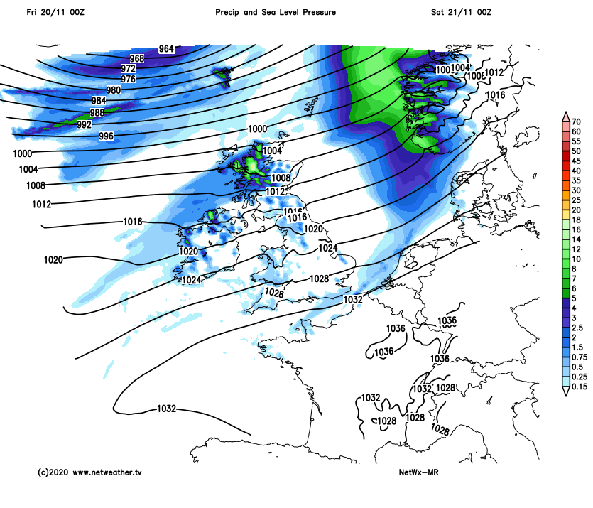
A generally cloudy and mild night for England and Wales, with some patchy drizzle in places. A cold front bringing a band of rain will slide southeast across Scotland and N. Ireland, followed by colder, clearer but windy and showery conditions across northern and western Scotland, gales developing towards the northwest.
The cold front with its band of rain will continue to slide slowly southeastward from Scotland and N. Ireland across northern England and Wales through Saturday morning, before reaching central and southwestern England through the afternoon. Generally dry, cloudy and mild to the south of the front, but with some breaks allowing some bright or sunny spells. Following the front, clearer, cooler and windier conditions will spread southeast across Scotland, N. Ireland and eventually northern England, but with squally showers and gales affecting the northwest. Temperatures reaching 9-11C across Scotland and N. Ireland, 12-14C across England and Wales.
That cold front lingering across the far south of England on Sunday, bringing a cloudy and mild day with patchy light rain or drizzle. But for much of Britain it will be a bright or sunny but cooler day, dry for most too, but showers and strong winds will continue to affect northern and western Scotland – where it will be windy too. Temperatures reaching 8-9C at best away from southern counties of England and Wales – where temperatures will reach 10-11C.
It’s looking generally cloudy on Monday after perhaps a bright start for eastern England, windy with outbreaks of heavy rain spreading east across Scotland, N. Ireland and northern England through the day, patchy rain or drizzle increasingly affecting Wales, Midlands and SW England too, SE England and East Anglia perhaps staying mostly dry.
Further rain, perhaps heavy, affecting northern and western areas on Tuesday and windy too. Central and eastern England perhaps staying dry and bright. Mild everywhere. Remaining unsettled but generally mild for the rest of the week, with further spells of rain or showers at times, but also some drier and brighter interludes.