


A look at the UK weather this week but also tropical developments in the extreme 2020 hurricane season.
The first half of this week did some hefty showers in the south but plenty of quiet, calm conditions thanks to high pressure away to the southeast. For the rest of this week, into next, it will be about low pressures whizzing by to the northwest bringing plenty of frontal rain, particularly for western Scotland. There will be stronger winds, from the south bringing mild air but veering to a fresher westerly for a time too. The Atlantic low pressures or cyclones are causing quite a stir this week elsewhere as this season passes the most named storms in a hurricane season.
Extra-tropical Lows
Parts of Scotland have a yellow rain warning for Wednesday and overnight. There will be plenty more rain to come as a series of low pressures run in from the Atlantic. The high manages to offer some protection for southeastern Britain midweek but there will be lulls in between the rain bands too.
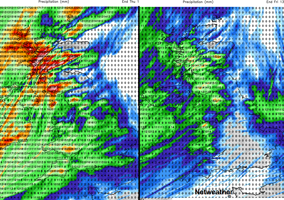
After a spell of wet and windy weather to end Wednesday, Thursday starts off calmer, clearer and feeling fresher with sunshine. However, by the evening another active front heads in from the west, again with squally line convection. This shows as a distinct bright line on the radar as sudden very heavy rain hits, with gusty winds, sometimes even lightning.
That clears and leaves a brighter, breezy Friday before further spells of heavy rain and blustery winds rattle across the UK this weekend. The bands do move through quite quickly later this week but the continual soaking from the west could lead to surface water issues, even travel disruption.
Tropical Cyclones
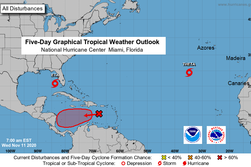
The Atlantic hurricane season continues to break records, long-lasting Eta threatens more heavy rain for Florida. this was the one which hit Nicaragua as a Cat. 4 in early November. It is now back at hurricane strength once more, to the west of Florida and then will make landfall as a Tropical Storm on Thursday. There are concerns about a Storm surge, high rainfall totals and flooding with western Cuba still seeing heavy rains. Even after moving inland, the forecast takes Eta out over the Atlantic, much weakened but still not quite finished.
"However, it would take only a small forecast error to allow Eta to come ashore as a hurricane, and hence a Hurricane Watch has been issued." NHC
Closer to Europe is Tropical Storm Theta, the 29th named storm this season, the most on record. Beating 28 storms in 2005 Atlantic and 27 for the eastern Pacific in 1992. This is further east heading closer to Madeira. It is not expected to cause much impact but could feed warmer air up from the south, even to the UK
The next name is Iota, with signs that the next tropical cyclone will appear soon in the Caribbean Sea. 2005 was the previous most active Atlantic year and the named storms were still appearing in December. It's not over til the Fat Lady sings.


