Thanks to low pressure to the east of the UK, we have an East to West split in the weather this weekend. With those in the east seeing the majority of the showers and the gustiest winds.
Thanks to low pressure to the east of the UK, we have an East to West split on the go this weekend with all parts feeling chilly in northerly winds. But, it's eastern counties seeing the vast majority of the showers, which will be at their most frequent and widespread during Saturday, along with the gustiest winds. It'll be western regions seeing the best of the sunshine over the weekend, but the pay-off for that will be clearer skies overnight, allowing temperatures to dip low enough to bring some patches of frost.
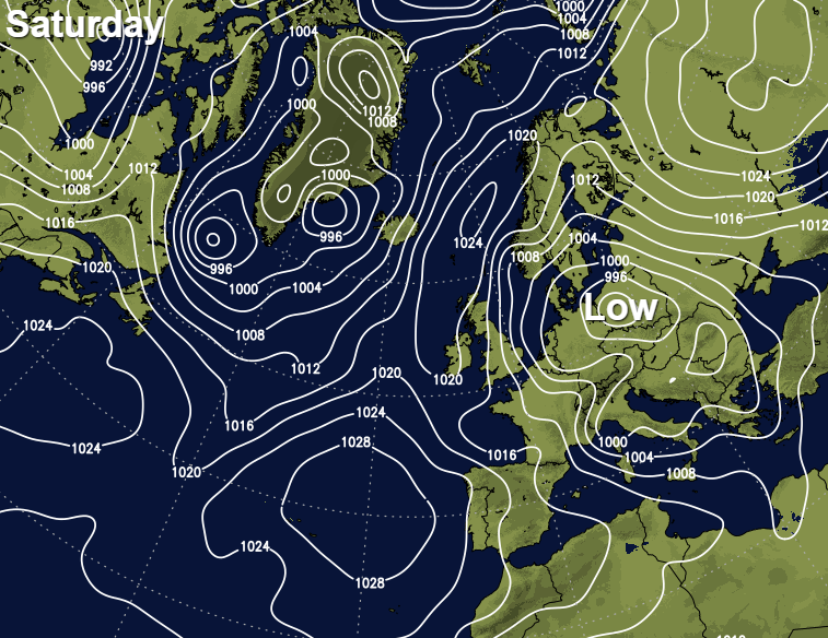
Those nagging winds will stick around through much of the weekend in eastern and southeast England, whereas they'll begin to fall lighter elsewhere. Those eastern showers will ease on Sunday too, with just the far east and southeast potentially catching the odd mostly light one.
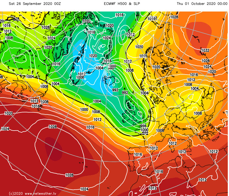
Looking further ahead, next week will start on a quieter note, albeit with some patchy rain moving southeast during Monday and into Tuesday. But, it's not going to carry on that way as Atlantic low pressures will be back on the scene for midweek bringing some wet and windy weather with them. And that unsettled weather theme is then set to stick around right through into the weekend and very likely beyond.
Temperature-wise, this weekend will be a far cry from last weekend when we saw highs into the low, even mid-twenties for some. This time around, if your area makes it into the teens today you'll be doing pretty well, and in the east, once you take the wind into account, it'll be feeling more like single figures. Sunday will be a touch warmer in central and western parts at least with highs of 14-17c typical for England, Wales and Ireland. Scotland and eastern England will still be colder though, with maxes of 10-14c generally.
Overnight, with extra cloud cover most eastern parts won't see temperatures dip very much, but head west and lows will fall away into single figures. Parts of Northern Britain and Ireland will be colder still, into the low single figures, even sub-zero locally with frosts developing.
Milder air will arrive to start next week, with temperatures moving up into the mid to high teens. Even once the wetter, cloudier and windier weather turns up from midweek, it'll be warm enough during any brighter, drier spells - these likely to be most frequent in the southeast.
All in all, we're definitely into a changeable Autumn weather theme now with a little bit of everything on the way during the coming days. If you have outdoor plans or work to do in the garden, it'll probably be best to get those out of the way sooner, rather than later though, as the weather will certainly be taking more of an unsettled turn from Wednesday onwards.