A Monday lull before rain and gales sweep in on Tuesday, drier Wednesday then wet weather returns for Thursday and Friday.
The general picture for this week is one of changeable conditions. Monday will see some showers in the south and east of Britain, but elsewhere mostly dry and sunny. Then on Tuesday, a deep area of low pressure, similar to last Friday, swings northeast across Ireland and northern England, bringing gales and heavy rain. Winds will ease and it will turn drier Wednesday, as a ridge of high pressure builds. Then it’s all downhill again on Thursday, as another area of low pressure moving across southern Britain brings outbreaks of locally heavy rain across England and Wales, then showery on Friday, though Scotland perhaps drier and sunnier with just a few showers.
For now, a rather cloudy morning across southern England, south Wales, Midlands and East Anglia, with showery outbreaks of rain moving east, mainly across southern England, some heavier bursts possible, maybe with the odd rumble of thunder too. Cloudy this morning with some showers over NE England, central and eastern Scotland too, but elsewhere and generally dry picture, with some sunny spells, best of which will be across NW England, SW Scotland and N. Ireland.
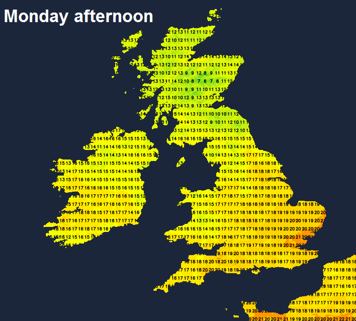
Cloud and showers across the south this will eventually clear east through the afternoon, to leave a drier and brighter evening. Showers continuing through the afternoon across eastern Scotland and NE England. Otherwise, the same areas that are dry and sunny this morning will continue so this afternoon, with the addition of most western areas that may have started cloudy this morning. Winds mostly light today, temperatures this afternoon reaching 14-17C across Scotland and N. Ireland, 17-21C across England and Wales, highest temperatures towards SE England.
Becoming mostly dry with clear spells for a time this evening. But outbreaks of rain and strengthening winds will arrive across SW England and Wales by midnight, before heavy rain and windy conditions quickly spread northeast in the early hours across England, Wales, N. Ireland and southern Scotland – ahead of a deep area of low pressure arriving across SW Ireland.
A wet and windy Tuesday morning commute across much of England, Wales, N. Ireland and southern Scotland, with some tricky driving conditions with surface water and spray on roads. Outbreaks of heavy rain and strong winds continuing to spread north and northeast through the morning across Scotland, northern England and N. Ireland while clearing to blustery showers across southern areas.
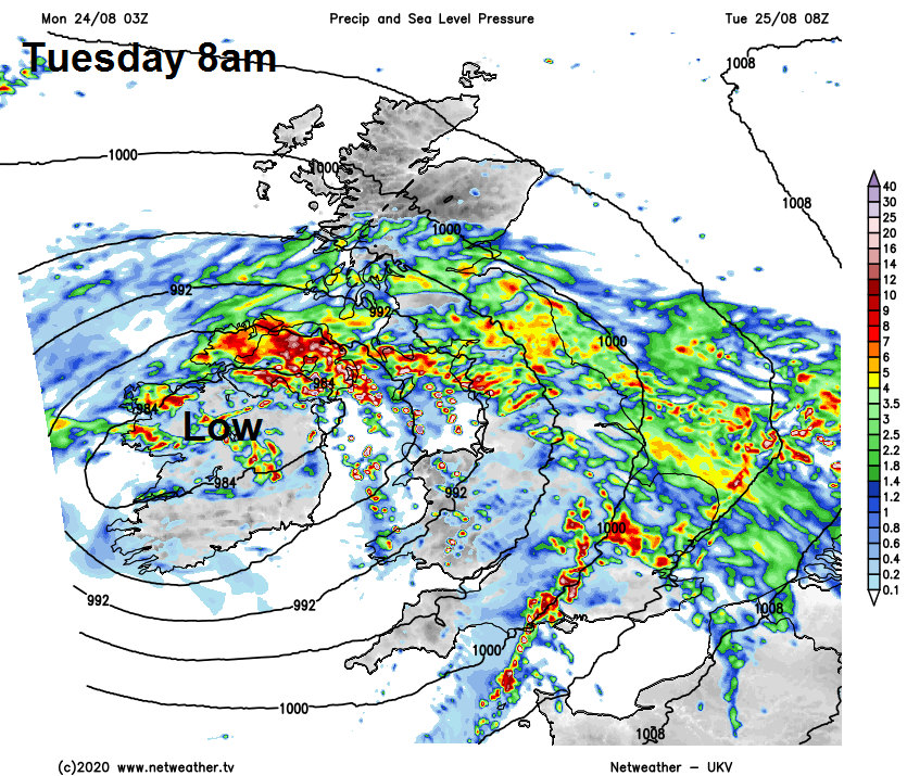
Outbreaks of rain, locally heavy, will linger across Scotland, N. Ireland and northern England through the afternoon as it wraps around low pressure tracking east across northern England. But becoming drier and sunnier with fewer showers further south. Temperatures rather disappointing across the north in the lingering rain, reaching 12C in Aberdeen, 15C in Glasgow, 16C in Newcastle, 17C in Belfast. Warmer for southern areas, reaching 20-21C.
Strong to gale force southwesterly winds developing across England and Wales into the afternoon, as that low moves across the north. Strong to gale force easterly wind affecting central and eastern Scotland north of the low. Gusts of 40-50mph quite widely inland, locally 50-60mph, along southern and western coasts of England and Wales we could see isolated gusts of 60-70mph. So there is a risk of big branches or small trees falling given trees in fall leaf, disruption to transport and perhaps power supply interruptions. The Met Office have a yellow wind warning for much of England and Wales in force between 0900 Tuesday and 1200 Wednesday.
Tuesday’s low pressure moves off east over the North Sea towards Denmark on Wednesday morning, but there will be tightly packed isobars down the eastern side of Britain in the low’s wake, bringing a windy morning towards eastern coasts, with some showers. But winds and showers will ease in the east by the afternoon to join most other places having a dry day with variable amounts of cloud and sunny spells. Temperatures reaching 14-17C in the north, 18-21C in the south.
Then after a mid-week respite, turning more unsettled again on Thursday, with showers spreading northeast across N. Ireland, Scotland and northern England while further south a new area of low pressure will bring outbreaks of heavy rain and gusty winds across Wales, southern England and the Midlands through the afternoon after a dry and sunny morning.
Outbreaks of rain or heavy showers and windy conditions lingering Thursday night and through Friday across England and Wales, turning drier and sunnier for Scotland and N. Ireland after perhaps some morning showers.
Main photo today: Neist Point, Isle of Skye