


Severe thunderstorms bringing torrential rain and flooding, with incredible lightning shows and hail. Along with extreme heat as temperatures continue over 34C for days on end.
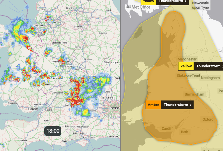
Once again vigorous thunderstorms are breaking out for parts of Britain. A crop of Cumbria and western Wales and many clusters west and north of Greater London bringing welcome rain and relief from the incessant heat but perhaps too much rain in one go as the ground is so hard. An amber warning has been issued by the Met Office at 6pm Weds 12th for thunderstorms this evening. The risk of severe thunderstorms remains for Thursday and there are other warnings for Friday & Friday night and again on Sunday into Monday for England and Wales.
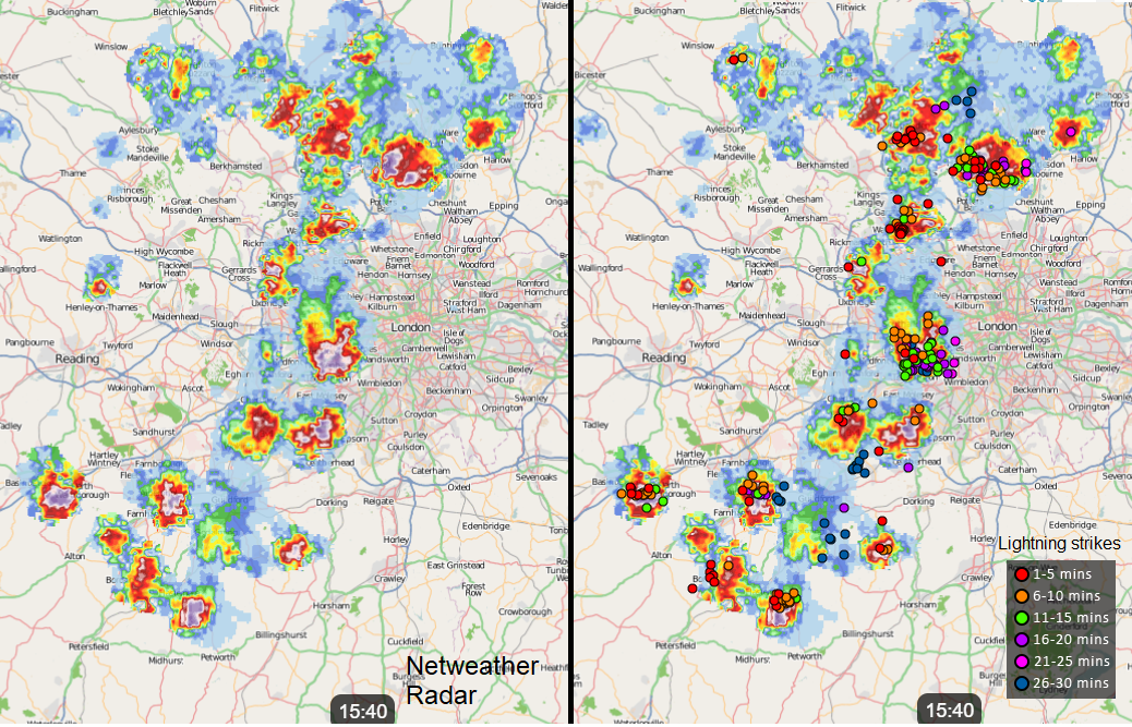
All of this area, shown on the radar, was under a thunderstorm warning, but from the nature of convective cells, some areas stay dry and others get rain. Lots of rain in this case due to the masses of available moisture in the atmosphere and the extreme heat. And lightning and even hail.
Heatwave conditions - The UK has now seen six days with temperatures of 34C or above, not seen in at least 60 years. Temperatures did reach over 30C for longer in the mid-70s but this run has also seen three consecutive days of over 35C which doesn't happen very often either. Our warming UK climate along with global heating. There have also been Tropical Nights, where the temperature does not dip below 20C overnight, a concept that the UK Met Office has been recording since 2018. The high heat will be easing down for the end of the week. Still with very warm air in places but not the extreme conditions of recent days
vid
There have already been severe thunderstorms, bringing incredible lightning shows by night, torrential rain and on Tuesday night flooding and damage. Part of the A68 broke away, a hospital car park flooded overnight where staff had parked for nightshifts and after scenes of flooding in Aberdeenshire, news that a Scotrail train had derailed not far from Stonehaven. Devastating news after an incredible night of storms.
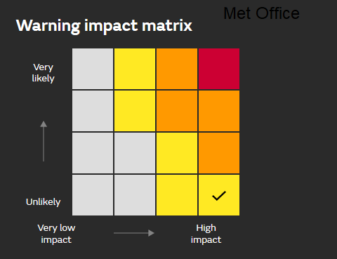
The widespread warning areas have tried to highlight the risk, yet low likelihood of seeing a storm. And with a severe storm comes the risk of torrential rain and so flooding, flash flooding a particular risk in the slow-moving storms and where the ground is bone dry. Frequent lightning, hail and sudden gusty winds. The impacts can be high if one thunderstorm cell, or lines of these storms (as happened for eastern Scotland) appear.
You may have found the warnings frustrating if waiting for rain or a storm but these two aspects have to both be considered for convective cells in any one location. Identifying key areas of risk is tricky, the Netweather Convective forecast is updated in the morning to show different risk areas and then it is a case of watching the radar to see where the storms pop up. Using the 700hPa forecast winds to see how they might be steered or just using the animation on the radar to see their progress so far can show the general motion.
More storms and downpours to come even as the most intense heat subsides, keep an eye out for some stunning cloud tops, lightning and even large hail, if you have any energy left.


