We tap into some very hot air building over the near continent to end this week, 35C is possible in the southeast tomorrow. Cooler and fresher weather over the weekend.
For much of July, temperatures have been close to or a little below average, thanks to cool and often cloudy conditions flowing off the Atlantic. However, as the month draws to a close, high pressure building over the near continent and low pressure stalling to the west will drag in hot air from the south. The heat is building today across France, where across the west it could reach 36-40C, locally 41C, then we tap into this heat tomorrow, with 34-35C possible across London and SE England. Low pressure to the west will win out over the weekend though, with a cold front moving east Friday night clearing the hot air away and replacing it with a cooler and fresher westerly flow with sunny spells and showers, mostly in the west.
Heat building across France today, Britain will tap into this heat on Friday, with 34-35C possible in SE England.
For now, a north-south split this morning, warm sunshine under blue skies spreading north across England and Wales, cloud and rain this morning from northern England and N. Ireland northwards across Scotland slowly spreading north. Though a bright and mostly dry start across the far north of Scotland.
Into the afternoon, rain will become increasingly confined to Scotland, while clearing north from northern England and N. Ireland, promising a drier and brighter afternoon with increasing amounts of sunshine from the south here. Though a few showers are possible for N. Ireland. The rest of England and Wales enjoying a fine and very warm day, hot towards the southeast, cloud will build after blue skies to start in the south, but generally plenty of sunshine, blue skies in the south.
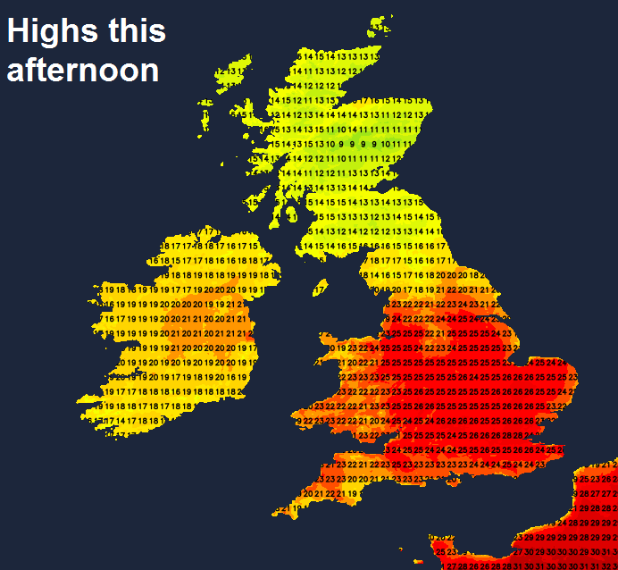
Temperatures this afternoon reaching 14-17C at best under the cloud and rain across Scotland, further south in the sunshine increasingly warm the further southeast you go, with highs of 19C in Belfast and Newcastle, 25C in Manchester and Cardiff, 26C in Birmingham and Norwich, 28C in London.
Rain becoming confined to northern Scotland this evening before clearing north after midnight to leave a dry second half of the night with clear spells. The rest of the UK dry and warm with lengthy clear spells tonight. Temperatures falling no lower than 12-14C across the north, 14-16C across the south.
Much of Britain dry with plenty of sunshine through the morning and into the afternoon and with a southeasterly breeze dragging in air from a very hot near continent. Temperatures will soar across England and Wales under mostly clear skies as a result, reaching 28C in Newcastle and Cardiff, 30C in Manchester, 31C in Birmingham, 32C in Norwich, 34-35C in the London area.
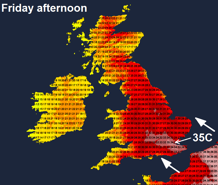
However, a cold front moving across Ireland and N. Ireland through the morning will bring a band with pulses of rain east, perhaps locally heavy and thundery, the band reaching the far west of Scotland and Wales into the afternoon. Meanwhile, the heat could trigger a few isolated thunderstorms across SE England, East Midlands and East Anglia in the afternoon, with perhaps some thundery showers spreading northeast across the eastern English Channel to affect Sussex, Kent and Essex from late afternoon through the evening.
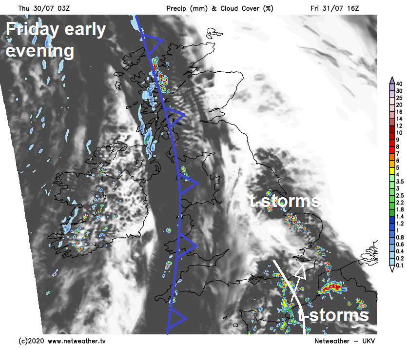
A cold front arriving across the west tomorrow evening will continue east Friday night, bringing a band of showery rain east across northern areas. Front weak across the south, so bringing little rain here, but it will introduce cooler and fresher conditions from the west as the front clears eastern areas in the early hours.
Saturday will feel noticeably fresher and more comfortable across England and Wales following the heat of Friday. A mixture of sunny spells and scattered, mostly light, shower blowing through on a fresh westerly breeze across most parts. Sunday pretty similar, with a day of sunshine and showers, though showers mostly across the west. Thicker cloud and rain could reach far SW of England and SW Wales by evening.
Looking unsettled and cool next week, with areas of low pressure moving west to east off the Atlantic across the UK, bringing some rain to the south on Monday, then another low bringing more widespread rain and perhaps windy conditions mid-week.