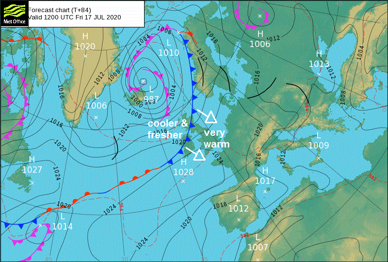
Atlantic fronts will bring a lot of cloud, some occasional rain or showers and subdued temperatures next few days, but sunnier and warmer weather for England and Wales by Friday.
Sunshine will be in short supply over the next few days, thanks to a succession of Atlantic fronts rolling in from the Atlantic bringing a lot of cloud and some patchy rain or drizzle across many areas. The cloudy and damp conditions will persist across Scotland, N. Ireland and NW England through Thursday and Friday, with rain pepping up as a cold front moves in on Friday. However, there will be increasing amounts of sunshine across central, southern and eastern areas, with temperatures reaching the mid to high 20s Celsius across the southeast on Friday. The return of summer will be brief though, as the cold front arriving in the north Friday continues southeast across all parts Saturday, taking cloud and rain with it. Cooler and fresher after the cold fronts clears the south with sunny spells and a few showers on Sunday.
For now, cloudy across most parts at breakfast time, a little patchy light rain or drizzle across the far southeast left over from overnight rain across the south, but for most it’s a dry start, some sunshine towards coasts of eastern Scotland and eastern England.
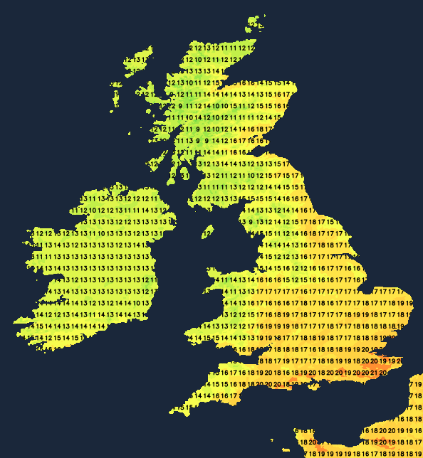
It will stay largely cloudy through today, dry for many, but there will be a few well-scattered showers breaking out, particularly late morning into early afternoon. More persistent rain spreading southeast across N. Ireland through the morning, before rain crosses the Irish Sea to reach SW Scotland and west Wales this afternoon. Best chance of seeing some sunshine towards eastern coasts of Scotland and England and perhaps far SW of England. Temperatures this afternoon down on those experienced on Monday, when Essex reached 26C, today reaching 15-17C across Scotland and N. Ireland, 16-20C across England and Wales in a westerly breeze.
Cloud tending to break up across eastern areas tonight, so remaining dry with clear spells here. Thicker cloud and outbreaks of rain for western areas through the night, so a damp night here, though rain not particularly heavy. A mild night, temperatures falling no lower than 12-14C generally.
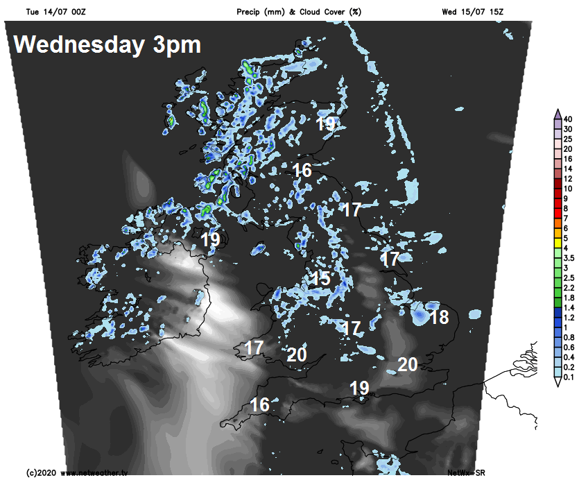
Wednesday may start with some sunshine across East Anglia and the far southeast of England, but generally another cloudy day with occasional mostly light showers spreading southeast, perhaps heavier and more persistent rain affecting northern and western Scotland. Best chance of seeing some sunny spells could be across Devon, Cornwall and SW Wales. With all the cloud, temperatures will be disappointing for high summer, reaching 16-20C generally.
Tomorrow’s cloudy and damp conditions will be brought along courtesy of a warm front, this will clear east as we head into Thursday and introduce warmer and more humid air from the southwest, so temperatures will be higher for many. But with the moisture there will be a lot of cloud spilling east across many parts, so sunshine will be limited. Most dry away from northwest – where some patchy rain is likely. Best chance of sunshine could be east of high ground across eastern Scotland where we could see the highest temperatures – reaching the mid-20s Celsius, generally a little warmer though, with temperatures reaching 18-22C.
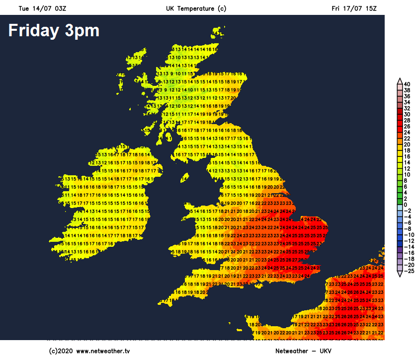
Warmer still on Friday across the south, as the wind switches to a southwesterly drawing in warmer air and introducing sunnier skies to England and Wales, temperatures reaching 25-27C towards SE England, 20-24C elsewhere. Cooler and cloudier across west Wales, Cumbria, Scotland and N. Ireland – where patchy rain or drizzle will be replaced by more persistent rain from the west into the afternoon, as a cold front moves down.
Cold front continuing southeast across England and Wales on Saturday, bringing cloudy skies southeast and a band of rain with it, reaching SE England and East Anglia during the evening. Brighter but fresher conditions following from the northwest across northern areas through the day, but with showers across Scotland, heavy across the north. Perhaps reaching 24C in the southeast, but generally falling into the high teens elsewhere as the cold front clears. Sunday cooler and fresher but with sunny spells across all parts, a few scattered showers developing, perhaps heavy over Scotland. Temperatures reaching high teens to low twenties in the south, mid-teens in the north.