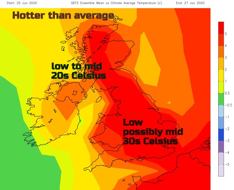
As temperatures move from the mid to high 20sC into the 30sC this week, the hot summer weather could once again bring the risk of thundery downpours.
It is hotting up this week. Very warm air looks like lifting the temperatures in parts of England, possibly for Wales too, into the 30sC from Wednesday onwards. This could set off severe thunderstorms.
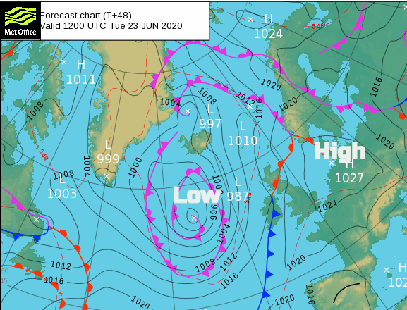
A large low pressure to the west of the UK will keep the weather more unsettled to start the week and a feed of fresher air. High pressure over mainland Europe brings more settled weather and will help the feed of much warmer air in the coming days.
A cooler start today with rain already over Northern Ireland and western Scotland with blustery winds. After a heavier pulse of rain for SW Scotland this morning the rain will turn heavier later on today, with outbreaks still over Northern Ireland and Scotland, although more sheltered in the NE. Most of England and Wales remain dry and sunny although there will be rain for Cumbria later this morning and the Isle of Man with rain clipping NW Wales later this afternoon.
In the south to south-easterly wind temperatures will reach the low 20sC for inland England with fine sunshine, 24C for London. Wales high teens and low 20sC, Cardiff 22C. Northern Ireland and Scotland mid to high teens and windy particularly for the Western Isles by lunchtime.
The frontal rain band still lingers for Tuesday with more cloud and outbreaks of rain over Northern Ireland and central Scotland to start the day. England and Wales have another fine day, getting warmer with a light southerly breeze. Temperatures throughout the 20sC. Not as warm for Northern Ireland and Scotland although Grampian could see 23C in the southerly wind.
By Wednesday the frontal band will have faded a lot, still bringing cloud and damp weather to western Scotland but for much of Britain, it will be fine, dry and sunny with heat. Northern Ireland will have more cloud but Belfast up to 21C with hardly any breeze.
The next few days will see temperatures well into the 20sC with a SE wind. As the heat builds some parts of SE Britani, even the Midlands could reach 30C and London seeing 31 to possibly 34C Wednesday or Thursday. A small risk of thunderstorms in NW on Thursday, spreading to western UK by late evening.
Friday looks more uncertain. This is when the risk of thunderstorms is higher, still the potential for temperatures to reach over 30 Celsius. These thunderstorms would bring the risk of torrential rain, lightning, hail and gusty winds. They swing eastwards during the day and spread northwards by Friday evening. There is a lot of uncertainty for any detail, but the ingredients are there. Your weather app maybe showing thunderstorms or heavy showers on Friday but we will have to wait until nearer the time to see where the focus areas for these will be and even within that, some places will miss them and others risk flooding.
And so, we have now passed the summer solstice; a weekend of long-lasting light, some rain but stunning sunsets and incredible noctilucent cloud displays. Usually you would have to invest to see the NLCs (noctilucent clouds), sometimes staying up until 1am to 3am. This weekend there were less tiring views before midnight. You need to look northwards, often low on the horizon (but not last night) as the set sun’s rays manage to still reach these night-shining very high clouds.